- Home
- About
- Map
- Trips
- Bringing Boat West
- Migration West
- Solo Motorcycle Ride
- Final Family XC Trip
- Colorado Rockies
- Graduates' XC Trip
- Yosemite & Nevada
- Colorado & Utah
- Best of Utah
- Southern Loop
- Pacific Northwest
- Northern Loop
- Los Angeles to NYC
- East Coast Trips
- Martha's Vineyard
- 1 Week in Quebec
- Southeast Coast
- NH Backpacking
- Martha's Vineyard
- Canadian Maritimes
- Ocracoke Island
- Edisto Island
- First Landing '02
- Hunting Island '02
- Stowe in Winter
- Hunting Island '01
- Lake Placid
- Chesapeake
- Provincetown
- Hunting Island '00
- Acadia in Winter
- Boston Suburbs
- Niagara Falls
- First Landing '99
- Cape Hatteras
- West Coast Trips
- Burning Man
- Utah Off-Roading
- Maui
- Mojave 4WD Course
- Colorado River Rafting
- Bishop & Death Valley
- Kauai
- Yosemite Fall
- Utah Off-Road
- Lost Coast
- Yosemite Valley
- Arizona and New Mexico
- Pescadero & Capitola
- Bishop & Death Valley
- San Diego, Anza Borrego, Joshua Tree
- Carmel
- Death Valley in Fall
- Yosemite in the Fall
- Pacific Northwest
- Utah Off-Roading
- Southern CA Deserts
- Yosemite & Covid
- Lake Powell Covid
- Eastern Sierra & Covid
- Bishop & Death Valley
- Central & SE Oregon
- Mojave Road
- Eastern Sierra
- Trinity Alps
- Tuolumne Meadows
- Lake Powell Boating
- Eastern Sierra
- Yosemite Winter
- Hawaii
- 4WD Eastern Sierra
- 4WD Death Valley +
- Southern CA Deserts
- Christmas in Tahoe
- Yosemite & Pinnacles
- Totality
- Yosemite & Sierra
- Yosemite Christmas
- Yosemite, San Diego
- Yosemite & North CA
- Seattle to Sierra
- Southwest Deserts
- Yosemite & Sierra
- Pacific Northwest
- Yosemite & South CA
- Pacific Northwest
- Northern California
- Southern Alaska
- Vancouver Island
- International Trips
- Index
- Tips
- Books
- Photos/Videos
- Search
- Contact
Ancient Bristlecone Pine Forest, CA
Monday, July 13, 2020 - 11:45am by Lolo
80 miles and 3 hours from our last stop - 1 night stay
Travelogue
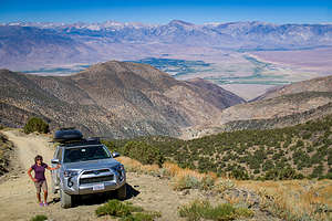 Along the drive up Silver CanyonAndrew and Celeste were working, so Herb and I decided to go to the the Ancient Bristlecone Pine Forest for an overnighter.
The Bristlecones are due east from Bishop, about 15 miles as the crow flies, but a much longer 40 mile drive south to Big Pine on 395 and then right back up north on 168. However, with a High Clearance 4WD there is a much more direct way up Silver Canyon. It might not save much on time, but it certainly was more scenic.
So rather than going south on 395 to Big Pine, we drove 4 miles north from Andrew’s on U.S. 6 and made a right onto Silver Canyon Road.
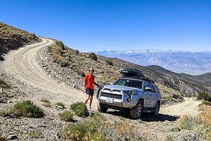 During the drive up Silver CanyonThe road was very steep, climbing from 4,200 feet to 10,400 feet in elevation in just 11.4 miles. We had to make several stream crossings, but the water wasn’t too deep. The last part of the drive became steeper and narrower, with tight switchbacks, but nothing really technical.
We stopped a few times to look back at the tremendous view out over the Owens Valley with the Sierra behind, which is why the 4WD book recommends taking this road down rather than up.
Eventually we came out onto the White Mountain Road which would bring us to the Ancient Bristlecones, the world’s oldest known living organism, some of them dating back as far as 5,000 years ago.
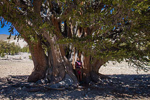 Lolo and the Patriarch TreeThey are very photogenic, each of them individually sculpted by thousands of years of wind, ice, and extreme exposure to the elements. Their twisted and contorted shapes are evidence of their ability to not only survive, but to thrive in adverse living conditions. It’s funny how the harshest growing conditions produce trees that live the longest and are the most contorted and interesting. There’s much to be said for tough love.
There are two groves in the Park: the Patriarch Grove and the Schulman Grove. We decided to go first to the Patriarch Grove first, hoping to be able to camp somewhere nearby, to catch the evening and morning light on the bristlecones. The Grandview Campground, the only official one in the Ancient Bristlecones, was closed due to Covid.
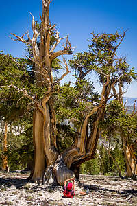 Lolo wanting a different perspective of a bristleconeWhen we got to the Patriarch Grove parking area, a sign very clearly stated “No camping,” so, so much for that. Herb mentioned that another camping possibility was the White Mountain trailhead about 5 miles up a dirt road. Since it was outside the boundaries of the Ancient Bristlecones and used as a starting point for backpacking trips, camping was permitted.
There are two short trails in the area. We set off first on the quarter-mile long Timberline Ancients trail, which loops through the grove containing the Patriarch Tree, the world’s largest bristlecone pine, with a 36-foot diameter. I made Herb take a picture of me happily nestled within its gnarly arms.
Afterwards, we took the half-mile long Cottonwood Basin Overlook trail, which led up to a vista point looking out over Cottonwood Basin and back overlooking the Patriarch Grove, which we had walked through earlier. We could even see the ranges of the Great Basin to the east.
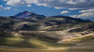 Along the ride from the Patriarch Grove to the White Mountain TrailheadWe were still unsure what to do about camping, so while waiting for the light to get lower, we took a drive out to the White Mountain Trailhead, where Herb thought we might be able to spend the night. The 5-mile drive there was worth it, even if just for the beautiful scenery along the way.
When we got to the parking lot there were half a dozen cars there and room for plenty more. We would have to see what we felt like later.
In the meantime, we drove back to the Patriarch Grove to see it in the changing evening light. As the sun got low, so did the temperatures. After all, we were at 11,300 feet.
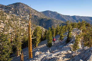 Lolo sets out on the Methuselah TrailThe debate about camping here got a little tense. I like to follow the rules and didn’t feel at all comfortable staying in a parking lot that clearly said, “No Camping.” Herb felt like others were doing it and that it really was the only way to get good photographs after dark.
I won, and Herb very begrudgingly agreed to move the car to a legit spot. He didn’t want to drive the windy road up to the White Mountain Trailhead in the dark, so we just drove a few miles down White Mountain Road to a pullout with a really nice view over the mountains. Herb informed me in the morning that we were still within the boundaries of the Ancient Bristlecone Pine Forest, so this was probably not allowed as well. Oh well.
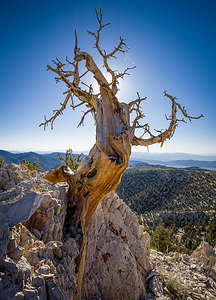 Along the Methuselah Trail in the Schulman GroveThe next morning we drove to the other grove in the park, the Schulman Grove, where the Visitor Center is, although it was closed now due to Covid. From the Visitor Center there are two trails: the 1-mile Discovery Trail and the 5-mile Methuselah Trail
We took the Methuselah Trail, named for the oldest documented living tree in the world which lives along this trail. It is estimated to be over 4,750 years old. Unfortunately, although we would most likely see it, we wouldn’t know when, because its location is kept a secret, for fear that someone might cut it down or harm it in some way. How sad is that?
The trail was lovely, winding its way for 4 ½ miles through bristlecone pines, both ancient and new – some of the baby ones were probably only about a thousand years old.
They are truly beautiful trees, with a rich red-brown colored wood, and their twisted and gnarled branches, shaped by the extreme wind and harsh environment they grow in. They thrive under adversity - what a wonderful trait.
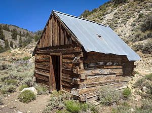 Old Miner's cabin made of railroad ties along the Wyman Creek RoadWe decided to take a different way back to Bishop, along the 4WD Wyman Creek Trail, an old mining and pole line road that would bring us down to 168 and eventually Big Pine.
The trailhead, which was at 10,500 feet, wasn’t far from the Schulman Visitor Center - just a few miles on White Mountain Road, then a short distance on Silver Canyon.
We weren’t on the Wyman Creek road for even a mile before we came upon a quaint old miner’s cabin made of railroad ties and a tin corrugated roof. When I peeked through it’s open door, I felt like an old silver prospector calling on a friend.
The road passed the now abandoned White Mountain City, an old 1860s silver processing town. All that remained were some stone walls and smelter stacks.
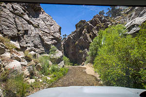 Crossing Wyman CreekThe road continued steadily downhill through gentle switchbacks into Wyman Canyon, passing the now abandoned White Mountain City, an old 1860s silver processing town. All that remained were some stone walls and smelter stacks.
After this point, the road started to criss-cross the canyon’s stream several times, but fortunately it was fairly shallow and mellow. I can imagine that after a storm, it is a very different story.
After a few miles more of following the stream, we came out into an open boulder field before arriving at Highway 168. Asphalt again.
Unlike our shortcut from Bishop up Silver Canyon to the Bristlecones, we had really taken the long way around this time. It was an hour drive from here back through Big Pine and then up to Bishop.
What a great road. It felt like a journey through time.
- ‹ previous
- 4 of 6
- next ›
Ancient Bristlecone Pine Forest location map in "high definition"
Javascript is required to view this map.
