- Home
- About
- Map
- Trips
- Bringing Boat West
- Migration West
- Solo Motorcycle Ride
- Final Family XC Trip
- Colorado Rockies
- Graduates' XC Trip
- Yosemite & Nevada
- Colorado & Utah
- Best of Utah
- Southern Loop
- Pacific Northwest
- Northern Loop
- Los Angeles to NYC
- East Coast Trips
- Martha's Vineyard
- 1 Week in Quebec
- Southeast Coast
- NH Backpacking
- Martha's Vineyard
- Canadian Maritimes
- Ocracoke Island
- Edisto Island
- First Landing '02
- Hunting Island '02
- Stowe in Winter
- Hunting Island '01
- Lake Placid
- Chesapeake
- Provincetown
- Hunting Island '00
- Acadia in Winter
- Boston Suburbs
- Niagara Falls
- First Landing '99
- Cape Hatteras
- West Coast Trips
- Burning Man
- Utah Off-Roading
- Maui
- Mojave 4WD Course
- Colorado River Rafting
- Bishop & Death Valley
- Kauai
- Yosemite Fall
- Utah Off-Road
- Lost Coast
- Yosemite Valley
- Arizona and New Mexico
- Pescadero & Capitola
- Bishop & Death Valley
- San Diego, Anza Borrego, Joshua Tree
- Carmel
- Death Valley in Fall
- Yosemite in the Fall
- Pacific Northwest
- Utah Off-Roading
- Southern CA Deserts
- Yosemite & Covid
- Lake Powell Covid
- Eastern Sierra & Covid
- Bishop & Death Valley
- Central & SE Oregon
- Mojave Road
- Eastern Sierra
- Trinity Alps
- Tuolumne Meadows
- Lake Powell Boating
- Eastern Sierra
- Yosemite Winter
- Hawaii
- 4WD Eastern Sierra
- 4WD Death Valley +
- Southern CA Deserts
- Christmas in Tahoe
- Yosemite & Pinnacles
- Totality
- Yosemite & Sierra
- Yosemite Christmas
- Yosemite, San Diego
- Yosemite & North CA
- Seattle to Sierra
- Southwest Deserts
- Yosemite & Sierra
- Pacific Northwest
- Yosemite & South CA
- Pacific Northwest
- Northern California
- Southern Alaska
- Vancouver Island
- International Trips
- Index
- Tips
- Books
- Photos/Videos
- Search
- Contact
Beluga Point / Turnagain Arm, AK
Tuesday, July 18, 2006 - 10:30am by Lolo
281 miles and 6 hours from our last stop
Travelogue
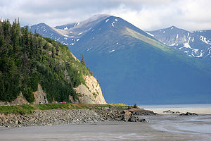
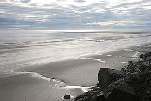
 Turnagain ArmSouth of Anchorage, the Seward Highway traces the north shore of the Turnagain Arm and becomes incredibly scenic. If you are fortunate, you'll time your drive to coincide with one of the phenomenal bore tides, in which an 8 foot wall of water rushes in from Cook Inlet covering the exposed mudflats at a speed of 10 mph. Unfortunately, our timing was not so good, but we did get to see it at low tide right before sunset, which was a pretty spectacular sight as well. Herb and the boys must have spent close to an hour photographing the flats.
Description
 Turnagain Arm mud flatsThe drive along the Seward Highway from Anchorage to Portage traces the north coast of Turnagain Arm. The Turnagain Arm got its name from Captain James Cook in 1778 when instead of finding the Northwest Passage, he was forced to "turn again" when he hit a dead end.
There are many scenic turnouts along the stretch from Milepost 115 to 90. Beluga Point at Milepost 110.4 is one of the best of them. It's called Beluga Point because it's a great place to see the beluga whales chase the salmon into Turnagain Arm in late May and late August.
Turnagain Arm is also known for its phenomenal bore tides. When the incoming tide flows from Cook Inlet into the much shallower and narrower Turnagain Arm, a wall of water as high as 8 feet tall and ½ mile wide across comes surging into the Arm at a speed of 10 mph. The bore tide is best seen between Girdwood and Beluga Point about 2 hours after the Anchorage low tide.
Warning: It is extremely dangerous to wander out onto the mud flats at any time because the mixture of silt and mud acts as a kind of quicksand.
- ‹ previous
- 4 of 12
- next ›
Beluga Point / Turnagain Arm location map in "high definition"
Javascript is required to view this map.
