- Home
- About
- Map
- Trips
- Bringing Boat West
- Migration West
- Solo Motorcycle Ride
- Final Family XC Trip
- Colorado Rockies
- Graduates' XC Trip
- Yosemite & Nevada
- Colorado & Utah
- Best of Utah
- Southern Loop
- Pacific Northwest
- Northern Loop
- Los Angeles to NYC
- East Coast Trips
- Martha's Vineyard
- 1 Week in Quebec
- Southeast Coast
- NH Backpacking
- Martha's Vineyard
- Canadian Maritimes
- Ocracoke Island
- Edisto Island
- First Landing '02
- Hunting Island '02
- Stowe in Winter
- Hunting Island '01
- Lake Placid
- Chesapeake
- Provincetown
- Hunting Island '00
- Acadia in Winter
- Boston Suburbs
- Niagara Falls
- First Landing '99
- Cape Hatteras
- West Coast Trips
- Burning Man
- Utah Off-Roading
- Maui
- Mojave 4WD Course
- Colorado River Rafting
- Bishop & Death Valley
- Kauai
- Yosemite Fall
- Utah Off-Road
- Lost Coast
- Yosemite Valley
- Arizona and New Mexico
- Pescadero & Capitola
- Bishop & Death Valley
- San Diego, Anza Borrego, Joshua Tree
- Carmel
- Death Valley in Fall
- Yosemite in the Fall
- Pacific Northwest
- Utah Off-Roading
- Southern CA Deserts
- Yosemite & Covid
- Lake Powell Covid
- Eastern Sierra & Covid
- Bishop & Death Valley
- Central & SE Oregon
- Mojave Road
- Eastern Sierra
- Trinity Alps
- Tuolumne Meadows
- Lake Powell Boating
- Eastern Sierra
- Yosemite Winter
- Hawaii
- 4WD Eastern Sierra
- 4WD Death Valley +
- Southern CA Deserts
- Christmas in Tahoe
- Yosemite & Pinnacles
- Totality
- Yosemite & Sierra
- Yosemite Christmas
- Yosemite, San Diego
- Yosemite & North CA
- Seattle to Sierra
- Southwest Deserts
- Yosemite & Sierra
- Pacific Northwest
- Yosemite & South CA
- Pacific Northwest
- Northern California
- Southern Alaska
- Vancouver Island
- International Trips
- Index
- Tips
- Books
- Photos/Videos
- Search
- Contact
Bishop, CA
Thursday, August 24, 2023 - 4:45pm by Lolo
190 miles and 4 hours from our last stop - 6 night stay
Travelogue
Now it was on to Andrew and Celeste’s house in Bishop for a 5-day stay.
As I have mentioned in the past, our son Andrew and his wife Celeste, moved from San Francisco to Bishop in 2019 to try out a less-urban lifestyle in what is a world-class rock climbing destination. They were fortunate enough to be able to take their San Francisco jobs with them - and this was before Covid.
Bishop and all of the Eastern Sierra is stunningly beautiful, so even though they are 6 ½ hours away from us now, it is not a hardship to go over the mountains to visit them. Their home is often the first or last stop on one of our road trips.
This time it wasn’t exactly on the way home, but still quicker than going all the way home and back.
The drive on Highway 395 south from Reno, also known as the Eastern Sierra Scenic Byway, is probably one of the most beautiful drives in the U.S. The 133-mile stretch from the Nevada border to Bishop is loaded with scenic vistas, each more beautiful than the next.
Day 1 - South Lake to Long Lake hike
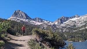 South Lake to Long Lake HikeIt was Friday, which means work day for Andrew and Celeste, so Herb and I decided to do the hike from South Lake to Long Lake, about a half hour drive from their place. We had done this hike back in 2019, and I had gotten terrible altitude sickness. This time I would make sure to drink lots of water along the way.
The nice thing about hiking in Bishop is that no matter how hot it is (it’s very hot in the summer), you can just drive for 20 to 30 minutes to higher elevations and pretty much dial in the temperature you want. This hike started at 9,750 feet, and we really weren’t acclimated yet.
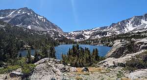 South Lake to Long Lake HikeThe trail to Long Lake starts at the end of South Lake Road (elevation (9,800) and climbs steadily uphill along the eastern shore of lovely South Lake. We continued climbing steadily up until after about 3 miles we reached Long Lake, another stunningly beautiful alpine lake at 10,760 elevation - so we had climbed over 1,000 feet already.
The mosquitoes were terrible at the lake, so I stopped to put mosquito repellent on my arms. I use Picaridin because it doesn’t have Deet. While it definitely worked on my arms, they started biting me right through my shirt, so I had to add more there. I was pretty much covered with bites.
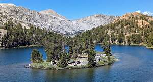 South Lake to Long Lake HikeAfter all that work going uphill, the way back was pretty much all downhill. In total, the hike was about 5 miles with a 1,036 elevation gain. But, it was pretty hard for us because it started at around 9,800 feet, and we were not acclimated yet. Still, the stopping to drink water every half hour definitely held off the altitude sickness I experienced the last time.
So no altitude sickness, but this time I had to worry about my mosquito bites, because today’s Inyo Register reported that mosquito pools in Bishop had tested positive for encephalitis and West Nile disease. Oh great.
Andrew and Celeste are terrific hosts, so they prepared dinner for us that night, as they would every night during our stay. What a great Airbnb
Day 2 - Ancient Bristlecones with the Rotary Club
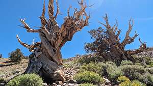 Ancient BristleconesIt was Saturday, so no work for the kids today. Andrew mentioned that their Rotary Club was having a field trip up to the Ancient Bristlecones and that a naturalist would lead us on a hike along the Discovery Trail.
We had been to the Bristlecones before, but not that trail, and not with our own naturalist. So we happily climbed into Andrew’s car and drove down to Big Pine and then east on State Highway 168 up to the Schulman Grove Visitor Center where we would all be meeting.
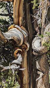 Twisted BristleconeIt was a great group of people and our naturalist guide was very fun and informative.
I already knew that bristlecone pines are the oldest known living trees, but along our 1-mile hike on the Discovery Trail, I learned a few new things from our naturalist guide.
The twisted and seemingly half-dead trunks associated with bristlecones are the result of a trait called sectored architecture. This means each tree root only feeds the part of the tree directly above it. So if a root dies, only the tree section that’s directly connected to that root dies. This trait allows the bristlecone to draw all available water and nutrients to a small percentage of the tree during drought periods. The dead, sculpted trunks are sections the trees let die to save itself in the long term. It is common at high elevations to see bristlecone pines with only one or two living sectors, defined by a strip of bark.
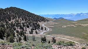 Bristlecone forest on dolomite soil hillThe Ancient Bristlecones also prefer rocky dolomite soils where most other types of vegetation cannot grow. This lack of vegetation helps reduce fire danger, as the isolated Bristlecone trees are often perched on rocky outcroppings with no surrounding surface fuels to catch on fire.
That's why only bristlecones grow on the dolomite hillside, while on the flatter clayier area below, there are no Bristlecones, but only grasses and other shrubs.
It was a very fun and educational day. Thank you Bishop Rotary Club!
Day 3 - Family hang-out day
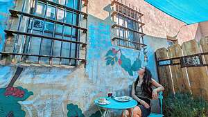 Bishop Coffee ChurchSunday morning in Bishop means Coffee Church, a secular gathering of friends, family, and neighbors at the Indy Roasting Company. In addition to Coffee Pour Overs and Mexican and Scandinavian Coffee Drinks, there are delicious home-made artisan pastries. We try to go there whenever we are in town.
Afterwards it was father-son bonding time with some home maintenance. Herb and Andrew had a very productive day installing recessed lighting in their Family Room ceiling. Andrew has gotten so handy that Herb wants to enlist him to help do the same in our Family Room.
The event we were all looking forward to today, however, was dinner at the Mono Inn to partake in their highly rated 5-course Summer Tasting Menu. Mono Lake is about an hour drive north of Bishop on the highly scenic Highway 395, also known as the Eastern Sierra Scenic Byway.
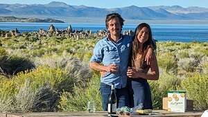 Pre-dinner cocktail hour at the South TufasWe went up a bit ahead of time to have pre-dinner wine and cheese at the South Tufa Reserve on the South side of the lake - a stunning setting, especially during sunset.
Then it was on to the historic Mono Inn. Originally established in 1922, the Historic Mono Inn has been a destination for hungry, weary travelers in the eastern Sierra Nevada for decades. Wow, and here we were, four hungry, weary travelers cruising up 395 looking for a good meal over 100 years later.
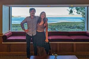 Mono Inn ViewIn 1996, the inn was bought by the Ansel Adams family, who remodeled it into a beautiful gallery and restaurant. With its sweeping, majestic view of Mono Lake, it became a cornerstone of fine dining in the area.
In 2007, Sarah Adams (Ansel Adams’ granddaughter) closed the Inn and moved back to the coast. It changed hands a bit for the next 14 years, but has been under new ownership since May 2021. All I could find on the internet is that the new owner is named Hillary and the Chef is Jason Custer.
I had never been here before, but whatever they have done is incredible. The food is creative and delicious, the service is impeccable, and the views are amazing.
What a great experience!
Day 4 - Little Lakes to Gem Lake
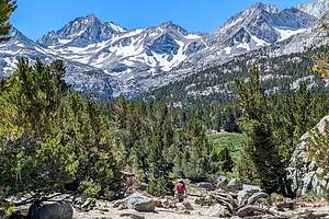 Little Lake to Gem Lakes hikeAnother day, another awesome hike, once again at a higher elevation than Bishop to escape the Bishop heat. It’s nice how you can pretty much dial in the temperature you want by just driving to a trailhead at a higher elevation.
Today’s hike was to be a longer one - an 8-mile, out-and-back hike from the Rock Creek parking lot past several alpine lakes to Gem Lake, which is at an elevation of a little over 11,000 feet. That’s pretty high, so I would have to make sure that I stopped frequently to drink enough water to fend off the altitude sickness which I tend to be susceptible to.
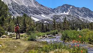 Little Lakes to Gem Lakes hikePlus, I proactively put on insect repellent after my mosquito experience on the Long Lake hike, especially after learning that mosquito pools around Bishop had recently tested positive for encephalitis.
This is an extremely popular hike, so the parking lot was already full when we got there around 11:00 am - a bit late for hikers. We had to drive back down the road a half mile to another lot, adding 1 mile to our already long 8-mile hike.
From the real parking lot, we set out on a fairly flat trail that parallels Rock Creek, with nice mountain views along the way. There was also plenty of colorful lupine and Indian paintbrush to even further improve the scenery.
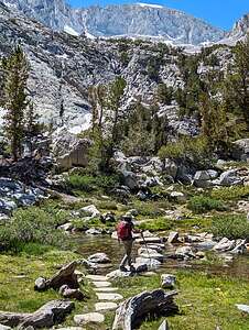 Getting closer to Gem LakeWe passed several pretty alpine lakes along the way - Mack Lake, Marsh Lake, Heart Lake, Box Lake, and then Long Lake, where we stopped to eat our lunch. By now we had hiked about 2.5 miles and only climbed about 350 feet.
After lunch we continued walking along Long Lake for about a half mile before beginning another ascent, probably the steepest part of the trail.
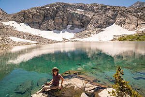 Gem Lake at lastWe skipped the detour to Chickenfoot Lake and began ascending the main trail towards Morgan Pass and Gem Lakes. To get to Gem Lake, we had to cross a stream by balancing our way over a few logs and rocks that seemed to be placed to ensure an easy crossing.
After a bit more ascent, we passed several of the gem lakes before arriving at the final and largest of the Gem Lakes, situated in a bowl below sheer granite faces and steep boulder fields. The water was a brilliant turquoise blue.
It was so beautiful that we hung out there for a bit before heading back. All in all, it was 9 miles with 1,122 feet of elevation gain, which isn’t much for that distance.
Then it was back to Bishop for another great dinner and evening with Andrew and Celeste.
Day 5 - Convict Lake chill day
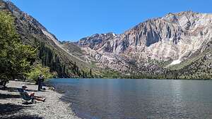 Chilling at Convict LakeWe briefly considered doing a 10-mile, 3,000-foot elevation gain hike to the Big Pine Lakes today, but then reconsidered and instead decided to bring our kindles and relax and read beside beautiful Convict Lake, another one of the Eastern Sierra gems.
Unlike the other stunning alpine lakes we had hiked to this week, this one can be driven right up to. The distance from our car to the lake was probably 20 yards. Perfect!
Carved out by glaciers, this beautiful oblong-shaped lake is filled with turquoise-blue water as clear as glass, and surrounded by a box canyon set in the mountains. Mount Morrison, the tallest mountain in the area at 12,241 feet, rises above the southeast end of the lake.
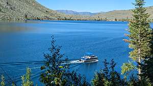 Convict LakeThe lake is known for its great trout fishing, but I couldn’t get Herb to trade his kindle for a fishing rod.
There is an interesting story behind how Convict Lake got its name. Way back in 1871, a group of convicts escaped from a prison in Carson City, Nevada, and took refuge near the lake, which was then called Monte Diablo. They were pursued by a posse and a shootout began, killing a number of both posse members and convicts. The large peaks above the lake were renamed after the fallen posse members and the lake itself became known as Convict.
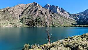 Convict LakeWe spent a very pleasant few hours reading our books, occasionally looking up to take in the scenery and watch the pontoon boats leisurely cruise along the lake.
At 4:00, we decided it was time to move our bodies a bit, so we took the lovely 3-mile stroll around the perimeter of the lake. About halfway around, we had to take off our shoes to cross the Convict Creek inlet, which covered a good 30 feet or so of the trail.
So, it was another great day in the Eastern Sierra.
Tomorrow we would head back home to Sonoma Valley. There was so much variety along this trip that it felt like we had been away for a month.
- ‹ previous
- 13 of 13
Bishop location map in "high definition"
Javascript is required to view this map.
