- Home
- About
- Map
- Trips
- Bringing Boat West
- Migration West
- Solo Motorcycle Ride
- Final Family XC Trip
- Colorado Rockies
- Graduates' XC Trip
- Yosemite & Nevada
- Colorado & Utah
- Best of Utah
- Southern Loop
- Pacific Northwest
- Northern Loop
- Los Angeles to NYC
- East Coast Trips
- Martha's Vineyard
- 1 Week in Quebec
- Southeast Coast
- NH Backpacking
- Martha's Vineyard
- Canadian Maritimes
- Ocracoke Island
- Edisto Island
- First Landing '02
- Hunting Island '02
- Stowe in Winter
- Hunting Island '01
- Lake Placid
- Chesapeake
- Provincetown
- Hunting Island '00
- Acadia in Winter
- Boston Suburbs
- Niagara Falls
- First Landing '99
- Cape Hatteras
- West Coast Trips
- Burning Man
- Utah Off-Roading
- Maui
- Mojave 4WD Course
- Colorado River Rafting
- Bishop & Death Valley
- Kauai
- Yosemite Fall
- Utah Off-Road
- Lost Coast
- Yosemite Valley
- Arizona and New Mexico
- Pescadero & Capitola
- Bishop & Death Valley
- San Diego, Anza Borrego, Joshua Tree
- Carmel
- Death Valley in Fall
- Yosemite in the Fall
- Pacific Northwest
- Utah Off-Roading
- Southern CA Deserts
- Yosemite & Covid
- Lake Powell Covid
- Eastern Sierra & Covid
- Bishop & Death Valley
- Central & SE Oregon
- Mojave Road
- Eastern Sierra
- Trinity Alps
- Tuolumne Meadows
- Lake Powell Boating
- Eastern Sierra
- Yosemite Winter
- Hawaii
- 4WD Eastern Sierra
- 4WD Death Valley +
- Southern CA Deserts
- Christmas in Tahoe
- Yosemite & Pinnacles
- Totality
- Yosemite & Sierra
- Yosemite Christmas
- Yosemite, San Diego
- Yosemite & North CA
- Seattle to Sierra
- Southwest Deserts
- Yosemite & Sierra
- Pacific Northwest
- Yosemite & South CA
- Pacific Northwest
- Northern California
- Southern Alaska
- Vancouver Island
- International Trips
- Index
- Tips
- Books
- Photos/Videos
- Search
- Contact
Death Valley, CA
Wednesday, February 19, 2020 - 8:15pm by Lolo
75 miles and 2 hours from our last stop - 3 night stay
Travelogue
Day 1 - Saline Valley
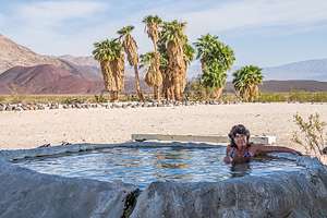 Saline Valley Warm SpringsAfter leaving Bishop, we drove south on 395 to the town of Big Pine and made a left (east) onto State Highway 168. From there it was about 16 miles for the turnoff (on the right) onto the Saline Valley Road.
The turnoff for the Warm Springs can be easy to miss, so we reset our odometer so we could track our progress along the way. At exactly 32.7 miles (as our off-roading guide told us), we came to a big old truck tire on our left, making the turn onto Warm Springs Road.
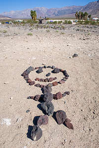 Saline Valley rock artThe drive along Warm Springs Road was much rougher and sandier than the Saline Valley Road, as the Saline Valley Road is maintained and graded, but this one is not. Still, plenty of 2WD cars and even small motorhomes somehow make it through. Funny how motivational the thought of soaking in a beautiful palm oasis can be.
After about 4 miles into our bumpy drive to the Palm Spring Oasis, we came to a tall post with metal bats hanging from it - the infamous “Bat Pole” of Saline Valley.
At about 6.5 miles, we arrived at the first oasis, where we had camped on a previous visit. However, we decided to continue on another mile to the second oasis. This one tends to be less crowded and it has two beautiful pools - one out in the open, hot desert sun, and the other tucked under the shade of a palm tree.
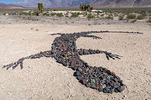 Saline Valley rock artBoth oases are amazing – prettier and better maintained than most commercial hot springs. They were developed in the 60s, before Saline Valley became a part of Death Valley National Park, by a group of hippies who made a semi-permanent camp here – taming the wild springs into several concrete, rock, and tile soaking pools. The camp even had a leader named “Wizard.” When he passed away, “Lizard” took his place. You can’t make this stuff up.
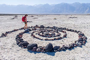 Lolo participating in the rock artThere are even showers, with soap and shampoo supplied, to use before entering the pool. In addition, there is a fully stocked bathroom, with Costco size toilet paper packages, cleaning products, air fresheners, etc.
Plus, there is random artwork near the bathrooms - giant lizards, stick men, insects, spiral mazes, peace signs, and more made from the volcanic black and red rock that is scattered all about.
This place certainly felt more like a commune than part of a National Park. The only stress here is deciding whether to soak in the sunny or the shady pool.
Day 2 - Saline Valley - Cinder Cone Hike
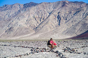 Random car seat along the way to the Peace SignFrom the oasis, there is a very prominent red cinder cone about two miles east of the springs with a giant peace sign carved into it - also not done by the National Park Service, but rather the work of two hippies from San Francisco named Sunshine (of course) and Raymond (not as predictable) who were residents of the Valley in the 1960s.
In 1968, Sunshine decided to take a rake to the cinder cone, where she set about the herculean task of removing the surface red volcanic cinders and exposing the lighter-colored volcanic soil below to create a giant peace sign, which must be at least 100 feet in diameter.
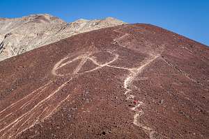 Lolo on her way up to the Peace SignI have no idea how she could have possibly done this, as it is so huge that when you are near it, you can’t actually see that it is a peace sign. Hopefully, Raymond and some other friends helped her.
This peace sign was our hiking goal for the day. We headed to the first palm oasis, a little less than a mile away, before heading across the Valley towards the cinder cone. We didn’t get too far before we came upon a car seat, just sitting there in the middle of nowhere. Of course, we had to each sit in it to have our picture taken.
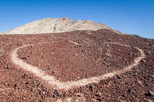 Peace and LoveFrom there we just kept walking toward the peace sign across the rocky terrain, which had dozens of washes and gullies running counter to the direction we were headed, which meant we had to constantly climb down one side and up the other of each of them. It seemed that no matter how long we walked, the cinder cone wasn’t getting any closer.
Finally, after about another 1.2 miles, we snuck up on it and began the very steep ¾-mile climb up its side to the peace sign. It was very hard, and part of the way, the peace sign disappeared behind it. When we finally got up to the peace sign, it was hard to tell it was one, because it was so huge.
Getting down the steep path was no piece of cake either as we slipped and slid on the loose scree. Then it was another mile back across the rocky washes to our palm oasis.
Final tally was 4.5 miles.
Time for a shower, soak, and bed.
Day 3 - Eureka Dunes
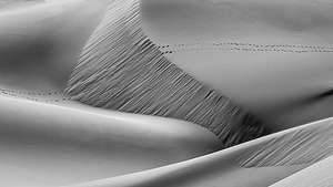 Eureka DunesThe next morning, we drove back north on the Saline Valley Road to the Big Pine Road. We then turned right (east) and drove for about 25 miles and then made a right onto South Eureka Road.
From there, it was another 10 miles along the 4WD South Eureka Road to the primitive campground near the base of the impressive Eureka Dunes. At 700 feet, it is the largest dune in California and the second largest in the entire U.S.
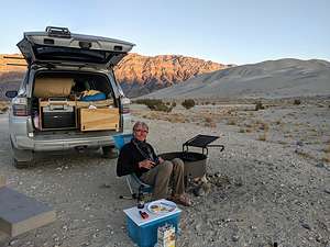
 Eureka DunesThe campground was dry (no water or flush toilets) and had only four designated sites, but fortunately we were able to get one. If this campground is full, there are more dispersed campsites down the road, but it is kind of nice to have a picnic table and an outhouse.
Winter is a great time to visit the dunes, because even in the afternoon it is usually not too hot to hike them. Around 3:00 we set off towards the northern end of the dune and then started our slog up. I always find hiking in deep sand so grueling - 2 steps forward, 1 step back.
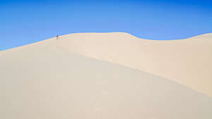 Eureka DunesHerb always sends me ahead, because he likes having a tiny person in his photo to give a sense of scale to this amazing expanse of dunes. In fact, unknown at the time, of course, he took a photo of me along one of the ridges, which went on to win best monochrome photo for 2021 in all of Northern California. That photo is now moving on to complete at the PSA (Photography Society of America) level.
There were portions of the hike that were so steep that I actually had to bend my body forward into the incline and use my hands as well. I looked like a gorilla. Meanwhile, each step on the really steep parts set off what looked like a river of sand, starting about 3 feet above us and continuing right below us for another dozen or so feet. The patterns we created were beautiful.
 Eureka Dunes campsiteBesides the intriguing visual effect, we were also making the dunes “sing.” Singing sand dunes are quite rare and there are only about 40 of them in the entire world. The singing is really more of a booming sound, and it is triggered by an avalanching movement of sand.
It was actually a little tricky finding the summit, and I’m not actually sure that we ever did. as each time we climbed to the top of a ridge, we saw another one higher. We had reached the summit on a previous trip, but as we were now cutting into cocktail hour, we declared victory on the ridge below the summit and started the much more fun trek down. I felt like I was running down a hill of pudding. All in all, the hike was a very rewarding, and exhausting, 2.2 mile round-trip with some significant elevation gain.
Back at our campsite, we made dinner, sipped wine, and watched the sunset. As striking as the dunes are, an equally stunning view from our campsite was of the Last Chance Mountains, rising 700 feet from the Eureka Valley floor, brightly painted by the evening light.
Day 4 - Hidden Dunes and back to Bishop
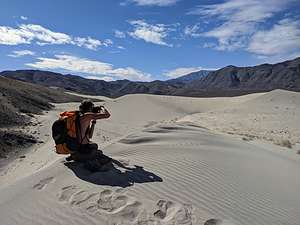 Hidden DunesOn our way out on the South Eureka Road, we decided to take a detour and hike to the Hidden Dunes, the Eureka Dunes’ smaller and lesser-known brother. You don’t even see them when driving along the Eureka Valley Road, because they are obscured from view by a pair of small mountains.
After driving about 6 miles north from the Eureka Dunes (3.5 miles shy of getting back to the Death Valley / Big Pine Road), we turned left on a hard-to-find, unmarked side road - I think it might be named Dry Well Road - at the end of which was a small parking lot.
There was no defined trail, so we set out across a rocky, sandy flat continuously aiming ourselves towards the triangle of sand peeking out from the gap between the two dark, rocky mountains in the distance. We were able to make good time on the hard, firm surface, so it only took us about an hour to cover the 3 miles to the Gap.
.thumbnail.jpg) Hidden DunesAs we rounded the corner, the dunes came out of hiding, seemingly out of nowhere. It was like a portal to another world.
Hidden DunesAs we rounded the corner, the dunes came out of hiding, seemingly out of nowhere. It was like a portal to another world.
We climbed up along the ridge on the first dune and followed its spine to the summit, probably about a 150 foot climb. It was so quiet and pristine, a whole different experience from visiting the other more popular dunes in the park. The only footprints to be found were our own.
The dune fields supposedly go on for 2.5 miles to the south, but we only had time for about ½ mile, before turning back.
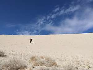
Rather than go back down along a ridge, we ran playfully down its steep side, heels sinking in the sand to slow us down, all the while creating rivulets that began to “sing” as the friction of the sand grains sliding against each other sounded like the bass note of a pipe organ.
 Hidden DunesOn a hike without a well-defined trail, you not only have to think about finding your destination, but also about finding your way back to your car. The old-fashioned way is to take note of a landmark before heading out too far, to which you will navigate back towards later. In the case of this hike, there was a white wellhead mound in the parking lot.
However, we usually rely on the Strava app (or Gaia), which records our hikes as they are happening (distance, speed, etc.) and marks our progress on a map - a more techy version of Hansel and Gretal’s breadcrumbs.
We easily found our way back to the car. The entire hike was 7.2 miles with 100-feet of elevation gain. Very worthwhile and highly recommended.
Now it was back to Bishop and another cozy night with Andrew and Celeste in their new home before heading back to Sonoma.
- ‹ previous
- 2 of 2
