- Home
- About
- Map
- Trips
- Bringing Boat West
- Migration West
- Solo Motorcycle Ride
- Final Family XC Trip
- Colorado Rockies
- Graduates' XC Trip
- Yosemite & Nevada
- Colorado & Utah
- Best of Utah
- Southern Loop
- Pacific Northwest
- Northern Loop
- Los Angeles to NYC
- East Coast Trips
- Martha's Vineyard
- 1 Week in Quebec
- Southeast Coast
- NH Backpacking
- Martha's Vineyard
- Canadian Maritimes
- Ocracoke Island
- Edisto Island
- First Landing '02
- Hunting Island '02
- Stowe in Winter
- Hunting Island '01
- Lake Placid
- Chesapeake
- Provincetown
- Hunting Island '00
- Acadia in Winter
- Boston Suburbs
- Niagara Falls
- First Landing '99
- Cape Hatteras
- West Coast Trips
- Burning Man
- Utah Off-Roading
- Maui
- Mojave 4WD Course
- Colorado River Rafting
- Bishop & Death Valley
- Kauai
- Yosemite Fall
- Utah Off-Road
- Lost Coast
- Yosemite Valley
- Arizona and New Mexico
- Pescadero & Capitola
- Bishop & Death Valley
- San Diego, Anza Borrego, Joshua Tree
- Carmel
- Death Valley in Fall
- Yosemite in the Fall
- Pacific Northwest
- Utah Off-Roading
- Southern CA Deserts
- Yosemite & Covid
- Lake Powell Covid
- Eastern Sierra & Covid
- Bishop & Death Valley
- Central & SE Oregon
- Mojave Road
- Eastern Sierra
- Trinity Alps
- Tuolumne Meadows
- Lake Powell Boating
- Eastern Sierra
- Yosemite Winter
- Hawaii
- 4WD Eastern Sierra
- 4WD Death Valley +
- Southern CA Deserts
- Christmas in Tahoe
- Yosemite & Pinnacles
- Totality
- Yosemite & Sierra
- Yosemite Christmas
- Yosemite, San Diego
- Yosemite & North CA
- Seattle to Sierra
- Southwest Deserts
- Yosemite & Sierra
- Pacific Northwest
- Yosemite & South CA
- Pacific Northwest
- Northern California
- Southern Alaska
- Vancouver Island
- International Trips
- Index
- Tips
- Books
- Photos/Videos
- Search
- Contact
Death Valley National Park, CA
Sunday, November 14, 2021 - 7:15pm by Lolo
40 miles and 3 hours from our last stop - 4 night stay
Travelogue
Day 1 - Titus Canyon and sunset at Zabriskie Point
 Titus Canyon RoadHerb loves Death Valley, and I do too, as long as I don’t have to go in the summer when 108 degrees is considered a cool day. Since moving to the West Coast, we have pretty much gravitated to visiting during the late fall, when we can get in some hikes without fear of heat stroke.
Death Valley is a huge park, the largest outside of Alaska. The valley itself is over 130 miles long, but only 12 miles wide, flanked on both sides by unvegetated reddish mountains.
The park is criss-crossed by a network of roads, ranging from washboard dirt ones to paved, well-maintained highways, making the most popular destinations quite accessible. Other, more remote areas of the park are only accessible with off-road vehicles on some pretty, long bumpy roads.
 Red Pass along Titus Canyon RoadToday, we were to enter the park via one of those long bumpy roads - Titus Canyon. When coming from Beatty, Nevada, which we were, most people enter Death Valley via the Daylight Pass Road. We have done that several times in the past.
However, this time, we wanted to come in via the more dramatic and scenic Titus Canyon Road, a rough and steep road that is 27 miles long and takes about 2 to 3 hours to drive. To get to it from Beatty, we took 374 South for about 6 miles before turning right onto Titus Canyon Road.
While a 2WD may work under good weather conditions, a 4WD is recommended, and, in either case, the vehicle must have high clearance. Also, the road is one-way. You can only go from Beatty into the park, not the other way. The last 3 miles are two-way and can be driven by 2WD, standard clearance vehicles.
 The Narrows of Titus CanyonThe road winds 27 breathtaking miles through the Death Valley backcountry, twisting sharply around steep colorful rock walls.
After about 9 miles the road descends into Titanothere Canyon and then begins to climb up and over Red Pass, which is a mile high with great views.
After 16 miles we entered Titus Canyon, where if you look high up on the walls, you can see petroglyphs.
.thumbnail.jpg) Herb at Zabriskie Point sunsetThe most exciting part was near the end (mile 23.5), where the canyon narrowed so much that we could practically reach our hands out our windows and touch both walls. This was by far our favorite part.
Herb at Zabriskie Point sunsetThe most exciting part was near the end (mile 23.5), where the canyon narrowed so much that we could practically reach our hands out our windows and touch both walls. This was by far our favorite part.
I kept jumping out of the truck at various points to take its picture. Sometimes I even let Herb get in the photo.
At mile 26.6 we were back on asphalt. It was an awesome drive and a great way to enter Death Valley.
We took a left on Scotty’s Castle Road, and at the junction, continued on 190 to the Furnace Creek Ranch, where we would be spending the next two nights.
 Sunset at Zabriskie PointWe were getting soft this trip. Rather than camping in our Toyota 4Runner as we usually do, we decided to live it up and stay in a pretty luxurious hotel. In late November, the days are just too short, and there is nothing else to do but sit in the truck after 4:00 pm when the sun dips behind the mountains.
After checking into our hotel, we continued on to Zabriskie Point to catch the sunset. This is one of the most spectacular overlooks in the park. From the parking lot, it was just a short wall uphill to a panoramic view of Golden Canyon and the surrounding vibrantly colored badlands.
We were a little too late for the best part of sunset, but it was still quite stunning.
Wow! Sunrise at Mono Lake and sunset at Zabriskie Point in one day - not bad.
Day 2 - Sunrise at Zabriskie Point, 20 Mule Canyon Road, and Golden Canyon Hike
 Sunrise Zabriskie PointThe next morning (my second in a row) we were up at 5:00 am to catch another beautiful sunrise, this time at Zabriskie Point, the fabulous viewpoint we had rushed to last night and just missed sunset.
Not being an early morning riser, I was surprised to see how many cars were already in the parking lot. We hiked up the hill to the overlook and saw a sea of tripods at the edge. Apparently, we weren’t the only ones with this idea.
Herb found his vantage point amongst his camera-wielding brethren and patiently waited for the sun to rise above the mountains across the Valley and begin to paint the canyon in vibrant colors - pastel pink and blue sky, and earthy brown and golden canyon. It was absolutely breathtaking.
 Sunrise Zabriskie PointMany of the photographers there were part of a photo workshop group, and we could see the leader running back and forth from tripod to tripod, like a mother hen, encouraging and advising each of the members of her group. This would not be the only time we would run into this particular group, which pretty much confirmed to us that we were going to the right places at the right times.
The spectacular colorful landscape doesn’t just stop at Zabriskie Point, but extends several miles to the southeast and can be experienced up close and personal along the Twenty Mule Team Canyon Road, an unpaved, one-way road that winds for 2.5 miles through colorful, eroded badlands - black and dark brown to the west; tan, yellow, and white to the east.
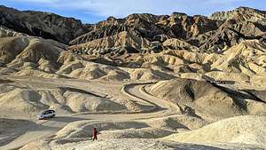 Twenty Mule Team Canyon RoadThe road is named for the teams of eighteen mules and two horses that pulled wagons loaded with borax out of this canyon from 1883 to 1889.
Death Valley would have had minimal human history if it wasn’t for the discovery of Borax (or “white gold” as the prospectors called it) near what is now the Furnace Creek Ranch. Twenty Mule Teams would haul the borax over the long overland route to Mojave. From there it was shipped throughout the United States, where it became a household staple, used in medicines, food additives and household cleaners.
 Lava Rock near Artists DriveDuring one particularly interesting bend in the road, we got out and climbed a steep trail to the top of a ridge where we could look out across the badlands and gaze down at our tiny truck.
By now the sun was high and the lighting was becoming harsh and contrasty, unlike the soft pastels and golds of the morning. The good thing about traveling in the Fall is the the sun is so low in the sky that the golden hours on either end of the day last longer.
We took a quick drive along the one-way Artist’s Drive and stopped at the Artist’s Palette, where when the lighting is right, the rock turns multi-colored, hence the name palette. It is one of the most photographed spots in Death Valley. Unfortunately, we were there at the wrong time of day - you can’t be everywhere at sunrise and sunset - so the colors were pretty drab and flat. Oh well.
However, because we went there, we were able to stumble upon a fascinating lava rock alongside the road that we had read about in one of our photography books. We almost missed it. It’s not that big - perhaps just 6 feet or so, and it looks very different from each angle.
It was very cute - in an E.T. sort of way.
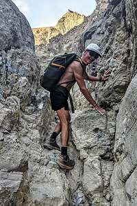 Gower Gulch along the Golden Canyon LoopIt was getting pretty near time for a swim in that lovely pool we were paying for back at Furnace Creek Ranch, but before returning to the hotel, Herb wanted to make one more quick stop to try to find an interesting place he had read about - Cottonball Basin.
The directions to get to it were not very specific - drive 6 miles north of Furnace Creek Ranch, and pull out on the side of the road. Then cross the road and walk 0.6 miles. It was supposed to be a less crowded version of the Badwater Basin, where people love to photograph the bright white salt polygons in the morning light.
We scouted it out and thought we found it, but being mid-day, the lighting was not good. We would have to come back sometime either at sunrise or sunset. I don’t think we were going to have enough sunrises and sunsets in our four days here to cover everything we wanted to photograph.
 Golden CanyonWe headed back to the Ranch for a quick lunch, nap (we were up well before sunrise), and a dip in the lovely Furnace Ranch pool, we headed out for our main event of the day - the Golden Canyon hike, probably Death Valley’s most popular. We had done this hike before, but it was definitely worth a repeat.
Since it was already almost 2:00 pm and the days were so short, we weren’t sure if we would have the time or inclination to go all the way up to Zabriskie Point, but that was okay as we had already been there for both sunset last night and sunrise this morning.
Since the Golden Canyon section of the hike is the most spectacular section of the hike, we decided to do it in reverse, so we would hit it in the golden hour right before sunset. This meant starting off along the trail that ran parallel to Badwater Road for a while before climbing up through a canyon along gravel-filled wash, which is Gowers Gulch.
 Golden CanyonThis time when we got to the junction at 2.3 miles, rather than continuing straight up to Zabriskie point, we took a left at the Badlands Loop Trail, which would bring us back over and down into Golden Canyon for a 4.5-mile loop, ensuring we would get back before dark.
The section over to the top of the Golden Canyon Trail was probably the most dramatic, with its colorful rock formations - Red Cathedral, Manly Peak, and other ones that I didn’t know the names of.
It was hard to keep our eyes on the trail because the scenery was so beautiful, but we had to as there were parts of the way down that were a bit sketchy, with loose scree and steep drop-offs, but nothing too precarious.
.thumbnail.jpg) Golden CanyonWe made good time covering the just under 5 mile loop in just a little over two hours, allowing us to get back to the car while there was still some daylight
Golden CanyonWe made good time covering the just under 5 mile loop in just a little over two hours, allowing us to get back to the car while there was still some daylight
Before heading back to the Ranch, we drove to the Desolation Canyon Trailhead, just off Badlands Road to watch the sunset over the mountains.
Back at the Ranch, we had dinner for a second time at the Last Kind Words Saloon, which had a very nice decor, but mediocre food - I think because of limited choices during Covid.
Last night we had a pepperoni pizza that I was convinced was a reheated DiGiornio and tonight we had a less than inspiring pulled pork sandwich. Let’s just say that we didn’t have many Kind Words for the Last Kind Words Saloon. The outdoor area where we dined, however, was very nice.
Day 3 - Emigrant Canyon Road (Aguereberry Camp and Point) and Mesquite Flat Sand Dunes for sunset
 Aguereberry Mining CampLast night while we were watching the sunset from the Desolation Canyon Trailhead parking area, we noticed a little tiny light flashing up atop the Panamint Range on the other side of the Valley.
Curious to see what it was, I pulled out the Death Valley map and saw that we were directly across from something called 6,433-foot high Aguereberry Point, something I had never heard of before.
 Home Sweet HomeIt sounded like a worthy destination for the day. It was also nearer to Stovepipe Wells, where we would be spending the next two nights.
No sunrise this morning, as we decided it would be nice to sleep in for a change, so after a leisurely morning, we left Furnace Ranch, headed north on 190, drove right past Stovepipe Wells, as it was too early to check in, and made the turn onto Emigrant Canyon Road. After driving 11.6 miles, we turned left onto the dirt Aguereberry Canyon Road.
Just a few miles in, we noticed some structures to our right. Although we couldn’t drive to them, there was a small pull-out on the right. We’ve been to a lot of ghost towns and old mining camps, but this one looked pretty interesting.
It was a very short walk, down a dirt road to what we learned was the Aguereberry Mining Camp and Eureka Mine, established by old-time prospector Shorty Harris and his greenhorn partner Pete Aguereberry in 1905 in order to mine the gold out of the hills behind it.
.thumbnail.jpg) Aguereberry Camp kitchenHerb thought he recognized the name Shorty Harris, and soon enough he eventually remembered that the sculpture at the Goldwell Open Air Museum in Rhyolite with the large prospector wielding a picaxe down on where I had positioned Herb for a photo was called “Tribute to Shorty Harris.” However, Shorty was not the axe-wielding prospector, but the tiny penguin-like figure next to him.
Aguereberry Camp kitchenHerb thought he recognized the name Shorty Harris, and soon enough he eventually remembered that the sculpture at the Goldwell Open Air Museum in Rhyolite with the large prospector wielding a picaxe down on where I had positioned Herb for a photo was called “Tribute to Shorty Harris.” However, Shorty was not the axe-wielding prospector, but the tiny penguin-like figure next to him.
An information board gave us a brief history of Shorty’s and Aguereberry's stay here. When gold was discovered by Harris and Aguereberry in these hills in 1905, they planned a town named Harrisberry, where during its heyday, some 300 miners lived, most in a tent city that sprang up across the road from the house.
Later, as the tale goes, Shorty tried to take credit for the claim, and renamed the town Harrisburg. However, their boom was rather short-lived, and when the mine’s output decreased, Shorty left and most of the rest of the miners left.
 Living room view of other cottageHowever, Pete Aguereberry remained, and worked the mine for some 40 more years until his death in 1945. While all those tents the miners lived in are long gone, the original cabin that he built and lived in is still on the site. The buildings in the front were built in the 1940's as guest houses.
What was so fun about this deserted mining camp was that so many of the structures were still fairly intact, enough to give an idea of what it must have been like to live in them. Plus, you were allowed to wander around in them, which is often not the case. I never would have expected this to be one of my favorite stops in Death Valley, but it was. I love human history mixed in with some natural beauty.
Some of the structures had water heaters, sinks, refrigerators, and stove tops. There was even a two seater outhouse a little ways up on the ridge. I guess he was pretty lonely and wanted to make things nice for his guests so that they would visit.
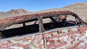 Aguereberry carThink of all the history that went on during his lonely, remote stay from 1905 to 1945 - two World Wars, the Great Depression, the expansion of travel by automobile, etc. Hopefully, his guests filled him in as to what was going on in the world.
To the left of the camp, we saw what looked like a rusted old car. We wandered up that way and sure enough there was an old pretty large car, completely riddled with bullet holes.
The old Eureka Mine was also nearby, but blocked to prevent entry.
Having explored every nook and cranny, we continued up the Aguereberry Point Road, which got a bit rougher, with some narrow sections and blind turns. The last half mile is barely wider than one lane and there is a steep, 1000-foot drop-off, which could get you pretty quickly back to the Valley.
 View from Aguereberry PointPete Aguereberry actually built this road so that his guests could enjoy the wonderful view of the Valley below.
There is a small parking lot at the end of the road, but the view is partially blocked by a ridge. The more panoramic view is reached via a short walk left around the rock formations and then along an informal trail down the ridge to your right. I stopped short before things got scary.
The point overlooked the southern half of Badwater Basin and the area of Death Valley from Furnace Creek north all the way to Salt Creek. It was lovely, but, of course, like everything else, the view would be better at sunrise or sunset. The drive on the windy road, however, wouldn’t, so back we went.
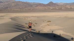 Hiking up the backside of the Mesquite Flat Sand DunesOur room at Stovepipe Wells was still not ready for check-in, so we decided to go straight to the Mesquite Flat Sand Dunes for a sunset hike.
The lighting on the dunes is dependent on the season. In the winter time, which we were now closest to, sunrise is best on the front side of the dunes (by the main parking lot), but sunset is best on the back side, reached via a longer walk from the Historic Stovepipe Well, just off Scotty’s Castle Road, a few miles north of the junction with 190.
So to the back side we would go. After parking near the Historic Stovepipe well, we started walking out towards the dunes which were much lower than the ones seen from the main parking lot.
 Backside of the Mesquite Flat Sand DunesThe sand dunes stretch over 7 miles, so we knew we were not going to get to the main dune area and the tallest “Star Dune.” That would have to wait for sunrise tomorrow when we would hike in from the main parking lot.
It was close to a one mile walk just to get to the beginning of them. Walking was easy however, as much of the surface was hard packed dirt rather than deep sand. We could pick and choose whenever we wanted to go up and over a small dune.
These smaller dunes were beautiful in their own way - less dramatic, but more intimate and peaceful. There wasn’t another soul to be seen for miles. I think very few people explore this section of the dunes.
 Mysterious crater-like features in Mesquite DunesOne of the most interesting features we stumbled upon was a rocky section at the base of several small dunes with two crater-like circles, about 8 feet in diameter. Herb was so intrigued that when we returned home, he sent a photo to the National Park Service to see if he could get an explanation as to what created them. They were unable to do so. It looked to us very much like small meteorites.
Initially, I thought that we might be able to make it to the main dunes and return before sunset, but distances are deceiving in this type of landscape. So, after about 2 miles and an hour of hiking, we decided it was time to return to the car.
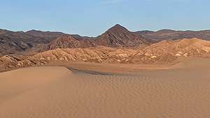 The mountains start to put on their evening showAnother thing about hiking in dunes is that it is easy to get lost if you don’t have a specific landmark in mind to head for. We were also assisted by Strava and Gaia, which we were using to record our hike. Both of these apps provide tracks which allow you to sort of follow the breadcrumbs back home.
Our timing was pretty perfect. We got to watch the sky turn a beautiful pastel pink and blue and the mountains we were heading for take on a golden glow.
 Back to the car just in timeGreat hike. We felt like we were the only people in the world, or at least our small part of it.
Back at Stovepipe Wells, we checked into our room and headed for dinner at the Badwater Saloon, hoping for a better experience than the Last Kind Words Saloon in Furnace Creek. It was. We both had the Toll Road Mushroom Pasta, a tasty dish with mushrooms, of course, roasted sun dried tomatoes, and broccoli, sauteed in a Chardonnay Lemon Cream Reduction topped with Parmesan. It was so nice to see a vegetable again.
Once again, we chose to sit by ourselves outside rather than in the bar - not just because of Covid, but because it was nicer. Plus we could drink our own wine!
Early night. Had to get to the dunes before sunrise!
Day 4 - Sunrise on Mesquite Flat Sand Dunes, Ubehebe Crater hike, and Cottonball Basin at sunset
 Herb "kicking it in"We were up at 5:00 am and in the main parking lot for the Mesquite Flat Sand Dunes to start our hike by 6:00, well positioned to be on top of the tallest “Star Dune” for 6:30 sunrise.
Their easy accessibility - it’s only one mile from the parking lot to the Star Dune - making it the most highly visited dune in the park, if not in all of California.
 View from the Star DuneOnly problem was that there were three parties in front of us, and we wanted to get there first to avoid having people in our photos. Our boys ran cross country in high school and college, so I turned to Herb and pulled out an old commonly used motivational cry: “kick it in Herb!”
Somewhat unsure of whether I was serious or not, he did indeed kick it in, and we did arrive first on top. We acted quickly, as we didn’t have much time before the others would join us.
We got to the top of 130 foot Star Dune, a much easier climb than to the top of Death Valley’s Eureka Dune, which rises 680 feet above the valley floor. We had it to ourselves - well, at least for the next 20 minutes or so.
 Star DuneFrom there we looked down on a series of pyramid-shaped dunes that changed in color from beige to gold as the sun rose. They were absolutely stunning.
Although much smaller than Eureka Dunes, these had their own unique beauty. Hollywood must agree because they have been the setting for several movies, including Star Wars.
We continued on along the ridge, which can be a little disconcerting, as the sides drop off so steeply. However, it is thick sand, so even if we fell, we didn’t think we would roll that far.
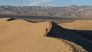 Mesquite Flat Sand DunesYou could walk for hours and hours on this 7-mile long dune system, formed at the convergence of several prevailing winds in the valley. I was glad we got to see the other end of them last night for sunset, as they had quite a different feel to them, being so much smaller.
There is a certain formula needed for creating and maintaining a sand dune. The first ingredient is a source of sand, in this case, the eroding Cottonwood Mountains to the north. Next, you need wind to move the sand and a barrier of some sort to catch it and prevent it from blowing further, in this case, the Panamint Mountains to the south. The conditions at Mesquite Flat Sand Dunes are perfect.
Sun fully up, we returned to the car and then back to the Stovepipe Wells Village Hotel for a nap before our next adventure of the day, which we didn’t know what that would be yet.
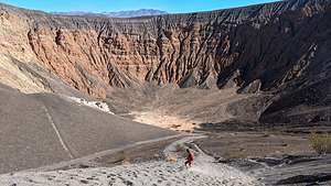 Lolo descending into Ubehebe CrateDespite it being an hour away, we decided to take the drive up to Ubehebe Crater to catch the late afternoon light and to hike down to the bottom, which we had done before about 7 years ago.
At a half-mile wide and 600-feet deep, it is quite impressive. It was formed by volcanic explosions several thousand years ago.
To experience it, you actually don’t have to venture too far from your car, because you actually pull right up to its rim (or about 20 feet back) from the parking lot. You don’t even have to leave y our car, but of course that was not our plan.
A very steep trail down into the crater starts right in front of the parking lot. A slightly longer and more gradual trail (but still very steep) starts about 500 feet to the left when facing the crater.
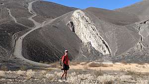 Herb inside the CraterIt is very gravelly. Last time Herb made the mistake of wearing sandals and had to turn back after about 100 feet because there was so much gravel shoved under his toes.
Even with proper foot gear, we slipped and slid for about a quarter of a mile before arriving at the bottom, which was 600-feet lower than the rim.
It really was pretty awesome standing on the flat floor of the crater looking up at its steep, multicolored walls. As with so many other places in this park, it was eerily silent. Quiet is good around a volcano.
We spent some time at the bottom, even climbing up onto a white rock protruding out of the gravel on one of its sides.
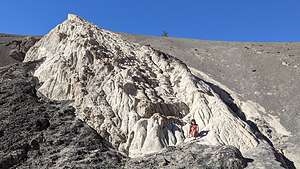 Inside the Ubehebe CraterWhen it was time to leave, we selected the longer path that had a slightly shallower incline. Still, it was a pretty tough hike, made all the more difficult by the loose cinder surface - two steps forward, one step back. It was not for the feint of heart.
Before heading out on the round-the-rim hike, we decided to set up our chairs at the edge of the rim and eat our lunch. The sandwiches were good, the setting was even better.
After lunch, we set out on the other hiking option at Ubehebe Crater - the 2.25-mile hike around the rim of Ubehebe Crater, including a short side trip to Little Hebe Crater. Nice, but I think descending down into the crater was more fun.
 Lunch at the RimAll in all we hiked about 3.1 mile down, up, and around the Crater.
When we got back to the car we saw that there was a photo workshop going on, and it was the same group that we saw a few days back at Zabriskie Point sunrise. We spoke to the group leader and found that she also lived in Santa Rosa, where we lived. She seemed familiar and soon we made the connection. She was one of the judges in Herb’s photography club competitions. Small world, or maybe not so small, as good photographers tend to visit the same places.
She did confirm that Cottonball Basin, which we visited during mid-day yesterday, can be a very interesting photographic spot at sunrise and sunset. So, on our way back to Stovepipe Wells, we followed the directions she gave us as to where to pull-out on the road, including the mile marker, which I can’t remember now, but it was about 6 miles north of Furnace Creek Ranch.
 Cottonball BasinAfter parking at the designated spot, we walked out onto the flats, which was sort of a less crowded version of the Badwater Basin, where people love to photograph the bright white salt polygons in low light.
It was much nicer than when we had been there in mid-day, as now the mountains had taken on a golden hue and were reflected in the rivulets running through the salt flats.
It had been another full day. Time to get back to our home for the night at the Stovepipe Wells Village Hotel and dinner at the Badwater Saloon. This time we both had Angus Burgers, which were tasty, and ate once again at our outdoor table with our own bottle of wine.
Day 5 - Mosaic Canyon hike, Father Crowley Viewpoint, and departure
 Mosaic CanyonThis was our last day in Death Valley before heading onto Bishop where we would spend a few days with our son and daughter-in-law. Since they were working until 5:00, that gave us time for one more hike.
The obvious choice was nearby Mosaic Canyon, considered by many to be Death Valley’s best hike, or at least a close contender to Golden Canyon. Mosaic is more of a slot canyon compared to Golden with much narrower passageways and rocks to scramble over.
The trailhead is at the end of Mosaic Canyon Road, a 2-mile dirt road (navigable by most passenger cars) just across the street from the Stovepipe Wells Campground.
 Mosaic CanyonAfter parking, we headed into the mouth of Lower Mosaic Canyon, a narrow slot that weaves its way between wavy white walls of water-polished white marble and blue-gray conglomerate rocks.
The reason the marble is so polished in this canyon, as opposed to other canyons in Death Valley, is that the ground is much more gravely. During flash floods, the fast moving water mixes with the gravel, scouring the sides of the canyon walls, or “polishing” it. As a result, this rock is very slippery, so we had to be careful when scrambling over it.
The conglomerate rocks get water polished as well, giving them the appearance of mosaic tiles grouted into the canyon wall, hence the name Mosaic Canyon.
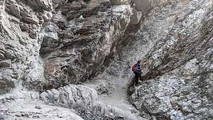 Mosaic Canyon - end of the roadThe best examples of polished marble occur in the first quarter mile into the hike, so you could turn around here and still consider it a wonderful hike.
At about a half mile, the canyon opened up to an expansive gravel wash, marking the top of the lower canyon, and the place where many people turn around, making it a very rewarding, short 1-mile hike.
The last time we hiked this trail, we did turn around, but this time we decided to continue on, and we are so glad we did.
From this point on, the canyon narrowed again and there were more examples of the “mosaic” conglomerate rocks on the canyon walls. Also, there were more and more boulders providing obstacles to climb over.
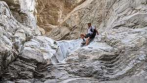 Mosaic Canyon - what goes up, must come downEventually, we came to a 20-foot dry falls totally blocking our passage. We thought we were done until we noticed a bypass around it that was still pretty sketchy but doable. With a little boost from Herb, I was up and around the obstacle. I think many people do (and should) turn around at this point.
Whenever I climb up something precarious, I always try to think about whether I can come back down, as that is always more difficult than up.
At the two mile point, we really came to the end of the road at a 30-foot dry falls. Time to turn around, this time maneuvering down the slippery boulders.
.thumbnail.jpg) Father Crowley View PointWhat a fantastic hike - just a little over 4 miles with a 937-foot elevation gain. Great ending to a truly wonderful trip to Death Valley, with some new sights as well as some old favorites.
Father Crowley View PointWhat a fantastic hike - just a little over 4 miles with a 937-foot elevation gain. Great ending to a truly wonderful trip to Death Valley, with some new sights as well as some old favorites.
We left the park via Highway 190 West, through Panamint Springs, towards the town of Lone Pine, but first a quick stop at the Father Crowley View Point.
Father Crowley is a well-known and admired man, who recognized the beauty of the Eastern Sierra and Death Valley and did so much to promote it in the early 1900s. His name has been memorialized in such places as Crowley Lake in Bishop and this viewpoint to name a few.
In the 1930s, Father Crowley, a catholic priest, was responsible for ministering to the people of Inyo County, which included Death Valley. Nicknamed the Desert Padre, we would often stop at this point to admire the view when returning to his home in Lone Pine after visiting his parishioners in Death Valley.
 Bulbous formations in the Alabama HillsFrom the viewpoint, there is a stunning view into the colorfully-striped Rainbow Canyon and out across the Panamint Valley.
Seemed as good a place as any to have a late picnic lunch.
When we got to Lone Pine, we still had some time to kill before getting to Andrew and Celeste’s so we decided to take a drive along Movie Road through the Alabama Hills, one of our favorite places in the Eastern Sierra.
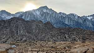 Sun sinking behind Mt. WhitneyIt’s a truly beautiful place with oddly-shaped boulders and towers set against the backdrop of Mount Whitney (the tallest mountain in the continental U.S.). For people our age, some of the scenery in the Hills might even be familiar from watching old Westerns. Hollywood filmmakers discovered this dramatic scenery back in the 1920s and filmed hundreds of movies (particularly westerns), TV shows, and commercials here, such as “How the West was Won,” “Rawhide,” and “Gunga Din.” And, it’s not just about old westerns. Plenty of current day movies, such as “Gladiator,” “Django Unchained,” and the new Lone Ranger have used the surrounding hills as a set as well.
Mt. Whitney, the tallest mountain in the continental United States, was already starting to block the sun by 3:30, so we didn’t have much light left by the time we got there.
Okay, enough stalling. Time to get on to Bishop for some big hugs and fun with Andrew and Celeste.
- ‹ previous
- 3 of 4
- next ›
Death Valley National Park location map in "high definition"
Javascript is required to view this map.
