- Home
- About
- Map
- Trips
- Bringing Boat West
- Migration West
- Solo Motorcycle Ride
- Final Family XC Trip
- Colorado Rockies
- Graduates' XC Trip
- Yosemite & Nevada
- Colorado & Utah
- Best of Utah
- Southern Loop
- Pacific Northwest
- Northern Loop
- Los Angeles to NYC
- East Coast Trips
- Martha's Vineyard
- 1 Week in Quebec
- Southeast Coast
- NH Backpacking
- Martha's Vineyard
- Canadian Maritimes
- Ocracoke Island
- Edisto Island
- First Landing '02
- Hunting Island '02
- Stowe in Winter
- Hunting Island '01
- Lake Placid
- Chesapeake
- Provincetown
- Hunting Island '00
- Acadia in Winter
- Boston Suburbs
- Niagara Falls
- First Landing '99
- Cape Hatteras
- West Coast Trips
- Burning Man
- Utah Off-Roading
- Maui
- Mojave 4WD Course
- Colorado River Rafting
- Bishop & Death Valley
- Kauai
- Yosemite Fall
- Utah Off-Road
- Lost Coast
- Yosemite Valley
- Arizona and New Mexico
- Pescadero & Capitola
- Bishop & Death Valley
- San Diego, Anza Borrego, Joshua Tree
- Carmel
- Death Valley in Fall
- Yosemite in the Fall
- Pacific Northwest
- Utah Off-Roading
- Southern CA Deserts
- Yosemite & Covid
- Lake Powell Covid
- Eastern Sierra & Covid
- Bishop & Death Valley
- Central & SE Oregon
- Mojave Road
- Eastern Sierra
- Trinity Alps
- Tuolumne Meadows
- Lake Powell Boating
- Eastern Sierra
- Yosemite Winter
- Hawaii
- 4WD Eastern Sierra
- 4WD Death Valley +
- Southern CA Deserts
- Christmas in Tahoe
- Yosemite & Pinnacles
- Totality
- Yosemite & Sierra
- Yosemite Christmas
- Yosemite, San Diego
- Yosemite & North CA
- Seattle to Sierra
- Southwest Deserts
- Yosemite & Sierra
- Pacific Northwest
- Yosemite & South CA
- Pacific Northwest
- Northern California
- Southern Alaska
- Vancouver Island
- International Trips
- Index
- Tips
- Books
- Photos/Videos
- Search
- Contact
Goblin Valley State Park, UT
Tuesday, July 17, 2007 - 8:00am by Lolo
374 miles and 7 hours from our last stop - 1 night stay
Travelogue
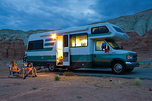 Parents with Lazy Daze in Campground - AJGGoblin Valley had been on my list of places to visit ever since I first saw it’s otherworldly mushroom-shaped rock formations in the , but it is so remote and off the beaten track that we just never got around to visiting it before. Let’s just say that it’s not the kind of place you stop at along the way, because it literally is on the way to nowhere. It requires a 14 mile out and back drive through some very desolate countryside.
We almost missed the turnoff; in fact, we actually did miss the turnoff and then had to retrace our steps back several miles to find it again. Our mistake was relying on our GPS to tell us when to turn rather than doing it the old-fashioned way of just looking for a turnoff sign. When our GPS finally did tell us in its smug little monotone voice that it was time to turn right, we just stopped dead right in the middle of Highway 24 and looked to the right across an expanse of seemingly endless desert and sagebrush.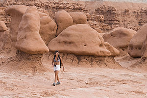 Lolo hiking among the goblins There was no road in sight—not even one of the bumpy washboard variety that Utahians like so much. I was really disappointed. I really wanted to get there this time. We thought we remembered seeing a sign (that we hadn’t bothered to read) a few miles back so we made a U-turn and drove back about 5 miles. Sure enough, there it was: Temple Mountain/Goblin Valley Junction. We made the turn and crossed our fingers that it would be paved. Thankfully, it was. In fact, the last 9 miles or so of road looked brand new.
Our first stop was the Observation Shelter where there was a wonderful view out over the entire valley, which is literally chock full of hundreds of the strange rock formations that give goblin valley its name. I kind of thought they looked more like mushrooms or giant phalluses, but I can see why the state of Utah went with the name Goblin Valley instead of the alternatives.
I must admit that we have gotten a bit jaded after visiting so many spectacular places like Bryce Canyon, Monument Valley, Badlands, and such, that it’s really difficult for a rock formation to “wow” us at this point. However, that being said, the “goblins” were very cute and being able to walk amongst them and get up close and personal gave a quite enjoyable and intimate feel to the place.
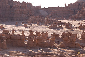 Goblin Valley in morning lightWe took the short path from the Observation Shelter parking area down into the Valley and wandered aimlessly amongst the goblins. There really was no specific trail to follow, so we just kind of randomly headed towards any formation that captured our fancy. Fortunately, you can’t really get lost because the Observation Shelter is visible from almost any point.
After hiking and photographing for a bit, we headed towards the campground, which was only a short drive from the Observation Shelter. We were very pleased when we saw it. It was just what we look for in a campground—empty and great views. There were 25 sites (only 5 of which were occupied), and each had a paved parking pad and a very welcomed shade covering over the picnic table. Although there were no goblins here, I think the scenery was even better than the valley. The campground was set in an amphitheater of multi-colored badlands that got even more colorful as the sun got low.
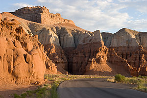 Goblin Valley Campground at sunriseI immediately grabbed a book and plopped my butt in a beach chair in the shade. It was amazingly comfortable considering it was about 100°F. The boys went for a run out on the Curtis Bench Trail which led from the campground along a ridge overlooking the valley. Although they couldn’t find the spur trail down into the valley, they did manage to see an incredible sunset over it. I was kind of jealous that I missed it, but that beach chair sure was comfortable.
The evening cooled down nicely as it always seems to in the desert, and we had a very enjoyable BBQ under the stars. It’s amazing how many more stars you can see here than nearer to civilization.
The next morning we rose early so as to not miss the morning light on the badlands. It did not disappoint. After taking some more photos, we headed out on our way towards Lake Mead where we had a campsite and a ski boat waiting for us..
Description
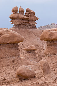 Random goblinsGoblin Valley State Park is one of Utah’s remote hidden treasures. The valley, which is only about a mile across and two miles long, is full of thousands of mushroom-shaped rock formations that resemble goblins. These pinnacles, which are only a few meters high, are composed of large, reddish-brown boulders which sit atop weaker sandy layers that have eroded away more quickly. The formations are nearly as dramatic as those in the more popular National Parks, but on a smaller scale and without the crowds.
To reach the park, follow Utah Highway 24 south from I-70 (about 10 miles west of the town of Green River) for about 30 miles and then turn right at the Temple Mountain/Goblin Valley Junction. Travel west on that road for about 5 miles, and then turn left. The road, which is now paved, continues another 9 miles to the park entrance.
After you enter the park, stop at the covered Observation Shelter for a wonderful view of the Goblin Valley. The view is particularly spectacular at dusk. From here you can walk down on short, easy footpaths and wander amongst the Goblins. Although there are supposedly trails from the parking lot, they are not obvious. Fortunately, you can just wander pretty much anywhere you want along the valley and then just hike back up to the Observation Shelter.
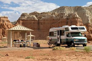 Goblin Valley CampgroundThe heat is an issue in summer, with an average between 90 and 105°F. Fortunately, evenings cool off to about 50°F making camping comfortable. Also, summer is monsoon time, with frequent severe thunderstorms in the afternoon, so hikers must take caution.
Facilities in the park include a 25-site campground with modern restrooms and hot water showers. Each campsite has a picnic table with a shade covering, paved parking pad, and barbecue grill.
- ‹ previous
- 4 of 19
- next ›
Goblin Valley State Park location map in "high definition"
Javascript is required to view this map.

What a wonderful site you have here! I have been exploring and reading it all day!
We have been to Goblin ,very eerie spot. It was so windy when we arrived we could not set up the tent, so we opted to sleep in the steel tent (van) Took some amazing night pic's,I hiked back just south of the grounds(50yrds) that night with a coleman lantern behind the fomations and set it on the ground. Walk back to our site and with my old Cannon AE-1 on a tripod with slide film and took some very impressive time lapsed pic's with just star light and the lantern,I'll have to dig those out.
I really want to post a comment on your trip back through Ely Nev.but was unable to.
I worked in the Oil exploration business in the early 80's and we had a base in Ely.
To avoid any large ruts on the BLM lands about 80 miles south of town ( from our large sismic vibrator trucks)we would leave town at 1:00am and drive south past Wheeler Peak to the frozen turda. Almost every night we would encounter a large herd of Elk crossing the highway right by the pass.It was very impressive.
On one day off ,a fellow worker and I snow-shoed up the west slope to Wheeler Peak!
It took us 8 hrs to the summit and 2 1/2 back down,plunging all the way down!
Hope you enjoy this post Thanks Tom
Thanks Tom and Dianna,
We really enjoyed Goblin too. I definitely want to get back there and explore a bit more.
Wheeler Peak and Ely is another place that we didn't have enough time to fully explore. I'll be sure to try to make the climb on our next trip out west!
Safe travels - Herb
Sounds like a wonderful spot.
So far, my favorite has been gooseneck state park. Itsa 'bout 18 miles down a dirt/gravel road off the 2 lane from moab to monument valley. The river, I think it's the st joseph? makes a few "gooseneck turns" there. the campground area is large and flat, park anywhere you want. the river is 1500 feet down that cliff over there....
While we were there, there was a navajo woman selling jewelry our of her blue minivan....
I think we bought a hundred bucks worth.
So much for "free camping" hehe.
Jim
I think I know this park, and definitely want to get there next time. As I recall, the dirt/gravel road did not look very inviting for the RV, but I know the views and photographic possibilities have got to be incredible.
Herb
We did it in a 40 foot diesel pusher towing a wrangler. Hard packed dirt, not much bumpy, good road.
The park was just amazing. Nothing there at all, except a flat spot at the edge of the cliff. We parked as near the edge as I dared, and took dibs of the best picnic table.
A few yards away, a navajo woman was making and selling her jewelry out of an old minivan. We spent about $200 I think, made her day.
Throughout the day, the tourists would drive in, circle the parking lot, read the plaques, snap a few pictures, and drive away...
When the sun started setting, it was like being in another world. And the quiet of the morning was amazing.
Jim
Wow! - Makes me wish we had given it a try... Although, since it wasn't a planned stop, we probably didn't have the time in the schedule anyway.
Definitely will check it out on our next trip out there.