- Home
- About
- Map
- Trips
- Bringing Boat West
- Migration West
- Solo Motorcycle Ride
- Final Family XC Trip
- Colorado Rockies
- Graduates' XC Trip
- Yosemite & Nevada
- Colorado & Utah
- Best of Utah
- Southern Loop
- Pacific Northwest
- Northern Loop
- Los Angeles to NYC
- East Coast Trips
- Martha's Vineyard
- 1 Week in Quebec
- Southeast Coast
- NH Backpacking
- Martha's Vineyard
- Canadian Maritimes
- Ocracoke Island
- Edisto Island
- First Landing '02
- Hunting Island '02
- Stowe in Winter
- Hunting Island '01
- Lake Placid
- Chesapeake
- Provincetown
- Hunting Island '00
- Acadia in Winter
- Boston Suburbs
- Niagara Falls
- First Landing '99
- Cape Hatteras
- West Coast Trips
- Burning Man
- Utah Off-Roading
- Maui
- Mojave 4WD Course
- Colorado River Rafting
- Bishop & Death Valley
- Kauai
- Yosemite Fall
- Utah Off-Road
- Lost Coast
- Yosemite Valley
- Arizona and New Mexico
- Pescadero & Capitola
- Bishop & Death Valley
- San Diego, Anza Borrego, Joshua Tree
- Carmel
- Death Valley in Fall
- Yosemite in the Fall
- Pacific Northwest
- Utah Off-Roading
- Southern CA Deserts
- Yosemite & Covid
- Lake Powell Covid
- Eastern Sierra & Covid
- Bishop & Death Valley
- Central & SE Oregon
- Mojave Road
- Eastern Sierra
- Trinity Alps
- Tuolumne Meadows
- Lake Powell Boating
- Eastern Sierra
- Yosemite Winter
- Hawaii
- 4WD Eastern Sierra
- 4WD Death Valley +
- Southern CA Deserts
- Christmas in Tahoe
- Yosemite & Pinnacles
- Totality
- Yosemite & Sierra
- Yosemite Christmas
- Yosemite, San Diego
- Yosemite & North CA
- Seattle to Sierra
- Southwest Deserts
- Yosemite & Sierra
- Pacific Northwest
- Yosemite & South CA
- Pacific Northwest
- Northern California
- Southern Alaska
- Vancouver Island
- International Trips
- Index
- Tips
- Books
- Photos/Videos
- Search
- Contact
Jawbone to Lake Isabella 4WD Road, CA
Friday, October 4, 2019 - 10:00am by Lolo
170 miles and 7 hours from our last stop - 1 night stay
Travelogue
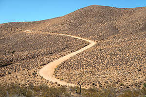
 Along the Jawbone Canyon to Lake Isabella 4WD RoadWe were pretty much committed at this point to the southern route home from Bishop, which would bring us to Bakersfield and then up I5, but Herb wanted to do it in a more creative way, via the 50-mile (and 4 to 5 hours of bouncing) Jawbone to Lake Isabella 4WD road - another “Easy” route according to our off-roading gude.
Our route from Lone Pine brought us along Highway 14 past the reddish desert cliffs and spectacular rock formations of Red Rock Canyon State Park, which we had had the good fortune to explore last year.
However, today we would go a short distance past the Canyon and turn onto Jawbone Canyon Road, where we would begin our journey up and over the Piute Mountain Range.
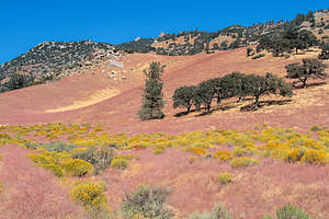
 The lovely colors along Jawbone Canyon RoadThe road began in an OHV (off-highway vehicle) area, where many come to play on the crazy steep hills and rocky terrain. We, however, were going to skip that and just drive the Jawbone Canyon Road.
The drive took us through several climatic zones, starting in the semi-arid foothills of the Mojave Desert and climbing, first past Joshua trees, then pinyon pines and junipers, and finally oak woodlands and conifers.
In about 13 miles we descended into Kelso Valley before turning west and ascending from 2,500 feet to over 8,000 feet along a series of steep and narrow switchbacks up and over the Piute Mountains inside the Sequoia Natioal Forest.
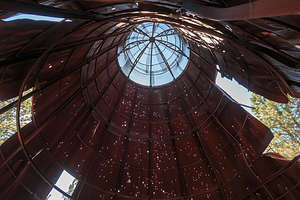
 Dilapidated old sawmill chip burner now used for target practiceWe stopped for lunch at a rusty teepee-like structure that was once a chip burner from an old sawmill. I believe now its purpose is target practice as it was riddled with bullet holes. Time to move along.
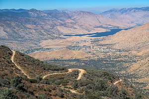
After about another 6 miles we began our exciting descent to Lake Isabella along a very dramatic and steep series of switchbacks with occasional steep dropoffs.
Finally, after 5 hours, we reached the paved Bodfish Road. Whew!
Herb was too exhausted with driving to even consider driving the remaining 7 hours it would take to get home, so we decided to look for a place to camp along the Kern River, which was on the way to Bakersfield along Route 178.
 Twisty road down to Lake IsabellaHerb had heard about a nice hot spring along the Kern River called Remington Hot Springs. We turned off 178 onto Kern CAnyon Road to check it out. After walking down a very steep hill from the parking area to the river, we came upon what I expected to find on a Friday late afternoon -- two pools filled with about a dozen people half or a third our age. We decided to skip the soaking and go back to the Sandy Flat Campground, which we had passed a few miles back on the Kern Canyon Road.
We managed to get a site in an already pretty full campground. It was nice enough and had access to the river. We both were pretty tired and ready to be home, so we made it an early evening so we could get an early start in the morning.
- ‹ previous
- 4 of 5
- next ›
Jawbone to Lake Isabella 4WD Road location map in "high definition"
Javascript is required to view this map.
