- Home
- About
- Map
- Trips
- Bringing Boat West
- Migration West
- Solo Motorcycle Ride
- Final Family XC Trip
- Colorado Rockies
- Graduates' XC Trip
- Yosemite & Nevada
- Colorado & Utah
- Best of Utah
- Southern Loop
- Pacific Northwest
- Northern Loop
- Los Angeles to NYC
- East Coast Trips
- Martha's Vineyard
- 1 Week in Quebec
- Southeast Coast
- NH Backpacking
- Martha's Vineyard
- Canadian Maritimes
- Ocracoke Island
- Edisto Island
- First Landing '02
- Hunting Island '02
- Stowe in Winter
- Hunting Island '01
- Lake Placid
- Chesapeake
- Provincetown
- Hunting Island '00
- Acadia in Winter
- Boston Suburbs
- Niagara Falls
- First Landing '99
- Cape Hatteras
- West Coast Trips
- Burning Man
- Utah Off-Roading
- Maui
- Mojave 4WD Course
- Colorado River Rafting
- Bishop & Death Valley
- Kauai
- Yosemite Fall
- Utah Off-Road
- Lost Coast
- Yosemite Valley
- Arizona and New Mexico
- Pescadero & Capitola
- Bishop & Death Valley
- San Diego, Anza Borrego, Joshua Tree
- Carmel
- Death Valley in Fall
- Yosemite in the Fall
- Pacific Northwest
- Utah Off-Roading
- Southern CA Deserts
- Yosemite & Covid
- Lake Powell Covid
- Eastern Sierra & Covid
- Bishop & Death Valley
- Central & SE Oregon
- Mojave Road
- Eastern Sierra
- Trinity Alps
- Tuolumne Meadows
- Lake Powell Boating
- Eastern Sierra
- Yosemite Winter
- Hawaii
- 4WD Eastern Sierra
- 4WD Death Valley +
- Southern CA Deserts
- Christmas in Tahoe
- Yosemite & Pinnacles
- Totality
- Yosemite & Sierra
- Yosemite Christmas
- Yosemite, San Diego
- Yosemite & North CA
- Seattle to Sierra
- Southwest Deserts
- Yosemite & Sierra
- Pacific Northwest
- Yosemite & South CA
- Pacific Northwest
- Northern California
- Southern Alaska
- Vancouver Island
- International Trips
- Index
- Tips
- Books
- Photos/Videos
- Search
- Contact
Kailua-Kona (Big Island), HI
Wednesday, January 10, 2018 - 5:30pm by Lolo
0 miles and 0 hours from our last stop - 4 night stay
Travelogue
Day 1 - Arrival on the Big Island, stocking up at Costco, and checking into Castle Kona Bali Kai in Kailua-Kona
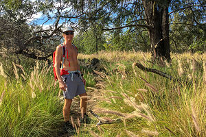 The Pu’u Wa’awa’a cinder cone hike beginsA trip to Hawaii definitely made more sense now that we had moved to the West Coast. The flight from San Francisco is under 6 hours and you even gain 3 along the way. There was still plenty of day left upon our arrival.
After picking up our rental car, we stopped at a Costco on our way to our condo in Kailua-Kona to stock up for our week on the Big Island. Theoretically, our accommodations in Kailua had a kitchenette. I certainly hoped so, because if not, we were going to have a lot of food to figure out what to do with.
We continued on Castle Kona Bali Kai, where we had booked a condo for the next four days. When we arrived, the office was already closed, but we followed the instructions for late check-ins and eventually found our condo.
Although a bit tired looking, the condo was well furnished and equipped with a full kitchen, complete with refrigerator, oven and stove, microwave, and coffee machine. The best part was the location. We were right on Alii Drive, the main drag through Kailua, and we had a view of the ocean and sunset from our deck.
Exhausted from our travels, we ate a quick dinner and hit the sack.
Day 2 - Hike to the top of Pu’u Wa’awa’a cinder cone and Kapuna Beach
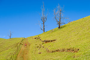 Trail to the top of the Pu’u Wa’awa’a cinder coneAlthough Herb and I love relaxing on a beautiful beach as much as the next guy, we think of that more as a reward after a day of physical activity. Fortunately, the “Hawaii The Big Island Revealed” book gave us plenty of suggestions on good hikes.
So, we would start our Hawaii vacation with a vigorous 7 ½ mile hike to the top of a cinder cone in Pu’u Wa’awa’a Cinder Cone State Park, about 20 miles north of Kailua on the inland Highway 190, between mile markers 21 and 22.
I don’t think I will every be able to remember the name of this cinder cone - it’s amazing what can be done with just the letters a, p, u, and w. Anyway, Pu’u Wa’awa’a literally means “many-furrowed hill,” because of the many apparent wrinkles running down its side. In actuality it looks more like an upside-down jello mold. I wonder how that would be translated in Hawaiian?
This particular cinder cone was created about 100,000 years ago when the nearby Hualalai Volcano (one of the Big Island’s five volcanoes) erupted, spewing blobs (“cinders”) of lava high in the air, which then fell around the opening to the volcano, forming a circular, or oval, “cinder” cone. It’s easy to recognize a cinder cone, because they are always symmetrical (before erosion anyway), with slopes between 30–40°.
 Interesting tree on Pu’u Wa’awa’a summitWe have hiked many cinder cones in our day, mostly in the Pacific Northwest and down into northern California, the other area you can find volcanoes in the U.S.
The hike was great, about 7.5 miles out and back with an 1,800 foot elevation gain. It took us through a forest, along hillsides with grazing sheep, goats, and cattles, and eventually up to the soft grassy summit of the cinder cone, where there are breathtaking views of Mauna Loa, Mauna Kea, and Kohala.
After the hike we continued north on Highway 190 and then took the Waikoloa Road West to the Kohala coast, in search of a beach to spend the rest of the afternoon. The Big Island of Hawaii has so much lava on it, that sandy beaches are fairly hard to come by; and when there is one, a giant resort has usually claimed it. However, they are required to provide public access. Unfortunately, that access is somewhat limited by the number of parking spaces provided.
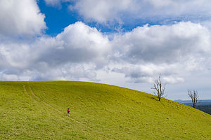 Hike up Pu’u Wa’awa’a cinder coneWe first tried to go to Mauna Kea Beach, which came highly recommended as a classically perfect beach in our “Hawaii Revealed” book, but were unable to obtain one of its highly coveted 40 parking spaces.
Thwarted, we headed back out to the Queen Ka’ahumanu Highway, which runs along the coast, and drove south a few miles before turning into Hapuna Beach, another “perfect” beach according to “Hawaii Revealed”. Since this is a State Recreation Area, rather than a resort, there was ample parking ($5), restrooms, showers, and a picnic area.
Hapuna Beach is lovely, with a half mile of golden sand and great waves for boogie boarding. I can see how people visiting the Hawaiian islands are tempted to do nothing but relax on its incredible beaches. We were going to have to try hard to resist their lure.
Day 3 - Aborted hike to the Golden Pools of Ke-awa-iki and Anaeho’omalu Beach
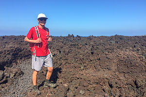 Lava Trail to Keawaiki BeachAs I mentioned in the Trip Overview, there were several calamities and mishaps that challenged the fun and relaxation we had hoped to achieve on this trip. Let’s just say that we wouldn’t have been surprised if we were attacked by locusts at some point.
The first of our challenges started on Day 3 - actually technically in the wee hours of the morning between Day 2 and 3. It seemed that Herb had picked up some sort of stomach virus - probably on the plane - and had spent the entire night in the bathroom experiencing, as he described it, the equivalent of a colonoscopy prep. He looked and felt terrible.
I suggested we just hang around the condo for the day, but Herb insisted that we forge on with our original plans for the day. That plan, unfortunately, included a hike, not a long one, but still Herb looked barely capable of getting to the car.
Undaunted, we drove north along the Kohala coast to the trailhead for the hike to the Golden Pools of Ke-awa-iki, just north of mile marker 79 on the Queen Ka’ahumanu Highway highway (Hwy 19). The hike, which, if completed, would have been 4 miles round-trip, began along an a’a lava trail, which led to the ocean. From there one can choose from a white sand beach on one end or a black sand beach on the other, as well as explore some tide pools.
This was far too ambitious a plan for someone as sick as Herb, so we turned around once we go to the end of the lava trail at Keawaiki beach. We would have to adjust to the situation at hand - perhaps, lying still on a beach (near a restroom) would be a more appropriate activity for the day.
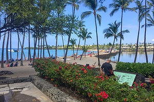 Anaeho’omalu BeachWe drove a little further up the Queen Ka’ahumanu Highway and turned right on Waikoloa Beach Road to get to Anaeho’omalu Beach, which according the “Hawaii Revealed,” is another picture-perfect beach - of course it is. This is Hawaii after all, and every beach is picture perfect.
As expected, the beach was beautiful. I only regret that Herb didn’t get to enjoy it, as he spent most of the time curled up in a fetal position on his beach towel. I tried not to have too good a time frolicking by myself in its warm, tranquil waters. Unlike Hapuna Beach where we were yesterday, this beach has no big surf, because it is protected by an offshore reef.
Right behind us, there were two large fishponds surrounded by palm trees, once used by ancient Hawaiian royalty for raising mullet. To maximize the yield, the opening to the pond was covered with a grate that would allow small fry to enter from the ocean, but not allow these same small fry that fattened up on algae and shrimp in the pond to get out again. Not exactly sporting, but effective.
Herb really didn’t look good, so I drove back to the condo while he slept. Once he was comfortably tucked in bed, I went out for a 6 ½ mile exploratory run along Alii Drive.
Hopefully, tomorrow would be a better day.
Day 4 - Incoming Ballistic Missile Alert, Hikiau Heiau, Pu'uhonua O Honaunau National Historical Park, and snorkeling in Honaunau Bay
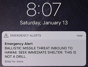 Bad way to start a morningThen again, maybe not. Herb was still sick as a dog, and just as I was getting ready to go out for a run, sirens when off, and I received the following text message:
Emergency Alert:
BALLISTIC MISSILE THREAT INBOUND TO HAWAII. SEEK IMMEDIATE SHELTER. THIS IS NOT A DRILL.
Seriously?
We didn’t know what to think or do. In retrospect, I’m surprised we weren’t panicking more. I think we really didn’t believe it was real, despite the “THIS IS NOT A DRILL” portion of the alert. For all we knew, every time North Korea tested a missile, this is what happened. Besides, if it was true, there was nothing we could do about it anyway.
However, in these traumatic situations, you have to feel like you are doing something. So, we closed the drapes and went into the bedroom. That should do it.
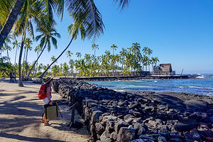 Pu'uhonua O Honaunau National Historical ParkFor the next 38 minutes we waited for I’m not sure what. I can’t believe it took them that long to correct the mistake! Fortunately, by searching the internet, we knew in about 20 minutes that the alert was false. Still, much too long to ponder the thought of our imminent deaths. This was taking my announcement to friends before leaving on this trip that “Hawaii will be my last state” a little too literally.
Well, it did put Herb’s stomach virus back in perspective. He was up and ready to seize the day, because we almost didn’t have one.
We decided to spend the day exploring Kailua-Kona -- perhaps visiting a few human sacrifice temples to cheer us up. Somehow, we missed the turnoff for the Captain Cook Monument on Kealakekua Bay, but did manage to find the Hikiau Heiau at Napo’opo’o Beach, an ancient temple used for human sacrifice and the site where Captain Cook first landed in 1778.
When Captain Cook arrived, the natives thought he was the returning of Lono, their god of agriculture, and honored him with a feast. Unfortunately, afterwards things made a serious turn for the worse. After Cook left, a mast broke on his ship and he was forced to return to have it repaired. A dispute over one of his rowboats being stolen by a native got a bit tense, and Cook was stabbed to death in the conflict.
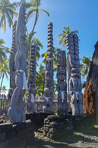 Modest godsToday all that remains of Hikiau Heiau is a raised platform of stacked lava rock, as dark as its history. A smaller stone platform is built on top of the main platform and is believed to have been the location of the lele (altar).
After that cheery stop, we continued on to Pu'uhonua O Honaunau National Historical Park, also called Place of Refuge to learn more about the history and culture of the Hawaiian people. What was nice about this place is that instead of being a place of human sacrifice, it was a place for human forgiveness.
To understand why there was a need for a Place of Refuge, one needs to know a little bit about the kapu, the set of rules and prohibitions in Hawaiian traditional culture and religion. Some examples of kapu were men and women could not eat together, citizens were not allowed to have their shadows fall across a chief, and even commoners were not allowed to surf in the chief’s surfing spot.
The punishment for an offense that was kapu was immediate death - either by club, strangulation, fire, or spear. The reason justice was applied so quickly was that native Hawaiians believed that the gods retaliated against kapu breakers with such fun things as volcanic eruptions, tidal waves, droughts, etc. Therefore, they tried to eliminate the problem before the gods had a chance to act.
However, there was one Get-out-of-jail-free card. If someone that violated kapu could get to a pu’uhonua (place of refuge) before getting captured, they were offered asylum. All they had to do was perform certain rituals to be forgiven.
Pu'uhonua O Honaunau was one of these sanctuaries for violators of kapu. It was made into a national park in 1961. The Park includes a remarkable stone wall, called the Great Wall built in 1500. It is 1,000 feet long, 10 feet high, and 17 feet thick. Also, on the grounds are reconstructed Hawaiian houses and temples, as well as wood carvings of gods. It’s a lovely place to take stroll, especially near sunset.
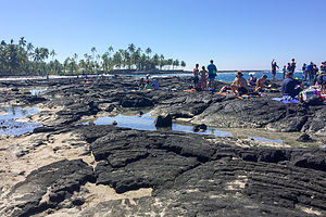 Snorkeling beach near Pu'uhonua O Honaunau National Historical ParkAdjacent to the National Park, but not part of it, is a lava beach on Honaunau Bay, known for its good snorkeling. Before leaving on this trip, I had insisted that we pack our snorkeling gear, so we wouldn’t have to run around trying to rent gear when we needed it. This pushed us over into checked bag territory, which Herb wanted to avoid, so I figured I better get out there and snorkel to justify the extra luggage. Herb was still too under the weather.
I’m a big chicken in the water, so it was a big deal for me to go it alone -- well, not exactly alone as there were dozens of other people doing it, but I didn’t have my own personal snorkel buddy. I tried first around the boat launch where there were a bunch of little kids snorkeling. I did okay and actually saw some brightly colored fish, so I was ready to up my game and join the adults who were entering and exiting the water from the lava rocks. Getting in wasn’t too bad, and I did see some cool fish, but I was not particularly graceful climbing back up the sharp rocks, against which I was being smashed by waves. However, mission accomplished. Hopefully, Herb would start feeling better soon and we could snorkel together.
Description
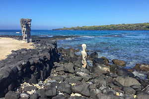 Vigilant gods gazing out to seaThe Kona side of the Big Island has the sunshine, and is pretty much always warm and beautiful. It is also where the best beaches and most activities are.
Beyond that, I am not even going to begin to attempt a description of the western coast of the Big Island, as there are people that have already done that much better. Instead, I highly recommend purchasing the book "Hawaii The Big Island Revealed" before planning your trip. It has an incredibly detailed wealth of information about everything you need to know.
- 1 of 3
- next ›
Kailua-Kona (Big Island) location map in "high definition"
Javascript is required to view this map.
