- Home
- About
- Map
- Trips
- Bringing Boat West
- Migration West
- Solo Motorcycle Ride
- Final Family XC Trip
- Colorado Rockies
- Graduates' XC Trip
- Yosemite & Nevada
- Colorado & Utah
- Best of Utah
- Southern Loop
- Pacific Northwest
- Northern Loop
- Los Angeles to NYC
- East Coast Trips
- Martha's Vineyard
- 1 Week in Quebec
- Southeast Coast
- NH Backpacking
- Martha's Vineyard
- Canadian Maritimes
- Ocracoke Island
- Edisto Island
- First Landing '02
- Hunting Island '02
- Stowe in Winter
- Hunting Island '01
- Lake Placid
- Chesapeake
- Provincetown
- Hunting Island '00
- Acadia in Winter
- Boston Suburbs
- Niagara Falls
- First Landing '99
- Cape Hatteras
- West Coast Trips
- Burning Man
- Utah Off-Roading
- Maui
- Mojave 4WD Course
- Colorado River Rafting
- Bishop & Death Valley
- Kauai
- Yosemite Fall
- Utah Off-Road
- Lost Coast
- Yosemite Valley
- Arizona and New Mexico
- Pescadero & Capitola
- Bishop & Death Valley
- San Diego, Anza Borrego, Joshua Tree
- Carmel
- Death Valley in Fall
- Yosemite in the Fall
- Pacific Northwest
- Utah Off-Roading
- Southern CA Deserts
- Yosemite & Covid
- Lake Powell Covid
- Eastern Sierra & Covid
- Bishop & Death Valley
- Central & SE Oregon
- Mojave Road
- Eastern Sierra
- Trinity Alps
- Tuolumne Meadows
- Lake Powell Boating
- Eastern Sierra
- Yosemite Winter
- Hawaii
- 4WD Eastern Sierra
- 4WD Death Valley +
- Southern CA Deserts
- Christmas in Tahoe
- Yosemite & Pinnacles
- Totality
- Yosemite & Sierra
- Yosemite Christmas
- Yosemite, San Diego
- Yosemite & North CA
- Seattle to Sierra
- Southwest Deserts
- Yosemite & Sierra
- Pacific Northwest
- Yosemite & South CA
- Pacific Northwest
- Northern California
- Southern Alaska
- Vancouver Island
- International Trips
- Index
- Tips
- Books
- Photos/Videos
- Search
- Contact
Mount Rainier National Park, WA
Thursday, July 19, 2001 - 5:30am by Lolo
211 miles and 4.5 hours from our last stop - 1 night stay
Travelogue
Having been to Mount Rainier once before, we knew just how elusive the mountain could be, often hiding in the clouds for days or weeks at a time. On our previous visit in 1990, the mountain had eluded us for our entire stay and we only caught a brief glimpse of it on the morning of our departure. Knowing that, we realized just how lucky we were when during our drive along Route 12 about 30 miles outside of the park, we were greeted with a tremendous view of the mountain in all its splendor. Without hesitation, we turned into a pullout, set up the tripod, and took what we hoped would be great Christmas card shots of us and the RV with the snow-capped Mount Rainier in the background. During the short time that we were pulled over, we could already see clouds moving in, starting to cover the lower portion of the mountain. It would probably be completely hidden by the time we reached the park, but at least we had gotten a chance to see it.
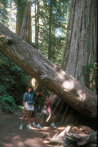
 Family at approach to Mount RainerWe entered the park from the southeast through the Stevens Canyon Entrance and stopped at the Grove of the Patriarchs, a beautiful ancient forest of Douglas fir, hemlock, and Western red cedar trees. From the Visitor Center, we followed the Nature Trail across a bridge over the Ohanapecosh River onto a small island filled with these giant trees. Several times along the way, we almost stepped on some very large slugs, which we later found out were called banana slugs because of their color and size. They just moseyed along at their own slow pace dragging leaves and whatever else was in their path along with them, reminding us a great deal of Andrew, our older son who was always the last one out of the RV at every stop. He didn't quite appreciate the comparison.
 Holding up the redwoodBack in the RV, we continued about 20 miles west into the park and stopped at Paradise, a beautiful subalpine meadow at the very base of Mount Rainier, which unfortunately had already faded into the clouds. Since Paradise is the most popular spot in the park, it is quite crowded, so it took a few trips around the parking lot before we were able to find a parking space. From what I hear, it's lucky that we found one at all. On weekends, especially, this place fills up early.
At the end of the lot sat the historic Paradise Inn, a beautiful rustic stone and log lodge that we had stayed in 11 years ago with Andrew when he was one years old. I just can't get enough of the warmth and coziness of National Park lodges, so I convinced Herb that we should have lunch there. As we crossed the beautiful lobby, with its giant stone fireplace, cedar beams, and high ceilings, I got hit with a tremendous wave of nostalgia as I remembered Andrew crawling around on this floor so many years ago.
Surprisingly, we were seated in the dining room immediately, near a window with a view of the meadow. The atmosphere was wonderful and the food was good as well. Herb had a very interesting and delicious buffalo gulosh dish.
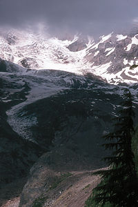
 Mount Rainier SpousalWe walked off lunch on the Nisqually Vista Trail, which begins just west of the Jackson Visitor Center. The trail was an easy 1.25-mile paved loop through wildflowers, past a pond, and up to a tremendous view of the Nisqually Glacier carved into the mountain. Although we were close enough to get a good look at the glacier, the cloud cover that had unfortunately moved in hid the rest of the mountain.
Wanting to make sure we had a place to stay for the night, we headed to Cougar Rock campground where we managed to get a nice site. Right across the road from the campground was the Paradise River and a section of the Wonderland Trail, a 93-mile trail that went around the entire base of Mt. Rainier. Herb and I went for a run on the trail, along the river and past an occasional waterfall, which was pretty enough to distract us from the fact that this trail did nothing but go up.
The river was so peaceful that we got the kids and a picnic supper and spent the evening there. We kept hoping that Mt. Rainier would reappear because our view from here with the river in the foreground would have been incredible. Unfortunately, the mountain didn't cooperate. To get good photos here you either have to be incredibly lucky or be willing to spend at least a week trying. Lucky we caught it on the way in.
Description
Mount Rainier, the highest mountain in the Cascade Range, dominates the landscape of western Washington, often visible for more than 100 miles. Unfortunately, the mountain often hides in the clouds for days or even weeks at a time, making it big news in the Seattle-Tacoma area when it is "out."
 Nisqually GlacierMount Rainier stands 14,411-feet above the surrounding lowlands and 1 ½ miles higher than the surrounding mountains. It is the world's most massive volcano, with its base covering an area of over 100 square miles. Although it has been dormant for more than 150 years, Rainier is still an active volcano with its next predicted big eruption to be in about 500 years.
Mt. Rainier is so high that it makes its own weather. The moist, east winds off the Pacific Ocean are trapped and forced upward by the mountain, resulting in heavy amounts of precipitation on the west side. At lower elevations, the precipitation is in the form of rain, creating the Carbon River Valley rain forest in the northwest corner of the park. At higher elevations, an average of over 50 feet of snow falls a year. As a result of these massive amounts of snow, there are more than 26 glaciers on Mt. Rainier, making it the most glaciated mountain in the lower 48 states.
Every year more than 8,000 climbers attempt to reach its summit, with only about 4,500 reaching the top. Because of its difficulty, mountaineers from around the world use it as a training ground before attempting such peaks as Mt. Everest and K2. However, most of the 2 million annual visitors do not attempt to climb the mountain, but rather spend their time hiking in the beautiful alpine meadow, satisfying themselves with just viewing this incredible mountain.
Because of its close proximity to Seattle and Tacoma, Rainier is a very popular and therefore crowded park, especially during the short July to September summer season where there are often traffic jams and difficulty parking.
 Mount Rainer disappearing in the cloudsMost visitors enter the park from the west at the Nisqually Entrance and stop at Longmire, where there is a museum, visitor center, lodge, campground, and general store. Longmire was the site of the historic 1899 Mineral Springs Resort, the first hotel in the park. The pioneer James Longmire discovered mineral springs here and brought tourists in with the promise of curing their ailments with water treatments. The .7 mile Trail of Shadows Nature trail goes through a wildflower-filled meadow and past what is now a cool mineral spring, the site of the former resort.
About 10 miles east of Longmire is Paradise, the most popular spot in the park, with its beautiful subalpine meadows and endless fields of wildflowers. There are several popular hikes that start from the visitor center here. One of the best is the Nisqually Vista Trail, an easy 1.2-mile hike through the meadow to the base of the Nisqually Glacier. Also at Paradise is the historic 1917 Paradise Inn, a beautiful rustic mountain lodge with spectacular views of the Nisqually Glacier and mountain.
Continuing east from Paradise is the Reflection Lakes, where on a clear, calm day you can see the mountain reflected in the waters. About 20 miles east of Paradise is Ohanepecosh and one of the most popular hikes in the park, the 1.5-mile Grove of Patriarchs Nature Trail. This hike goes through an old-growth forest and over a bridge to a small island in the Ohanepecosh River, dominated by huge ancient red cedar, Douglas-fir, and western hemlock trees.
About 17 miles north of the Grove of Patriarchs is the White River Entrance to the park. From there a 12-mile road winds through thick forests on its way to Sunrise, the highest point in the park accessible by car. From here there are breathtaking views of the meadows, mountains, and glaciers. The ½-mile Emmons Vista Trail goes to an excellent view of Emmons Glacier, Mt. Rainier's largest glacier.
For those that really want to experience hiking at Mount Rainier, there is the 93-mile Wonderland Trail, which completely circles the base of the mountain. Most people allow 2 weeks time to do the whole loop, but portions of it can be done as a day trip.
There are 5 RV campgrounds in the park
- ‹ previous
- 14 of 30
- next ›
Mount Rainier National Park location map
Javascript is required to view this map.
