- Home
- About
- Map
- Trips
- Bringing Boat West
- Migration West
- Solo Motorcycle Ride
- Final Family XC Trip
- Colorado Rockies
- Graduates' XC Trip
- Yosemite & Nevada
- Colorado & Utah
- Best of Utah
- Southern Loop
- Pacific Northwest
- Northern Loop
- Los Angeles to NYC
- East Coast Trips
- Martha's Vineyard
- 1 Week in Quebec
- Southeast Coast
- NH Backpacking
- Martha's Vineyard
- Canadian Maritimes
- Ocracoke Island
- Edisto Island
- First Landing '02
- Hunting Island '02
- Stowe in Winter
- Hunting Island '01
- Lake Placid
- Chesapeake
- Provincetown
- Hunting Island '00
- Acadia in Winter
- Boston Suburbs
- Niagara Falls
- First Landing '99
- Cape Hatteras
- West Coast Trips
- Burning Man
- Utah Off-Roading
- Maui
- Mojave 4WD Course
- Colorado River Rafting
- Bishop & Death Valley
- Kauai
- Yosemite Fall
- Utah Off-Road
- Lost Coast
- Yosemite Valley
- Arizona and New Mexico
- Pescadero & Capitola
- Bishop & Death Valley
- San Diego, Anza Borrego, Joshua Tree
- Carmel
- Death Valley in Fall
- Yosemite in the Fall
- Pacific Northwest
- Utah Off-Roading
- Southern CA Deserts
- Yosemite & Covid
- Lake Powell Covid
- Eastern Sierra & Covid
- Bishop & Death Valley
- Central & SE Oregon
- Mojave Road
- Eastern Sierra
- Trinity Alps
- Tuolumne Meadows
- Lake Powell Boating
- Eastern Sierra
- Yosemite Winter
- Hawaii
- 4WD Eastern Sierra
- 4WD Death Valley +
- Southern CA Deserts
- Christmas in Tahoe
- Yosemite & Pinnacles
- Totality
- Yosemite & Sierra
- Yosemite Christmas
- Yosemite, San Diego
- Yosemite & North CA
- Seattle to Sierra
- Southwest Deserts
- Yosemite & Sierra
- Pacific Northwest
- Yosemite & South CA
- Pacific Northwest
- Northern California
- Southern Alaska
- Vancouver Island
- International Trips
- Index
- Tips
- Books
- Photos/Videos
- Search
- Contact
Mount Rainier National Park, WA
Friday, July 5, 2013 - 11:00am by Lolo
100 miles and 2.5 hours from our last stop - 2 night stay
Travelogue
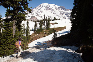 Lolo approaching the Skyline TrailMount Rainier had pretty much dominated the horizon during our entire tour of Seattle. Practically everywhere we went, there it was rising in all its majesty above the city. We were very fortunate, because more often than not, the mountain is hidden in the clouds, and you are not even aware that it is there.
Although we had been to Mt. Rainier in the past, it was definitely worth a revisit, especially since the skies had been so clear the last few days. I called and booked two nights at the Mounthaven RV Resort, located just ½ mile from the Nisqually entrance to the park.
We were very pleasantly surprised when we arrived at the campground. It was small – only 16 RV sites – and nestled in a grove of cedars. Plus it was a very convenient base from which to explore the park.
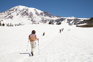 Lolo on Skyline TrailDespite the fact that our clear skies had given way to a thick cloud cover obscuring the mountain, we drove to the Longmire Museum and Ranger Station, about 6 ½ miles into the park, to get some hiking options for the next day. I already had the answer in mind, as I had read that if you only have time to do one hike in Mt. Rainier, it should be the Skyline Trail.
We spoke to some rangers at Longmire, who were very helpful, but couldn’t tell us with any surety what we wanted to hear – namely, that the mountain would be out in the clear tomorrow. I think that no one really knows what it is going to do at any particular point in time, and even if it does come into view, it can quickly disappear. Herb was not very pleased when she suggested some hikes with lovely views of wildflowers. Now, we like wildflowers as much as the next guy, but that was not what we came here for. We wanted to see and be out on the mountain.
 Herb Hikes tooWhen we expressed our strong preference for a mountain hike, she informed us that the hike we had picked out ourselves, the Skyline Trail from Paradise, had too much snow on it to complete the entire loop. Sensing our disappointment and determination, she suggested that perhaps we could hike the Skyline Trail to where the snow got too high, and then make it into a loop by taking the Golden Gate Trail down. This definitely appealed to us more than the wildflower meander. Now we just had to hope for clear skies.
On the way back, we stopped to take the short walk down to Narada Falls, but the day was too gray to really get any good photos.
The next morning we were absolutely thrilled to wake up to clear blue skies. Although our campsite was too nestled in the forest to have any views, I just knew that Mt. Rainier was out there strutting her stuff.
 Lolo contemplating the dreaded Snow TraverseWe quickly got our gear together and drove to the Paradise Visitor Center to start our hike. Paradise is aptly named , because it is truly the most beautiful part of the park. This is where the historic, and very cozy, I might add, Paradise Inn is located and it is also the starting point for mountaineers climbing to the summit.
The trailhead for the Skyline Trail is located just to the left of the Ranger Station in the large parking lot at Paradise. While walking to the trailhead, I stopped a ranger in the parking lot and asked her if our plan to hike the Skyline Trail to the Golden Gate Trail was a good one. She confirmed that it was in fact an excellent choice and even complimented my Asolo hiking boots as being perfect for the conditions.
The trail started out on the stone steps behind the Henry M. Jackson Visitor Center and climbed briefly up to a series of trail junctions. There are a lot of trails starting from Paradise, but they are very well marked and heavily traveled. At the junction, we bore right, following the signs to Panorama Point on the Skyline Trail.
 Lolo Conquering the Dreaded Snow TraverseWe were definitely not the only ones with this trail in mind. After all, it was a perfect day and the entire mountain was in view. In addition to being a day hiking trail, this trail was also the starting point for ascents to the summits, so there were dozens of climbers laden down with heavy packs and equipment making their way up to base camp before dark. From there, the next morning they would rise by 3:00 am to do the really tough part up to the top. While most of them looked very fit and prepared, I was a bit concerned about the potential success of a few of them.
One gentleman in particular was very slowly and deliberately walking, one foot forward, pause, then the other foot foward, pause -- kind of like you see on Mt. Everest ascent movies when climbers are nearing the top. The problem was that he was still within sight of the parking lot. His brand new gear – so new that I actually looked to see if the price tags were still on – was swaying from side to side as he labored up the mountain. Also, unlike other large parties of climbers accompanied by a guide, he was all alone. I certainly hoped he knew what he was doing.
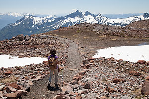 Lolo on the Golden Gate TrailA bit further on, we passed another situation in which a rather frustrated guide, whose job it obviously was to hang back with the slowest in the party, was expressing concern to one of the climbers in his group that if he was feeling that bad already, there was an awfully long way to go, and he should perhaps reconsider his continuing on.
This mountain was serious business, and I can imagine the guide’s dilemma of having to suggest to someone that probably had paid a lot of money and had done a lot of training to get to this point, that maybe they should turn back. Going on could not only jeopardize himself, but perhaps the safety of the entire group.
In the meantime, we were having the hike of our lives. The sky was so blue, and being so up close and personal with Mt. Rainier and the Nisqually Glacier was truly an awesome experience. As we got higher and higher up the trail, there was more and more snow on the side of the trail and less and less meadow. At approximately 2 miles we reached aptly named Panorama Point, and when we turned our backs on Mt. Rainer, we were treated to a spectacular view of Mt. Adams, Mt. Hood, and Mt. Saint Helens in the distance.
 Triumphant Lolo "cheating death" againThe mountains of the Pacific Northwest are so different than those of the Rockies in that since they are volcanoes, they rise up as a single mountain rather than as part of a range. This makes them so much more dramatic, and I guess a little more frightening, if you think about why they are formed the way they are.
The Skyline Trail continued climbing for a bit above Panorama Point before dropping down to a field of snow covered rocks. At first I got a little nervous – I had had a bad experience with a snowy traverse in Rocky Mountain National Park the previous year. I suggested to Herb that maybe we should think about turning around and retracing our steps down the Skyline Trail, but he was having none of it, so we continued on. Crossing the snow really wasn’t that bad, especially with the help of trekking poles. After approximately another mile, we came to the junction for the Golden Gate Trail, which was the route the ranger suggested for the descent to Paradise.
The way down was equally, if not even more, spectacular than the way up, but quite different. Rather than Mt. Rainier dominating our view, we now were looking out over a vast expanse that extended all the way to Oregon.
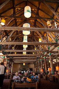 Paradise Inn Great HallAbout a third of the way down, we ran into a party of three young men on their way up the Golden Gate Trail, who warned us that they had just had to climb some very steep snowy areas. I didn’t particularly like hearing this, and once again questioned Herb as to whether we should turn back. At this point, turning back and retracing our steps would make for a very long hike. Herb calmed me down and convinced me to go on.
Once again, it really was not a big deal. I don’t mind going down steep snowy slopes when there is no dropoff or boulders to hit at the bottom. This was more like a very steep sleigh riding hill. I was so glad Herb talked me into continuing.
When we arrived back down in Paradise, we just had to go into the historic Paradise Inn. I absolutely love the warmth and coziness of National Park lodges, and this one was one of my favorites. We had been here several times in the past – our first was 23 years ago when we stayed at the Inn with Andrew when he was just one year old, and then again in 2001 when we came back with both Andrew and Tommy and had lunch in the beautiful dining room. This time all I was getting was coffee, but still it was great to just sit in front of one of the giant stone fireplaces in the great hall, contentedly sipping my mocha.
What a perfect day!
 Mount Rainier from Wonderland Trail near Reflection LakesBut it wasn’t over yet. That evening, after dinner in the motorhome, we drove back into the park once again to photograph the mountain in the evening light. This time, we drove all the way past Paradise to Reflection Lakes, where if conditions are just right, you can see the mirror image of the mountain in the lake. This is the iconic shot of Mt. Rainier. Unfortunately, by the time we got there, the clouds had already moved in obstructing the mountain. Oh well. The mountain owed us nothing. We had gotten to play with it all day.
We took a brief stroll along the lakeshore on a portion of the Wonderland Trail, which encircles the entire mountain. This trail, on which we hiked about ¼ mile, is 93 miles long, and is supposed to be a spectacular 8-day backpacking trip.
I am sure that someday soon, especially since Tommy is now living only 2 hours away in Seattle, we will be back to Mt. Rainier. But next time I will be whining about more than a little snowfield to cross, because Herb has officially added backpacking the Wonderland Trail and climbing to the summit of Mt. Rainier to our bucket list. I am not sure if you are allowed to add things to a bucket list that you have already done in your life, but I don’t care. Staying at the Paradise Inn again is now officially on there as well.
Description
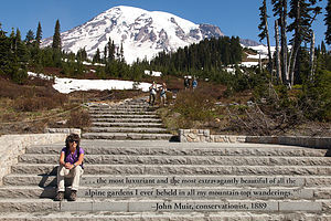 Lolo channeling John Muir for the hike up Mount RainierMount Rainier, the highest mountain in the Cascade Range, dominates the landscape of western Washington, often visible for more than 100 miles. Unfortunately, the mountain often hides in the clouds for days or even weeks at a time, making it big news in the Seattle-Tacoma area when it is "out."
Nisqually GlacierNisqually GlacierMount Rainier stands 14,411-feet above the surrounding lowlands and 1 ½ miles higher than the surrounding mountains. It is the world's most massive volcano, with its base covering an area of over 100 square miles. Although it has been dormant for more than 150 years, Rainier is still an active volcano with its next predicted big eruption to be in about 500 years.
Mt. Rainier is so high that it makes its own weather. The moist, east winds off the Pacific Ocean are trapped and forced upward by the mountain, resulting in heavy amounts of precipitation on the west side. At lower elevations, the precipitation is in the form of rain, creating the Carbon River Valley rain forest in the northwest corner of the park. At higher elevations, an average of over 50 feet of snow falls a year. As a result of these massive amounts of snow, there are more than 26 glaciers on Mt. Rainier, making it the most glaciated mountain in the lower 48 states.
 Camping at Mounthaven RV ResortEvery year more than 8,000 climbers attempt to reach its summit, with only about 4,500 reaching the top. Because of its difficulty, mountaineers from around the world use it as a training ground before attempting such peaks as Mt. Everest and K2. However, most of the 2 million annual visitors do not attempt to climb the mountain, but rather spend their time hiking in the beautiful alpine meadow, satisfying themselves with just viewing this incredible mountain.
Because of its close proximity to Seattle and Tacoma, Rainier is a very popular and therefore crowded park, especially during the short July to September summer season where there are often traffic jams and difficulty parking.
Mount Rainer disappearing in the cloudsMount Rainer disappearing in the cloudsMost visitors enter the park from the west at the Nisqually Entrance and stop at Longmire, where there is a museum, visitor center, lodge, campground, and general store. Longmire was the site of the historic 1899 Mineral Springs Resort, the first hotel in the park. The pioneer James Longmire discovered mineral springs here and brought tourists in with the promise of curing their ailments with water treatments. The .7 mile Trail of Shadows Nature trail goes through a wildflower-filled meadow and past what is now a cool mineral spring, the site of the former resort.
About 10 miles east of Longmire is Paradise, the most popular spot in the park, with its beautiful subalpine meadows and endless fields of wildflowers. There are several popular hikes that start from the visitor center here. One of the best is the Nisqually Vista Trail, an easy 1.2-mile hike through the meadow to the base of the Nisqually Glacier. Also at Paradise is the historic 1917 Paradise Inn, a beautiful rustic mountain lodge with spectacular views of the Nisqually Glacier and mountain.
Continuing east from Paradise is the Reflection Lakes, where on a clear, calm day you can see the mountain reflected in the waters. About 20 miles east of Paradise is Ohanepecosh and one of the most popular hikes in the park, the 1.5-mile Grove of Patriarchs Nature Trail. This hike goes through an old-growth forest and over a bridge to a small island in the Ohanepecosh River, dominated by huge ancient red cedar, Douglas-fir, and western hemlock trees.
About 17 miles north of the Grove of Patriarchs is the White River Entrance to the park. From there a 12-mile road winds through thick forests on its way to Sunrise, the highest point in the park accessible by car. From here there are breathtaking views of the meadows, mountains, and glaciers. The ½-mile Emmons Vista Trail goes to an excellent view of Emmons Glacier, Mt. Rainier's largest glacier.
For those that really want to experience hiking at Mount Rainier, there is the 93-mile Wonderland Trail, which completely circles the base of the mountain. Most people allow 2 weeks time to do the whole loop, but portions of it can be done as a day trip.
There are 5 RV campgrounds in the park
- ‹ previous
- 9 of 15
- next ›
Mount Rainier National Park location map in "high definition"
Javascript is required to view this map.

Lolo and Herb,
I just wanted to say a big thanks for your thorough site and all you have put into it! Your travels have been a huge inspiration to us! Your adventures and detailed write-ups (along with the NPS.gov site) have been my main source for planning our cross-country trips to see our great National Parks over the last 3 years (and I do obsessivley plan every detail, too!). I have also documented our trips (not as spectacularly as you) for family and ourselves (http://thedavidzoo.wordpress.com).
We began seriously in the summer of 2012 with or first 4-week trip with a pickup truck and 24 ft travel trailer. Our two boys were 12 and 9 years old at the time. In 2013 we took another spectacular month-long trip. This year we had a full 60 days to circle the country clockwise! Next year, hopefully Alaskan and Canadian National Parks!
We have spied a few Lazy Daze RVs at various stops and were always disappointed when someone other than Lolo and Herb emerged! I would have loved to thank you in person.
Safe travels to you and yours!
Hi Esther,
Thank you for your comment, and kind words about our website. Your site is very nicely done and the photo albums are great. I need to spend some more time on your site to see what we may have missed and I'm glad we may have inspired you for your own travels.
A 60 day trip is quite an accomplishment.. We usually approach "trip fatigue" around 3 1/2 weeks,, but I guess it's all in the pacing.
Alaska and Canada are truly extraordinary. We didn't have the time to take our own rig up to Alaska but the road up should be quite an adventure.
Seems like you have got it all figured out at this point, and I wish you continued safe travels.
Best, Herb and Lolo