- Home
- About
- Map
- Trips
- Bringing Boat West
- Migration West
- Solo Motorcycle Ride
- Final Family XC Trip
- Colorado Rockies
- Graduates' XC Trip
- Yosemite & Nevada
- Colorado & Utah
- Best of Utah
- Southern Loop
- Pacific Northwest
- Northern Loop
- Los Angeles to NYC
- East Coast Trips
- Martha's Vineyard
- 1 Week in Quebec
- Southeast Coast
- NH Backpacking
- Martha's Vineyard
- Canadian Maritimes
- Ocracoke Island
- Edisto Island
- First Landing '02
- Hunting Island '02
- Stowe in Winter
- Hunting Island '01
- Lake Placid
- Chesapeake
- Provincetown
- Hunting Island '00
- Acadia in Winter
- Boston Suburbs
- Niagara Falls
- First Landing '99
- Cape Hatteras
- West Coast Trips
- Burning Man
- Utah Off-Roading
- Maui
- Mojave 4WD Course
- Colorado River Rafting
- Bishop & Death Valley
- Kauai
- Yosemite Fall
- Utah Off-Road
- Lost Coast
- Yosemite Valley
- Arizona and New Mexico
- Pescadero & Capitola
- Bishop & Death Valley
- San Diego, Anza Borrego, Joshua Tree
- Carmel
- Death Valley in Fall
- Yosemite in the Fall
- Pacific Northwest
- Utah Off-Roading
- Southern CA Deserts
- Yosemite & Covid
- Lake Powell Covid
- Eastern Sierra & Covid
- Bishop & Death Valley
- Central & SE Oregon
- Mojave Road
- Eastern Sierra
- Trinity Alps
- Tuolumne Meadows
- Lake Powell Boating
- Eastern Sierra
- Yosemite Winter
- Hawaii
- 4WD Eastern Sierra
- 4WD Death Valley +
- Southern CA Deserts
- Christmas in Tahoe
- Yosemite & Pinnacles
- Totality
- Yosemite & Sierra
- Yosemite Christmas
- Yosemite, San Diego
- Yosemite & North CA
- Seattle to Sierra
- Southwest Deserts
- Yosemite & Sierra
- Pacific Northwest
- Yosemite & South CA
- Pacific Northwest
- Northern California
- Southern Alaska
- Vancouver Island
- International Trips
- Index
- Tips
- Books
- Photos/Videos
- Search
- Contact
Oregon Dunes National Recreation Area, OR
Thursday, August 12, 2021 - 1:30pm by Lolo
40 miles and 0.75 hours from our last stop - 1 night stay
Travelogue
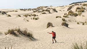
 John Dellenback Trail along the Umpqua DunesOf course before leaving Bandon, I had planned out our next destination and where we could camp. Not only did I find and reserve one campsite, but I reserved two because I wasn’t sure yet which one would be better to accomplish what we wanted to do, which was hike the John Dellenback Dunes Trail in the Oregon Dunes National Recreation Area.
National Park camping is quite inexpensive, and even more so with a Seniors Lifetime Pass, which cuts the price in half. So, the downside of doing this was the loss of $10 on the campsite we did not use.
 From dune to forest to oceanOne campground was the Eel Creek USFS Campground where the John Dellenback trail started. The second one was Umpqua Sand Camping, an OHV area on the beach, which would assuredly be noisy with dune buggies racing up and down the beach all day and night. Also, we weren’t sure if we would be able to find the other end of the John Dellenback Dunes Trail from there. After all, the Oregon Dunes NRA is the largest expanse of coastal sand dunes in North America, stretching 40 miles along the Oregon Coast from Florence to Coos Bay.
So, after first stopping at Eel Creek, we decided to stay there, as it was quiet and the trailhead for our planned hike was just a few campsites away.
 The ocean part of the John Dellenback TrailThe hike was listed as a 3 (out of 5) in difficulty because of having to plod along deep, soft sand, but a 9 (out of 10) in scenic beauty. The campground host we spoke to felt like it was more of a 4 in difficulty.
Ok, so this hike could double as a workout. We set off from the trailhead in the campground and immediately began climbing a steep, yet short, deep sandy section through a conifer-forest before coming out to the dunes.
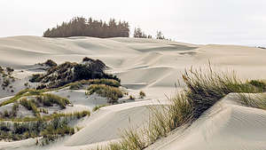
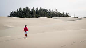
Theoretically, there were poles with blue stripes on top used as trail markers, but so far we couldn’t see one. Herb had a Gaia trail downloaded on his watch, so we followed that towards a large grouping of conifer trees atop a dune. I’ve been to many deserts on our travels, but never saw one with so many trees.
 Umpqua Dunes along the John Dellenback TrailThese tree islands are a prominent topographic feature of the Oregon Dunes and make for a very different dune visual experience. I don’t quite understand the explanation for these tree islands, but it has something to do with the fact that these are oblique dunes with long gradual slopes on the west (ocean) side and much steeper slopes on the east side. Over many years wind stripped away the sand on the east (inland) side down to the permanently wet sand where water-loving vegetation can thrive. These areas are called deflation plains.As the dunes move eastward, the plants of the deflation plain also spread eastward.
Trudging through the sand was nowhere nearly as difficult as the hiking book or campground host led us to believe. Plus, we finally were able to find and follow the posts with the blue stripe on top. Good thing because we eventually entered a pretty thick forest and I don’t know how we would have found the opening without the post.
 Umpqua DunesThis part of the hike was really cool as it led us on an easy dirt surface with the occasional boardwalk to get us over the wetter areas. There was even Spanish moss hanging from some of the trees. It was hard to believe we had just left sand dunes.
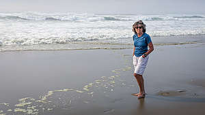
Eventually we popped out on a beautiful beach with crashing surf. There was no sign of OHV vehicles, or anyone for that matter, so I think we made a good choice staying at Eel Creek because we never would have been able to get to this trail from the OHV camping area.
The way back was much easier to navigate now that we knew the way. All in all it was a 6-mile hike, and much less difficult than we anticipated.
- ‹ previous
- 3 of 8
- next ›
Oregon Dunes National Recreation Area location map in "high definition"
Javascript is required to view this map.
