- Home
- About
- Map
- Trips
- Bringing Boat West
- Migration West
- Solo Motorcycle Ride
- Final Family XC Trip
- Colorado Rockies
- Graduates' XC Trip
- Yosemite & Nevada
- Colorado & Utah
- Best of Utah
- Southern Loop
- Pacific Northwest
- Northern Loop
- Los Angeles to NYC
- East Coast Trips
- Martha's Vineyard
- 1 Week in Quebec
- Southeast Coast
- NH Backpacking
- Martha's Vineyard
- Canadian Maritimes
- Ocracoke Island
- Edisto Island
- First Landing '02
- Hunting Island '02
- Stowe in Winter
- Hunting Island '01
- Lake Placid
- Chesapeake
- Provincetown
- Hunting Island '00
- Acadia in Winter
- Boston Suburbs
- Niagara Falls
- First Landing '99
- Cape Hatteras
- West Coast Trips
- Burning Man
- Utah Off-Roading
- Maui
- Mojave 4WD Course
- Colorado River Rafting
- Bishop & Death Valley
- Kauai
- Yosemite Fall
- Utah Off-Road
- Lost Coast
- Yosemite Valley
- Arizona and New Mexico
- Pescadero & Capitola
- Bishop & Death Valley
- San Diego, Anza Borrego, Joshua Tree
- Carmel
- Death Valley in Fall
- Yosemite in the Fall
- Pacific Northwest
- Utah Off-Roading
- Southern CA Deserts
- Yosemite & Covid
- Lake Powell Covid
- Eastern Sierra & Covid
- Bishop & Death Valley
- Central & SE Oregon
- Mojave Road
- Eastern Sierra
- Trinity Alps
- Tuolumne Meadows
- Lake Powell Boating
- Eastern Sierra
- Yosemite Winter
- Hawaii
- 4WD Eastern Sierra
- 4WD Death Valley +
- Southern CA Deserts
- Christmas in Tahoe
- Yosemite & Pinnacles
- Totality
- Yosemite & Sierra
- Yosemite Christmas
- Yosemite, San Diego
- Yosemite & North CA
- Seattle to Sierra
- Southwest Deserts
- Yosemite & Sierra
- Pacific Northwest
- Yosemite & South CA
- Pacific Northwest
- Northern California
- Southern Alaska
- Vancouver Island
- International Trips
- Index
- Tips
- Books
- Photos/Videos
- Search
- Contact
Parque Nacional de Los Picos de Europa, Spain
Tuesday, June 4, 2019 - 9:45pm by Lolo
25 miles and 0.75 hours from our last stop - 3 night stay
Travelogue
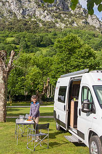 Our campground in the Picos de EuropaIt had been a long driving day - hard to believe we were in Salamanca just this morning. Then there was the side trip up the winding road to the Basilica de Covadonga, which was awesome by the way.
Herb was pretty beat from driving. That’s why I was pretty surprised when he agreed to my suggestion of checking out the trailhead and parking situation for the Ruta del Cares hike we were planning to do tomorrow, before we checked into our campground.
It didn’t look like a big deal on Google Maps, but it turned out to be another very winding road, which ended in very rough stones with no place to turn around - oops!. After an 8-point turn and some less than kind words, Herb got the van turned around and pointed to the campground, with the very strong suggestion of no more stops.
Well, at least we learned something. We would take a taxi to the trailhead and back.
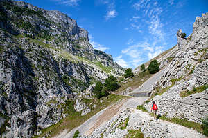 Lolo heading off on the Rute del Cares TrailFinally, around dinner time, we pulled into Camping Naranjo de Bulnes. As promised when I called them earlier, there were plenty of sites to choose from, as it was still early in the season.
After spending so much time in cities, it was nice to once again be camping surrounded by natural beauty, which really is more our thing. The lovely mountain views and a nearby river quickly improved morale - a well-deserved beer didn’t hurt either.
The facilities were very nice and there was even a little WiFi to be had near the reception office.
All this was a plus, as the real reason we had chosen this campground was its proximity to the Ruta del Cares Trail (just 8 km away), one of the three epic hikes in Spain that I had selected during my research back home.
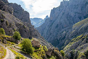 Along the Rute del Cares TrailHowever, the weather was not great, and the forecast for tomorrow was no better - pretty much rain and wind all day. Argghh! This would be the second time that our planned hike would be thwarted by weather. With the wind situation closing El Caminito del Rey last week, we just waited around another day and got it in. Hopefully, the same would happen here, and we would get a good day to hike the day after tomorrow.
Like the El Camiito del Rey, the Ruta del Cares is another hike along a gorge with precipitous drop-offs, but unlike El Caminito del Rey, this one had no handrails. I definitely wanted good conditions to do it in -- like no big winds pushing me off..
Meanwhile we had a so-so weather day to kill. Fortunately, I had a plan. The little stone village of Santillana del Mar and the nearby Altamira caves had been on my list as a place to stop when we continued east to Bilbao. Although it was an hour away, we figured it was better than sitting in the van in the rain.
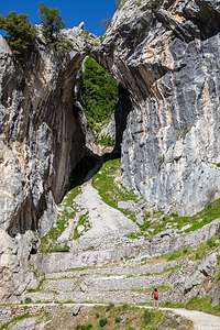 Along the Ruta del Cares trailIt turned out to be a really worthwhile destination, so much so that rather than describe that excursion here, I thought I would give it the dignity of its own stop - see next page for a description of our excursion to Santillana del Mar.
By the time we got back to the campground, the skies had cleared, and it was a very nice evening. Perhaps we would be able to hike the Ruta del Cares tomorrow.
Sure enough, the next morning the sun was shining and the winds were light. We packed up for the day and headed over to the campground office, where the girl that checked us in promised to call us a taxi to take us to the trailhead. After our trial run at driving to the trailhead the other day and having to do a 10-point turn on sharp rocks to get out of there, Herb had definitely decided that no matter how expensive the cab was, it would be worth it. It actually wasn’t bad - just 8 € each way.
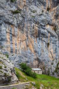 Along the Ruta del Cares trailAs we drove through the quaint little town of Asturia, our taxi driver kept beeping and sticking his arm out the window. At first I thought he was expressing his annoyance with other drivers, but then I realized that they were all beeping back and waving. They just all knew each other and were saying good morning.
We said our goodbyes at the trailhead with the promise of calling him to retrieve us when we were done in about 6 or 7 hours.
I was pretty excited, as the Ruta del Cares is considered to be one of the most breathtaking trekking trails in all of Europe. We had already virtually experienced the trail by watching several YouTube videos, but nothing can compare to the real thing.
The 7.5-mile trail traverses the Picos de Europa National Parque, connecting the town of Poncebos (where we were) in the north to Cain in the South. Since it’s a 65 mile drive between the towns, most people do it as an out-and-back, which means it is really a 15-mile hike.
The first mile or so is a steady climb - the only along the otherwise relatively flat route. Once on top, the most beautiful part of the route begins and the stunning scenery just keeps on going all the way to Cain.
The trail, which was hacked out of the cliff face, runs alongside the Cares Gorge (appropriately nicknamed the Divine Gorge) with stunning limestone mountain peaks rising all around us.
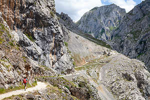 Along the Ruta del Cares trailWe had to be careful not to get too distracted with the scenery, because the footpath is quite narrow (less than 1 ½ meters) in places and precariously close to the edge, with a 1,000 meter drop straight down to the river. It was much scarier than the Caminito del Rey hike we had done earlier in the trip, as there were no handrails to prevent us from falling over the edge.
The scenery was so distracting that before we knew it we were at the other end. The final stretch into the tiny village of Cain led us through a series of tunnels chiseled out of the limestone and across a footbridge over the Cares River. The village was very quaint, with just a few restaurants and a cafe. Unfortunately the cafe was closed, destroying my dreams of having an American before hiking back.
On the way back the wind really started to pick up as it funneled through the gorge. This would make the narrow, precarious parts of the trail even more exciting. I found myself leaning in towards the wall and staying as far away from the edge as possible.
 I'm not sure which one of us is more curiousWhen we were almost back to Poncebos, we encountered a few of the trail’s famous, friendly mountain goats, who were a lot less concerned about the wind than I was. No leaning into the cliff for them.
They certainly were not shy. They were so curious and anxious to interact that Herb spent a good half hour photographing them. There are more photos of goats than there are of me on this trip.
The hike had very much lived up to my anticipation of it. It was absolutely stunning, every inch of the way.
Back at the trailhead, we called our taxi driver who delivered us back to our campground, beeping and waving at everyone along the way.
Description
 Along the Ruta del Cares trailPicos de Europa National Park contains some of Europe’s most spectacular scenery and some of Spain’s finest walking country. Its stunning limestone mountain peaks are the highest in Spain, and lie just 15 miles inland from the Atlantic Ocean.
One of the most famous hikes in all of Spain is the Ruta del Cares in the Picos de Europa. The 7.5-mile trail runs alongside the Cares Gorge (nicknamed the Divine Gorge) along an amazing footpath hacked out of the cliff face, at the edge of the 1,000 meter deep gorge. At times the trail is rather narrow and a bit precariously close to the edge. It is considered to be one of the most breathtaking trekking trails in all of Europe.
The trail goes from the town of Poncebos in the north to Cain in the South.
The nearest camping to the start of the trail is Camping Naranjo de Bulnes in the town of Asturias (8 km from trailhead).
- ‹ previous
- 12 of 20
- next ›
Parque Nacional de Los Picos de Europa location map in "high definition"
Javascript is required to view this map.
