Rocky Mountain National Park, CO
The boys left bright and early to get back to Boulder, leaving Herb and I to venture out on our own for the next few days. After mulling over several options, we decided to drive the scenic Trail Ridge Road through the park and camp at Timber Creek on the western side of the park. Along the way, we would try to find a hike for the following day that would be equally spectacular to the Chasm Lake hike, without the cheating death part.
This was not our first time driving the Trail Ridge Road. We had driven it with the kids ten years ago, and it was about time we did it again. Along its very scenic 50 miles from Estes Park to Grand Lake, it winds its way 12,183 feet above sea level into tundra similar to the arctic regions of Alaska and Siberia. Along the way there are spectacular views of snow-covered peaks, alpine meadows full of wildflowers, dense forests, and lots of wildlife.
As lovely as the drive was, it still couldn’t compare to the experience of actually getting out of the car and hiking into the wilderness. We were on a quest to find another hike as inspiring as the one we did the day before.

There was quite a bit of traffic on the road, so we thought there was no way we would find parking for the RV at the Alpine Visitor Center. However, to our delight, a park service employee waved us in, and moved an orange cone for us to park. This was new—saving spaces for RVs. I liked it. As soon as we got out of the RV, and before I had a chance to do anything embarrassing, the man in a Lazy Daze RV next to us said, “Hey, aren’t you the people that write that blog about cross country traveling.” Wow! Our second fan in one trip. I was beginning to feel like a celebrity. Actually, he recognized our Lazy Daze motorhome, which is pretty unique looking, I guess.
Once inside the visitor center, we asked a ranger for a recommendation for a hike that would be as spectacular as the one to Chasm Lake. He told us that his absolute favorite hike in the park was the hike to the top of Mt. Ida. He also mentioned that he heard that someone had slid down and gotten hurt at Chasm Lake the day before. We told him that not only did we know that, but we had actually been the first ones to get to him. I guess the good news was that the fall seemed to be rare enough to have really made news in the park.

We were happy now. We had our planned hike for tomorrow and it seemed like a really good one. Now, it was a matter of getting one of the first-come-first-served campsites at Timber Creek towards the end of Trail Ridge road. The next morning we rose at 5:30, or at least one of us did, to drive the 10 miles back to the trailhead to secure a parking space. Herb was kind enough to let me continue snoozing in the back of the RV. He was less kind when he filmed me doing so.
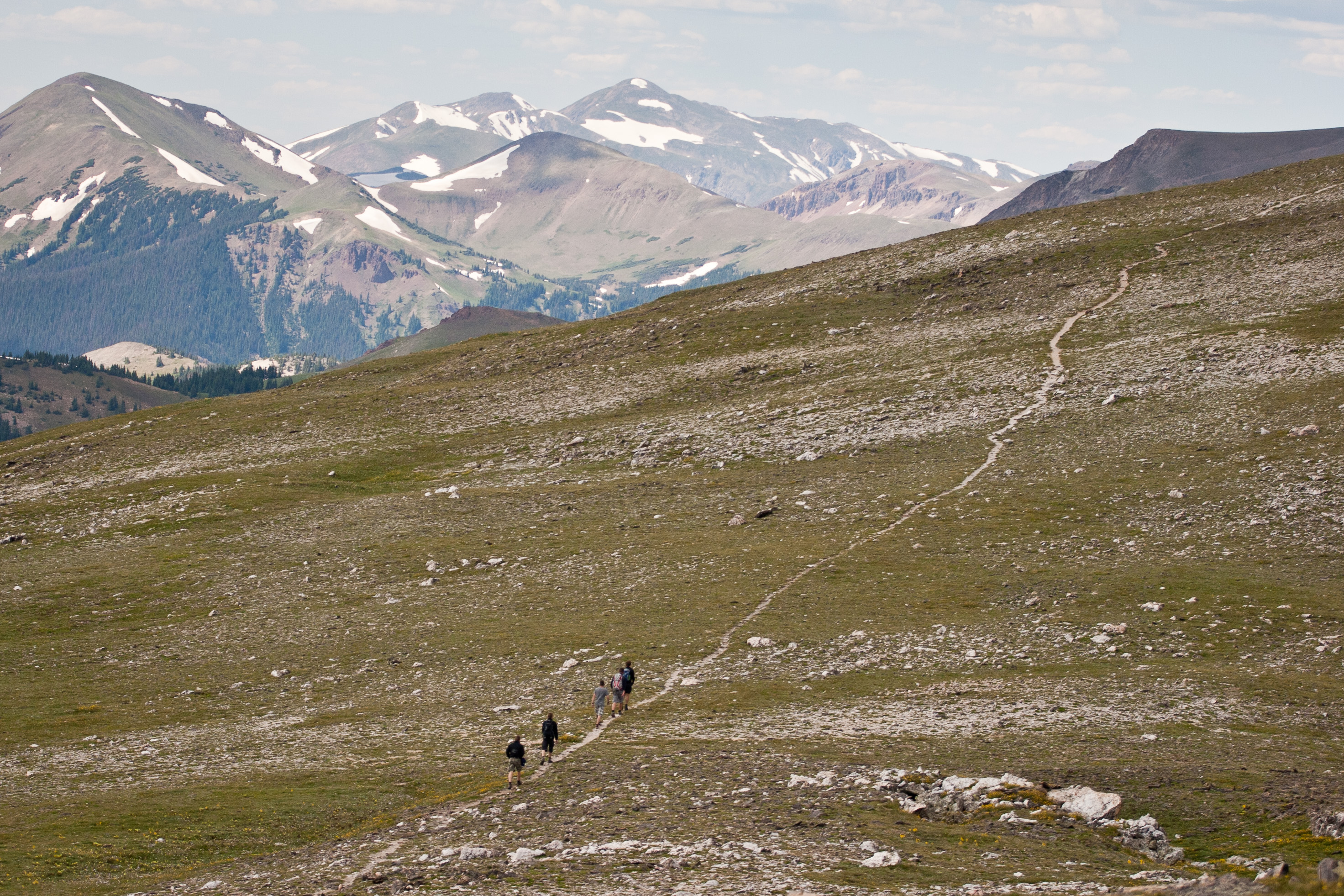
We had a leisurely breakfast in the RV, while watching the elk graze outside our back window. People were already beginning to gather at the trailhead, but mostly to just look at the wildlife before moving on. After packing our backpacks with camera and video equipment, lunch, plenty of drinks, and rain jackets in case the afternoon thunderstorms came in, we set off on the trail, which began at the south end of Poudre Lake and climbed through forest for what should have been 1.5 miles. However, I was in the lead and missed the junction for the Mt. Ida trail and wound up adding an extra 2 miles (luckily flat ones) to an already long hike. We had started to think we were off route when we ran into two elderly, but very in shape women, who told us we were way off. They pointed us back in the right direction and Herb took over the lead. We were soon above the treeline with expansive views of meadows filled with wildflowers and big-horned sheep and snow-capped mountains in the distance. Since the trail was laid out by wildlife, it did not switchback as it climbed. Instead it traced the south side of the Continental Divide. What was really cool was that we could see the trail for miles ahead, so we knew exactly what was ahead of us.

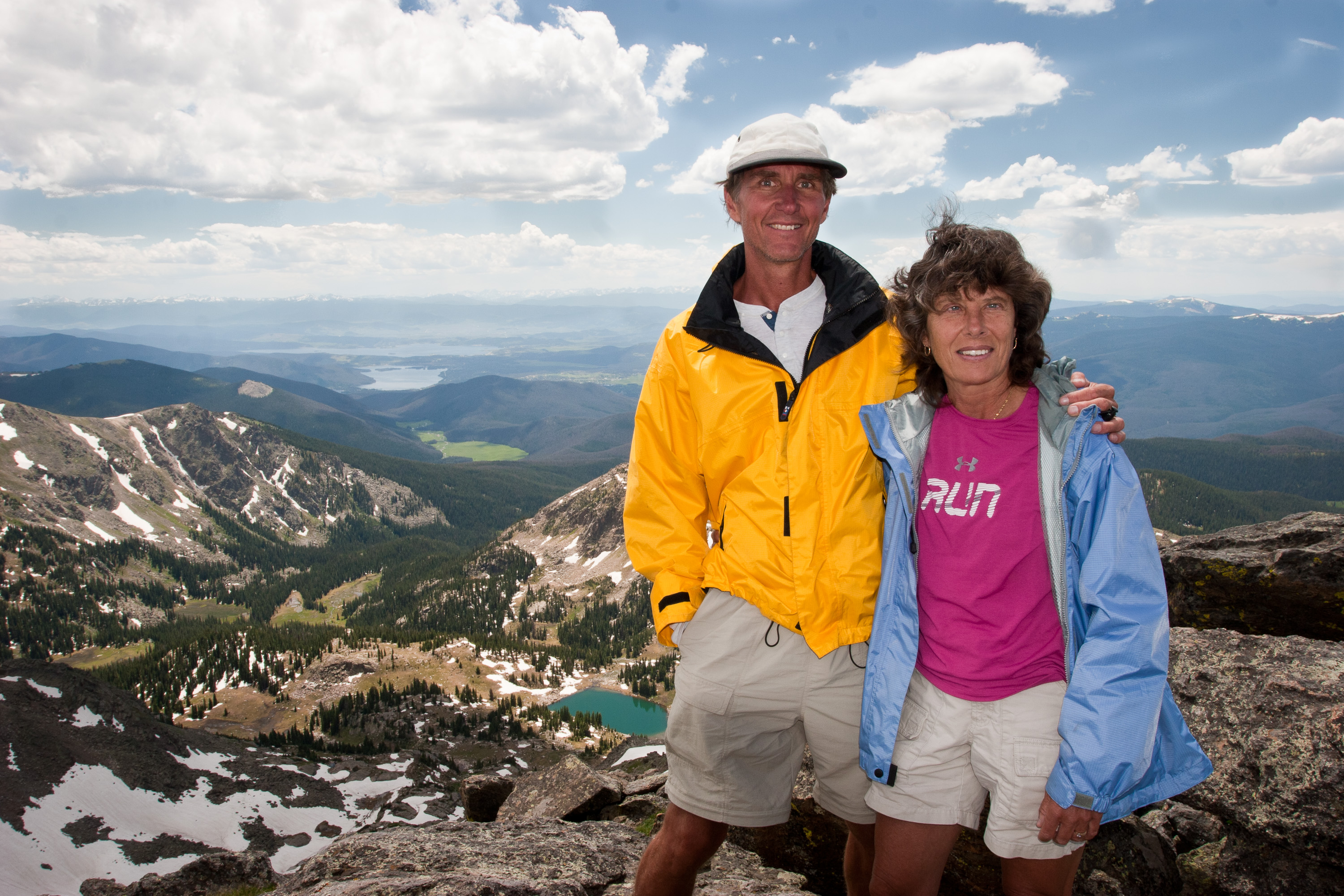
At about 3 miles from the trail junction (and what should have been 4.5 miles into our hike, but was 6.5 instead), the trail gave out and the rock scrambling began. The wind had picked up a bit and the clouds were beginning to look a bit ominous, but we didn’t want to turn back. It’s amazing how much weather you can see in these open expanses. We would just have to keep a careful watch to make sure the bad stuff wasn’t moving our way. The rock scrambling did seem to go on and on through at least a couple of false summits before we arrived at the top of Mount Ida on the Continental Divide. We shared the summit with a professor from Ohio and his two grown sons and an elderly couple from Britain. The climb was definitely well worth it with expansive views of the Never Summers mountain range, the Gorge Lakes, and Lake Granby.
So little of the park has cell coverage, including the visitor centers, so I was surprised to see those little bars on my phone. I took the opportunity to call my 91-year-old mother and to text the boys. Herb thought it was poor form on my part to be taking the time I had on this beautiful summit playing with my phone. I just wanted to share the experience with those I loved.
Fortunately, the clouds moved to the south of us, and we took our time making the return down the mountain. Rather than drive out of the park that night looking for a place to stay, we decided to go back to Timber Creek campground for the night, which we already knew was quite lovely.
Before settling down to cocktail hour, Herb had some RV maintenance to do. Earlier that day when parking at the trailhead, Herb noticed that the check light for our refrigerator was on. Since we were at pretty high altitude, he hoped that the problem would go away when we drove back down to lower elevations. However, the check light was still on when we got back to Timber Creek, where it had worked the previous night. After a bit of grumbling, Herb got out his tools and opened the outside panel to check why the igniter wasn’t igniting. What he found was that metal had cut through the wire insulation. With a little bit of electrical tape we were back in business. He’s my hero—he can fix practically everything.
Now we could settle down to the real business at hand—sipping wine while watching the elk wander through the campground like grazing cattle. We also had to figure out how to spend the last two days of our vacation—or my vacation at least, because I was scheduled to fly back home on Thursday. Herb still had to drive the RV home to New Jersey and could spend as long as he wanted doing that. Consulting our trusty The Most Scenic Drives in America book, which has never let us down so far, we decided to spend the next day meandering out the western gate of the park through Grand Lake and Granby, and then continuing south on Route 40 through Winter Park and Berthoud Pass, seeing what struck our fancy along the way.

Rocky Mountain National Park in north central Colorado encompasses 415 square miles of towering mountain peaks, alpine glaciers, dense forests, beautiful alpine meadows, and pristine lakes. Within the park there are more than 75 peaks above 12,000 feet, the highest of which is Longs Peak, at 14,255 feet. One-third of the park is above the treeline, where tundra predominates.
The major activities in the park include hiking and backpacking along the more than 355 miles of trails, mountain climbing the many peaks, and wildlife viewing (mountain goats, elk, deer, bear, and bighorn sheep, which have become the symbol of the park).
An excellent way to see many of the park's highlights is to drive the scenic 50-mile-long Trail Ridge Road, which rises to over 12,000 feet and crosses the Continental Divide. The road crosses the park from Estes Park in the east to Grand Lake in the southwestern corner of the park winds it way 12,183 feet above sea level into a world similar to the arctic regions of Alaska and Siberia. Along the way there are spectacular views of snow-covered peaks, alpine meadows full of wildflowers, deep forests, and much wildlife. Because of snow, the road usually does not open until Memorial Day and closes again in October.

About halfway along Trail Ridge Road, at a 12,110 elevation, is the Rock Cut parking area, which is the trailhead for the Tundra Nature Trail, an easy ½ mile hike that provides a close-up look at the hardy plants and animals that survive the harsh tundra environment at this elevation. A little further along the road is the Alpine Visitor Center. From here the short Alpine Ridge Trail climbs from the Visitor Center up a series of steps through the tundra to an excellent viewpoint.
There are many other excellent hiking opportunities in the park, including several along the Bear Lake Road. Most of these hikes offer tremendous views of mountain lakes and waterfalls. The 3.6 mile round trip Emerald Lake Hike starts at Bear Lake and goes past 2 more lakes before its final destination, Emerald Lake. The 1.2 mile round trip Alberta Falls Trail is an easy hike along a creek to the very pretty Alberta Falls.
There are 4 RV campgrounds in the park, only 2 of which take reservations. Campgrounds usually fill up by noon. - Lolo