- Home
- About
- Map
- Trips
- Bringing Boat West
- Migration West
- Solo Motorcycle Ride
- Final Family XC Trip
- Colorado Rockies
- Graduates' XC Trip
- Yosemite & Nevada
- Colorado & Utah
- Best of Utah
- Southern Loop
- Pacific Northwest
- Northern Loop
- Los Angeles to NYC
- East Coast Trips
- Martha's Vineyard
- 1 Week in Quebec
- Southeast Coast
- NH Backpacking
- Martha's Vineyard
- Canadian Maritimes
- Ocracoke Island
- Edisto Island
- First Landing '02
- Hunting Island '02
- Stowe in Winter
- Hunting Island '01
- Lake Placid
- Chesapeake
- Provincetown
- Hunting Island '00
- Acadia in Winter
- Boston Suburbs
- Niagara Falls
- First Landing '99
- Cape Hatteras
- West Coast Trips
- Burning Man
- Utah Off-Roading
- Maui
- Mojave 4WD Course
- Colorado River Rafting
- Bishop & Death Valley
- Kauai
- Yosemite Fall
- Utah Off-Road
- Lost Coast
- Yosemite Valley
- Arizona and New Mexico
- Pescadero & Capitola
- Bishop & Death Valley
- San Diego, Anza Borrego, Joshua Tree
- Carmel
- Death Valley in Fall
- Yosemite in the Fall
- Pacific Northwest
- Utah Off-Roading
- Southern CA Deserts
- Yosemite & Covid
- Lake Powell Covid
- Eastern Sierra & Covid
- Bishop & Death Valley
- Central & SE Oregon
- Mojave Road
- Eastern Sierra
- Trinity Alps
- Tuolumne Meadows
- Lake Powell Boating
- Eastern Sierra
- Yosemite Winter
- Hawaii
- 4WD Eastern Sierra
- 4WD Death Valley +
- Southern CA Deserts
- Christmas in Tahoe
- Yosemite & Pinnacles
- Totality
- Yosemite & Sierra
- Yosemite Christmas
- Yosemite, San Diego
- Yosemite & North CA
- Seattle to Sierra
- Southwest Deserts
- Yosemite & Sierra
- Pacific Northwest
- Yosemite & South CA
- Pacific Northwest
- Northern California
- Southern Alaska
- Vancouver Island
- International Trips
- Index
- Tips
- Books
- Photos/Videos
- Search
- Contact
Seydisfjordur, Iceland
Sunday, June 4, 2023 - 11:00am by Lolo
110 miles and 2.5 hours from our last stop
Travelogue
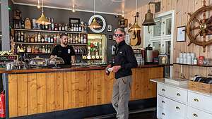 Herb in Kaffi LaraAfter leaving Djupivogur, we continued along the Ring Road (Route 1) towards the town of Egilsstaðir, where we would leave the Ring Road to take a side trip to the Seydisfjordur, considered to be one of the most beautiful villages in East Iceland.
We weren’t very far from Djupivogur before Google Maps directed us onto a gravel road. This road didn’t seem right, so we stopped to look at the map. Google does this sometimes, picking a shorter distance route, regardless of road conditions.
Oh, this was the infamous road 939 that went over Öxi Pass that McRent had warned us about - “absolutely do not go on that road.”
.thumbnail.jpg) Iconic blue churchSo, we turned around and got back on the Ring Road, which weaved its way among the fjords - quite a bit longer, but much more scenic and safe.
Iconic blue churchSo, we turned around and got back on the Ring Road, which weaved its way among the fjords - quite a bit longer, but much more scenic and safe.
When we got to the town of Egilsstaðir, we left the Ring Road and turned onto Road 93 towards Seydisfjordur. This was quite a road, winding and climbing over a 2,000 foot mountain pass, with snow all around us. It felt like we had entered a winter wonderland.
We later found out that this is one of the highest paved roads in Iceland, and they are even thinking of building a tunnel through the mountain pass, as the road is often impassable in winter. The scenery certainly was beautiful though.
Before exploring the village, we stopped to have lunch at Kaffi Lara, a cozy restaurant and bar right near Rainbow Street. The food and ambience was great.
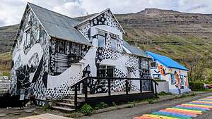 Street Art along the Rainbow RoadWe got to talking to our waiter who told us he was from Barcelona, but comes here to work in the summer. Summer is a relative term, as he said the town was totally cut off from the rest of Iceland until a few weeks ago because of snow, reinforcing that need for a tunnel through the mountain pass on 93.
After lunch, we set out to explore the town, which we knew wouldn’t take very long because it is quite small, with only 700 inhabitants.
Our first stop was right outside our restaurant - the iconic Seydisfjordur blue church with a rainbow road leading towards it - just like Reykjavik's Rainbow Road leading towards Hallgrímskirkja, but on a much smaller scale. It’s a very popular spot to take a photograph, so we had to wait our turn.
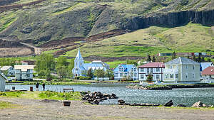 SeydisfjordurTiny Seydisfjordur is surprisingly one of Iceland's cultural centers and attracts artists from around the country. In addition, there is an art academy that attracts young people from across Iceland and abroad.
So with all these artists, as you would expect, the buildings along the Rainbow road were covered with murals.
The street is also lined with many bars and cafes, and it is one of the liveliest parts of Seydisfjordur.
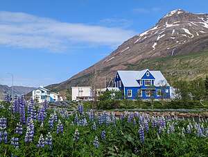 SeydisfjordurThe town has a nice harbor located at the innermost point of a 10-mile-long fjord. In the early 20th century it was a booming town of Norwegian-run herring fisheries, and many of the buildings survive from this time period. As herring stocks declined, so did the town.
As with many other Icelandic villages, the economy of the town is now driven by tourism.
We took a stroll around the harbor admiring the colorful houses, backed by snow-capped mountains and cascading waterfalls. And the lupine! Lots and lots of beautiful bright blue lupine!
And all because of one man, Hákon Bjarnason, who back in 1945 was sent to Alaska as a representative of a committee set up to revegetate areas of Iceland. Guess what plant he picked. That’s right lupine, and today it covers and beautifies so much of Iceland. Thank you Hákon.
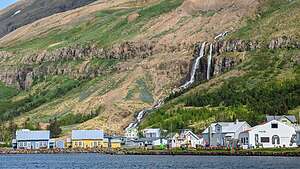 SeydisfjordurIn December of 2020, tragedy hit the village when some of those beautiful hills overlooking the town came tumbling down in a landslide, destroying more than 10 buildings.
It was the most damaging landslide ever to hit a town in Iceland. The destruction and economic loss was enormous, but miraculously there were no casualties.
The townspeople came together in a massive clean-up and rebuild effort to save their beloved village.
Seydisfjordur definitely earns its distinction as the most beautiful village in East Island, as well as the most public-spirited and heroic.
- ‹ previous
- 13 of 30
- next ›
Seydisfjordur location map in "high definition"
Javascript is required to view this map.
