- Home
- About
- Map
- Trips
- Bringing Boat West
- Migration West
- Solo Motorcycle Ride
- Final Family XC Trip
- Colorado Rockies
- Graduates' XC Trip
- Yosemite & Nevada
- Colorado & Utah
- Best of Utah
- Southern Loop
- Pacific Northwest
- Northern Loop
- Los Angeles to NYC
- East Coast Trips
- Martha's Vineyard
- 1 Week in Quebec
- Southeast Coast
- NH Backpacking
- Martha's Vineyard
- Canadian Maritimes
- Ocracoke Island
- Edisto Island
- First Landing '02
- Hunting Island '02
- Stowe in Winter
- Hunting Island '01
- Lake Placid
- Chesapeake
- Provincetown
- Hunting Island '00
- Acadia in Winter
- Boston Suburbs
- Niagara Falls
- First Landing '99
- Cape Hatteras
- West Coast Trips
- Burning Man
- Utah Off-Roading
- Maui
- Mojave 4WD Course
- Colorado River Rafting
- Bishop & Death Valley
- Kauai
- Yosemite Fall
- Utah Off-Road
- Lost Coast
- Yosemite Valley
- Arizona and New Mexico
- Pescadero & Capitola
- Bishop & Death Valley
- San Diego, Anza Borrego, Joshua Tree
- Carmel
- Death Valley in Fall
- Yosemite in the Fall
- Pacific Northwest
- Utah Off-Roading
- Southern CA Deserts
- Yosemite & Covid
- Lake Powell Covid
- Eastern Sierra & Covid
- Bishop & Death Valley
- Central & SE Oregon
- Mojave Road
- Eastern Sierra
- Trinity Alps
- Tuolumne Meadows
- Lake Powell Boating
- Eastern Sierra
- Yosemite Winter
- Hawaii
- 4WD Eastern Sierra
- 4WD Death Valley +
- Southern CA Deserts
- Christmas in Tahoe
- Yosemite & Pinnacles
- Totality
- Yosemite & Sierra
- Yosemite Christmas
- Yosemite, San Diego
- Yosemite & North CA
- Seattle to Sierra
- Southwest Deserts
- Yosemite & Sierra
- Pacific Northwest
- Yosemite & South CA
- Pacific Northwest
- Northern California
- Southern Alaska
- Vancouver Island
- International Trips
- Index
- Tips
- Books
- Photos/Videos
- Search
- Contact
Anza-Borrego State Park, CA
Thursday, March 25, 2021 - 12:00pm by Lolo
326 miles and 6 hours from our last stop - 3 night stay
Travelogue
Day1 – Borrego Springs Resort and Spa
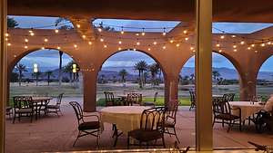 Borrego Springs Resort and Spa dining roomWe got to the park just in time to stop at the Visitor Center to get information about 4WD road conditions so that we could plan our next couple of days. It was a bit late to start looking for campsites along one of the washes, so we decided to spend the night at the Borrego Springs Resort and Spa. From there we would plan our next couple of days off-roading. We must be getting soft.
The hotel was very nice and quite luxurious compared to what could have been for this evening. The resort restaurant had just reopened, so we were happy that we could have dinner without having to get back into the car.
It was our very first indoor dining experience, but there was only one other table in the large dining room occupied, so I felt very comfortable. Apparently the etiquette for indoor dining is that you wear your mask until you sit down, but then you can take it off. However, out of habit, any time the waitress came near, I grabbed for it. I just felt it was the courteous thing to do. The setting was very nice and the food was pretty good. The menu was a bit limited because they were just starting up again. It must be really hard for these restaurants to respond to the closures and re-openings.
Day 2 – Coyote Canyon and Sheep Canyon
.thumbnail.jpg) Alternative to bushwhackingThe next morning, I stepped out onto our patio and saw about a dozen ladies being led in a aqua aerobics class in the pool below us. I was getting a little embarrassed, as we had told our friends that we were going on a remote camping trip in our truck to the desert and the mountains. We would eventually get there. For now, we were enjoying the novelty or normal life.
Alternative to bushwhackingThe next morning, I stepped out onto our patio and saw about a dozen ladies being led in a aqua aerobics class in the pool below us. I was getting a little embarrassed, as we had told our friends that we were going on a remote camping trip in our truck to the desert and the mountains. We would eventually get there. For now, we were enjoying the novelty or normal life.
The following morning, based on a knowledgeable friend’s recommendation, we let some air out of our tires and took the 4WD road through Coyote Canyon to Sheep Canyon, where we were able to get a campsite in the primitive campground. It was about a 14-mile drive of sandy and rocky roads.
One of the prime motivators for camping here was a hike described in the Anza-Borrego Desert Region guidebook (referred to as Bible by the Visitor Center staff). On page 98, the author described a 1-mile (RT) hike which went from the campground to a lovely spring grotto with a 20-foot waterfall and tree-shaded pool. It sounded lovely.
To his credit, he did describe the trail as steep and rugged, requiring several stream crossing, and scrambling over large boulders. Oh, and thorny plants all over, very anxious to poke you in the same of self defense. There was no real obvious trail. Occasionally, we would come across a cairn to encourage us that we were going in the right direction.
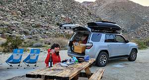 Camping in Sheep CanyonFinally we found it, but with the water levels being low this spring, the waterfall was not quite as inspirational as the photo in the guidebook. Still, it was quite nice.
I was not looking forward to bushwhacking through more cacti and climbing over boulders, so we decided to just get our feet wet and follow the stream down to the campground. It was a fairly good plan, with just one minor faux pas, when I misjudged the depth of the stream when stepping off a rock into it and did a faceplant. Fortunately, the only thing hurt was my pride. I was now totally soaked, but the day was warm enough to make it refreshing. Plus, that would be my shower for the day.
We managed to get back to the campsite without any further mishaps, and had a nice evening cooking out and sipping wine while watching the sun set.
Day 3 – Fish Creek Wash, Olla Wash, and the Mud Palisades
.thumbnail.jpg) Split Mountain GorgeThe next morning we watched the sun come up and then headed back, continuing along through Sheep Canyon and Coyote Canyon back to the Visitor Center.
Split Mountain GorgeThe next morning we watched the sun come up and then headed back, continuing along through Sheep Canyon and Coyote Canyon back to the Visitor Center.
Our plan for today was to explore and spend the night in Fish Creek Wash, which we had been to and liked on a previous trip, seeing some new things we had not had time for the last time.
From the Visitor Center it was about a 40-minute drive (on asphalt) to the beginning of the Fish Creek Wash. To get there, we drove on Route 78 to the town of Ocotillo Wells. From there, we went south on Split Mountain Road for about 8 miles to the beginning of the Wash. At the entrance, we reset our odometer to 0.0, so that we could follow the mile by mile description of the drive in Lindsay’s “Anza-Borrego Desert Region Guide.”
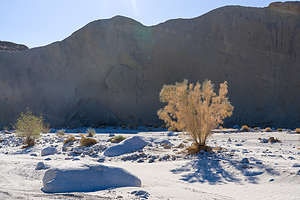 Along the Olla WashAfter about a mile and a half of relatively easy driving, we entered Split Mountain Gorge, a narrow cut in the mountains where cliff walls, several hundred feet high, towered above us. The split separates the Vallecito Mountains on the right and the Fish Creek Mountains on the left. It’s one of my favorite spots along the wash.
At mile 3.8, we stopped to admire the fascinating anticlines on the canyon walls, where the rock layers had been bent and twisted into U-shaped bows and curves by tectonic activity millions of years ago. They were beautiful.
At mile 4.4 is the trailhead for the very popular 1.3-mile (RT) hike to the Split Mountain Wind Caves, where there is a collection of sandstone formations with wind-eroded pockets, some of which are large enough to crawl through and sit in. It is truly worth doing, but since we had done it last time and wanted to see some new sights, we continued on.
We continued along the Wash, bypassing the choice at mile 7.2 for the Loop Wash spur. At mile 10.7 we came to an interesting sandstone rock formation known as the Layer Cake, because of its multi-colored bands of green and gray.
.thumbnail.jpg) Lolo amongst the ChollaA little bit further, at mile 12.5, we reached Sandstone Canyon, a high wall, narrow slot canyon that was drivable until 1992, when thousands of tons of debris came tumbling down near its mouth. You can park at the entrance and walk for about a half mile into the canyon. We did that last time, so instead we continued on. This was now all new territory for us.
Lolo amongst the ChollaA little bit further, at mile 12.5, we reached Sandstone Canyon, a high wall, narrow slot canyon that was drivable until 1992, when thousands of tons of debris came tumbling down near its mouth. You can park at the entrance and walk for about a half mile into the canyon. We did that last time, so instead we continued on. This was now all new territory for us.
At mile 13.2, we came to the turn off for the Olla Wash, where we planned to camp that night. For now though, we passed it and drove another 0.4 miles to the Fish Creek Overlook, where we scampered up to an awesome view across the Fish Creek and Carrizo Badlands.
From there we drove back 0.4 miles and entered the Olla Wash, which goes for 2 miles, ending at the very impressive Mud Palisades. The ranger at the Visitor Center had told us that this was one of her favorite places in the park, so since it was something we hadn’t seen, we decided to try it.
During the 2 mile drive, we scouted out possible campsites for the night. This was a very lightly traveled Wash, so there were several good options. We chose one that was set against a colorful rock backdrop with my very own cholla garden.
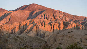 Morning light on the Mud PalisadesFrom there we walked the mile to the Mud Palisades, but unfortunately they were already in the shade, so we decided to come back at sunrise, during the golden hour.
Back at the campsite, we read, sipped wine, strolled amongst the cholla, and watched a full moon rise over the rocks behind us, without another soul in miles.
The next morning we rose early, skipped breakfast and coffee, and drove the 1 mile to the Mud Palisades to catch the sunrise. As we had hoped, the dull tans of yesterday afternoon had become a brilliant red. I could see how they got their name, as their deeply eroded cliff faces, made of mudstone, made them look like the defensive walls of an old fortress or castle.
Description
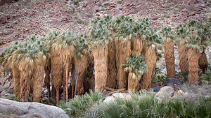 Borrego Palms OasisWith over 600,000 acres, Anza Borrego is the largest state park in the California state park system and the largest desert state park in the U.S. Its spectacular and undeveloped Colorado Desert scenery extends from the edge of the coastal mountains east to the Salton Sea and south almost to the Mexican border. The park is located about 2 hours northeast of San Diego
The elevation in the park ranges from just 200 feet near the eastern edge to 6,200 feet, resulting in a variety of ecosystems and a temperature range as high as 30 degrees.
Major activities in the park include:
- Four-wheel driving on its nearly 500 miles of dirt and rocky roads (of varying difficulty)
- Mountain biking along those same four-wheel drive trails
- Hiking along its 50 miles of trails with a variety of scenery palm oases, waterfalls, slot canyons, badlands, desert gardens, etc.
- Wildlife viewing - bighorn sheep, deer, bobcats, coyotes, mountain lions, Jackrabbits, desert cottontails, 50 species of lizards and snakes, hawks, etc.
- Enjoying the spring wildflowers
- Camping – there are 12 campgrounds inside the park, but it is one of the few California parks that allows open camping throughout its 600,000 acres
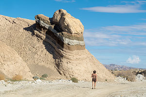 Layer Cake formation in Fish Creek WashThe small town of Borrego Springs lies at the center of the park and has ample services – lodging, restaurants, gas, grocery store, etc.
The park’s Visitor Center and the Borrego Palms Campground are just 5 miles west of the town of Borrego Springs. Be sure to pick up a copy of their ‘At Home’ magazine, which is a great source of things to do in the park.
- ‹ previous
- 3 of 9
- next ›
Anza-Borrego State Park location map in "high definition"
Javascript is required to view this map.
