- Home
- About
- Map
- Trips
- Bringing Boat West
- Migration West
- Solo Motorcycle Ride
- Final Family XC Trip
- Colorado Rockies
- Graduates' XC Trip
- Yosemite & Nevada
- Colorado & Utah
- Best of Utah
- Southern Loop
- Pacific Northwest
- Northern Loop
- Los Angeles to NYC
- East Coast Trips
- Martha's Vineyard
- 1 Week in Quebec
- Southeast Coast
- NH Backpacking
- Martha's Vineyard
- Canadian Maritimes
- Ocracoke Island
- Edisto Island
- First Landing '02
- Hunting Island '02
- Stowe in Winter
- Hunting Island '01
- Lake Placid
- Chesapeake
- Provincetown
- Hunting Island '00
- Acadia in Winter
- Boston Suburbs
- Niagara Falls
- First Landing '99
- Cape Hatteras
- West Coast Trips
- Burning Man
- Utah Off-Roading
- Maui
- Mojave 4WD Course
- Colorado River Rafting
- Bishop & Death Valley
- Kauai
- Yosemite Fall
- Utah Off-Road
- Lost Coast
- Yosemite Valley
- Arizona and New Mexico
- Pescadero & Capitola
- Bishop & Death Valley
- San Diego, Anza Borrego, Joshua Tree
- Carmel
- Death Valley in Fall
- Yosemite in the Fall
- Pacific Northwest
- Utah Off-Roading
- Southern CA Deserts
- Yosemite & Covid
- Lake Powell Covid
- Eastern Sierra & Covid
- Bishop & Death Valley
- Central & SE Oregon
- Mojave Road
- Eastern Sierra
- Trinity Alps
- Tuolumne Meadows
- Lake Powell Boating
- Eastern Sierra
- Yosemite Winter
- Hawaii
- 4WD Eastern Sierra
- 4WD Death Valley +
- Southern CA Deserts
- Christmas in Tahoe
- Yosemite & Pinnacles
- Totality
- Yosemite & Sierra
- Yosemite Christmas
- Yosemite, San Diego
- Yosemite & North CA
- Seattle to Sierra
- Southwest Deserts
- Yosemite & Sierra
- Pacific Northwest
- Yosemite & South CA
- Pacific Northwest
- Northern California
- Southern Alaska
- Vancouver Island
- International Trips
- Index
- Tips
- Books
- Photos/Videos
- Search
- Contact
Rainbow Basin National Natural Landmark, CA
Monday, March 29, 2021 - 12:30pm by Lolo
80 miles and 2 hours from our last stop - 1 night stay
Travelogue
 Along the Rainbow Basin Loop RoadWe had been through Barstow half a dozen times on our way to Nevada and Utah, but had never taken the time to visit Rainbow Basin, just an 8 miles north of town. Well, this time it was our destination for the day, and it was long overdue.
Despite its close proximity to Barstow, it is totally remote and undeveloped. There isn’t even a visitor center. The only evidence of man is the unpaved 4.6-mile loop BLM road that winds through the colorful gorges. Before the start of the loop road is the Owl Canyon campground, which is first-come-first-served and costs $6.
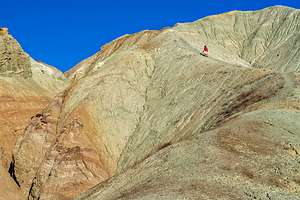
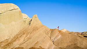
The Basin is part of the Calico Peaks range in the Mojave Desert. Noted for its colorful and interestingly shaped sedimentary rock formations, it was named a National Natural Landmark in 1966.
When we arrived, we decided to take a reconnaissance drive along the one-way, 4.6-mile dirt loop road, scouting at good spots to return to during the golden hour. The first 2 miles were definitely the most photogenic.
 What goes up, must come downWe returned to the Owl Campground and took one of the 22 first-come-first-served spots. There were plenty of spots available. After lunch, we hiked a mile or so up the wash that began at the edge of the campground. By the time we got back to our campsite, the wind had picked up significantly, making it a bit difficult to just sit at the campsite.
So, we got back in the truck and set out on the scenic loop road again. What a difference the low light can make. We spent the next two hours, scampering up the now radiant rock formations, or more correctly, Herb made me scamper up them while he stayed below photographing me. My job was to provide a sense of scale. The smaller I was, the better.
By early evening it had gotten so windy that we didn’t know how we could possibly cook dinner at the campsite, so we decided to go back to Barstow to grab dinner and a hotel room.
- ‹ previous
- 6 of 9
- next ›
Rainbow Basin National Natural Landmark location map in "high definition"
Javascript is required to view this map.
