- Home
- About
- Map
- Trips
- Bringing Boat West
- Migration West
- Solo Motorcycle Ride
- Final Family XC Trip
- Colorado Rockies
- Graduates' XC Trip
- Yosemite & Nevada
- Colorado & Utah
- Best of Utah
- Southern Loop
- Pacific Northwest
- Northern Loop
- Los Angeles to NYC
- East Coast Trips
- Martha's Vineyard
- 1 Week in Quebec
- Southeast Coast
- NH Backpacking
- Martha's Vineyard
- Canadian Maritimes
- Ocracoke Island
- Edisto Island
- First Landing '02
- Hunting Island '02
- Stowe in Winter
- Hunting Island '01
- Lake Placid
- Chesapeake
- Provincetown
- Hunting Island '00
- Acadia in Winter
- Boston Suburbs
- Niagara Falls
- First Landing '99
- Cape Hatteras
- West Coast Trips
- Burning Man
- Utah Off-Roading
- Maui
- Mojave 4WD Course
- Colorado River Rafting
- Bishop & Death Valley
- Kauai
- Yosemite Fall
- Utah Off-Road
- Lost Coast
- Yosemite Valley
- Arizona and New Mexico
- Pescadero & Capitola
- Bishop & Death Valley
- San Diego, Anza Borrego, Joshua Tree
- Carmel
- Death Valley in Fall
- Yosemite in the Fall
- Pacific Northwest
- Utah Off-Roading
- Southern CA Deserts
- Yosemite & Covid
- Lake Powell Covid
- Eastern Sierra & Covid
- Bishop & Death Valley
- Central & SE Oregon
- Mojave Road
- Eastern Sierra
- Trinity Alps
- Tuolumne Meadows
- Lake Powell Boating
- Eastern Sierra
- Yosemite Winter
- Hawaii
- 4WD Eastern Sierra
- 4WD Death Valley +
- Southern CA Deserts
- Christmas in Tahoe
- Yosemite & Pinnacles
- Totality
- Yosemite & Sierra
- Yosemite Christmas
- Yosemite, San Diego
- Yosemite & North CA
- Seattle to Sierra
- Southwest Deserts
- Yosemite & Sierra
- Pacific Northwest
- Yosemite & South CA
- Pacific Northwest
- Northern California
- Southern Alaska
- Vancouver Island
- International Trips
- Index
- Tips
- Books
- Photos/Videos
- Search
- Contact
Blue Ridge Parkway to Ashville, NC
Monday, April 27, 2015 - 2:00pm by Herb
210 miles and 8 hours from our last stop - 2 night stay
Travelogue
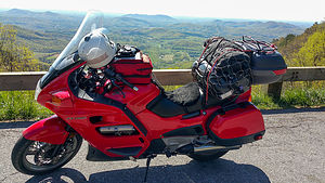 ST 1100 at Cumberland Knob Recreation area overlookAfter two nights on the road, I was beginning to get into a bit of a rhythm. The "laundry", consisting of a pair of e-officio underwear, wool socks, and a long sleeve wool shirt which were washed in the sink with shampoo, and dried overnight using the motel rooms heater. Nourishment in the form of 2 packs of Maple and Brown Sugar Oatmeal and a mug of coffee were prepared using hot water from the microwave or coffee maker.
My clothes were contained in a black waterproof "river bag" that was strapped on top of a waterproof black Ortlieb bag which contained all the soft camping gear. (Big Agnes UL3 Tent, Mountain Hardware Ultralamina 32 sleeping bag, luxurious X-Ped large sleeping pad, and a Kermit camping chair.)
The rest of the bike was packed as follows...
- Left side saddlebag inner compartment - Nalgene water bottle, Jetboil cookset and Jetboil stove, Starbucks Italian Coffee, and a Nissan thermos.
- Left side saddlebag outer compartment - Propane, Bagels, Peanut butter, Quaker instant oatmeal, and a partial roll of paper towels
- Right side saddlebag inner compartment - Small soft cooler with beer, water bottles, wine in Arizona green tea bottles
- Right side saddlebag outer compartment - Progresso canned soup, purple mist Gatorade, Triscuits, Knorrs Rice Sides, Mountain House dinners, and a bag of cashews
- The rear Givi bag contained my Canon G12 camera, a Go-Pro, a small laptop, AAA maps of the country by state, and my Gerbing Heated Jacket when it was not needed to be worn.
- The tankbag contained my chargers for the phone, headset, and GPS, as well as a cover for the entire bike. A map for the current section was visible in the top clear pouch.
My pre-flight routine had also been refined somewhat.
- Start the bike and let it warm up while finishing the packing process
- Get Google Maps on the phone positioned to the next destination, start the Strava application to record the gpx track, and create a playlist for the day on Google Music
- Check tires, lights, and all controls
- Plug in heated jacket and adjust the vents on my Aerostich Darien Jacket for the forecasted temperatures in the early morning.
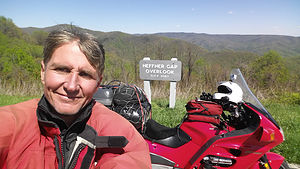 Bad Helmet Hair SelfieToday would be a great ride. I was heading down some of the most scenic parts of the Blue Ridge Parkway and Lorry had convinced me that I should treat myself with a few days in Ashville so I could visit the Biltmore Estate. Living in NJ we had often visited the Mansions of Newport Rhode Island, but had not yet visited the largest of the Vanderbilt Mansions. I wished that Lorry could be here with me, but I promised to take a lot of photos so she could vicariously enjoy the tour with me.
On the road one again, I enjoyed the two lane Blue Ridge Parkway that meandered down the ridge of the mountains past rolling hills and occasional farm fields. After 45 minutes I pulled over at the Cumberland Knob Recreation area overlook and photographed my trusty steed with the mountains in the distance.
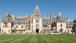 Biltmore EstateAs I continued on, I got a call from Lolo with a suggestion for lunch. She had grown somewhat concerned with my diet so far on this trip, and had found what she thought might be a more healthy fast food alternative. By tracking my projected progress she directed me to a Chipotle in Boone, N.C. At the time I had never eaten in a Chipotle so I headed off the parkway to enjoy a "healthy" mexican style lunch. I have to say that it was tasty,, but by the time I had finished adding sour cream and other embellishments I am sure it was a high caloric meal of with dubious health qualities. (This was before the recent norovirus outbreak would have made this choice of dining venue even more questionable.)
Fueled up, I headed back to the Parkway and almost immediately pulled over to stroll around the Moses H. Cone Memorial Park. A few photos, and the next pullout was at the Hefner Gap Overlook at elevation 3067 where a "bad helmet hair" selfie was taken. I had already been over the Pilot Ridge Overlook with an elevation of over 4000' so the heated jacket was dialed up even though I was in North Carolina and had thought I would be enjoying warmer weather.
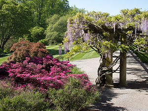 Biltmore Estate GardensThe Ridge Junction at 5160' was the next stop and then off to the Craggy Gardens Visitor for a quick pee break. I met a couple of older guys there on BMW GS 1200's that were on their way to a BMW camping event so they could ride the "Tail of the Dragon" near Deals Gap. For those unfamiliar with this road, with "318 curves in 11 miles" it is considered one of the top 5 rides in the world, and one that I would try to get to in a few days.
After a few more miles I managed to navigate to the Super 8 in Ashville where I would spend the next two nights, allowing for a "rest day" where I could tour the Biltmore estate.
Up early in the morning I rode for the first time on this trip, without the extra burden of all my extra luggage. It felt liberating and simpler even as I navigated my way to the ticket area of the Biltmore Estate. Lorry had researched this and already purchased my ticket for a Tour of the Mansion at 11:30.
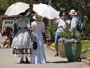 Women in Period Costumes at Biltmore EstateStrolling the beautiful gardens and the interior of the mansion I started to feel a bit lonesome for the companionship of my lifelong partner. When riding long distances on the motorcycle I have no longings since I know that Lorry would not actually enjoy the experience as much as I do. However, I know that she would enjoy a good Mansion Tour and stroll in the gardens so I had to make do with a phone call where I tried to give her the best virtual description I could.
The Mansion was as impressive as expected, but the volume of tourists made it a bit crowded. Also, I had become accustomed to going my own way as a solo traveler and now had to adapt to being just another of the many cattle herded around from room to room.
Afterwards I had a stroll in the gardens and sat down on a bench by the lake for a snack. My phone rang and Lolo asked me how I was enjoying the view (she could see me location on Google maps). That cheered me up a bit as I described the scene in front of me.
I took a bit of a detour while leaving the estate to enjoy the grounds, stopped at a Trader Joe's in Asheville to replenish my stores, and got back to my room in time to rest up for the next days journey west.
- ‹ previous
- 3 of 16
- next ›
Blue Ridge Parkway to Ashville location map in "high definition"
Javascript is required to view this map.
