- Home
- About
- Map
- Trips
- Bringing Boat West
- Migration West
- Solo Motorcycle Ride
- Final Family XC Trip
- Colorado Rockies
- Graduates' XC Trip
- Yosemite & Nevada
- Colorado & Utah
- Best of Utah
- Southern Loop
- Pacific Northwest
- Northern Loop
- Los Angeles to NYC
- East Coast Trips
- 1 Week in Quebec
- Southeast Coast
- NH Backpacking
- Martha's Vineyard
- Canadian Maritimes
- Ocracoke Island
- Edisto Island
- First Landing '02
- Hunting Island '02
- Stowe in Winter
- Hunting Island '01
- Lake Placid
- Chesapeake
- Provincetown
- Hunting Island '00
- Acadia in Winter
- Boston Suburbs
- Niagara Falls
- First Landing '99
- Cape Hatteras
- West Coast Trips
- Maui
- Mojave 4WD Course
- Colorado River Rafting
- Bishop & Death Valley
- Kauai
- Yosemite Fall
- Utah Off-Road
- Lost Coast
- Yosemite Valley
- Arizona and New Mexico
- Pescadero & Capitola
- Bishop & Death Valley
- San Diego, Anza Borrego, Joshua Tree
- Carmel
- Death Valley in Fall
- Yosemite in the Fall
- Pacific Northwest
- Utah Off-Roading
- Southern CA Deserts
- Yosemite & Covid
- Lake Powell Covid
- Eastern Sierra & Covid
- Bishop & Death Valley
- Central & SE Oregon
- Mojave Road
- Eastern Sierra
- Trinity Alps
- Tuolumne Meadows
- Lake Powell Boating
- Eastern Sierra
- Yosemite Winter
- Hawaii
- 4WD Eastern Sierra
- 4WD Death Valley +
- Southern CA Deserts
- Christmas in Tahoe
- Yosemite & Pinnacles
- Totality
- Yosemite & Sierra
- Yosemite Christmas
- Yosemite, San Diego
- Yosemite & North CA
- Seattle to Sierra
- Southwest Deserts
- Yosemite & Sierra
- Pacific Northwest
- Yosemite & South CA
- Pacific Northwest
- Northern California
- Southern Alaska
- Vancouver Island
- International Trips
- Index
- Tips
- Books
- Photos/Videos
- Search
- Contact
Eastern Sierra (North of Mono Lake), CA
Friday, August 29, 2014 - 2:00pm by Lolo
91 miles and 2 hours from our last stop - 2 night stay
Travelogue
 Bodie State Historic ParkAfter a wonderful kayaking experience on Mono Lake, we headed north on US 395 for about 50 miles to set up base camp at the Willow Springs RV Park in the town of Bridgeport. As I mentioned in a previous post, setting up of a base camp, and then using our tow vehicle to get around was really working for us. It was very liberating not to have to drag the motorhome with us everywhere we went.
One of the reasons we chose Willow Springs RV Park was that it is close to the two places we were interested in visiting in the area: Bodie State Historic Park and the Travertine Hot Springs.
The next morning we set out for Bodie State Historic Park, the turnoff for which was just a mile south of our campground. From there it was 13 miles through what really looked like cowboy country. The last 3 miles were on a bumpy, dirt road, so once again we were grateful that we were driving a Subaru rather than a Lazy Daze.
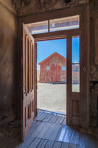 View from Doorway at BodieWe actually arrived before the park opened, so we got in line behind two other early birds at the entry booth. At 9:00 am sharp, a Park Ranger strolled over to the flagpole, raised the California flag, returned to the booth, and greeted us with a hardy, “Welcome to Bodie.”
Getting there early was a good idea, because ghost towns feel more ghostlike when you have them to yourselves rather than sharing them with a lot of other tourists, which did happen about an hour later.
Before coming here, I kind of expected one of those touristy manufactured cowboy towns that you encounter in the West, but this was the real deal, a genuine gold-mining boom town that had gone bust.
I always find visiting a place much more meaningful when I know its history, so I diligently read the informative brochure, and this is what I learned:
Gold was first discovered in the area (actually by Mono Lake) in1859 by W.S. Bodey, who unfortunately froze to death before he got a chance to enjoy his new-found wealth. The town, with a minor spelling change, was named for him. After a slowdown in the 1860s, in the mid-1970s an even richer strike was made by what became known as the Standard Mining Company, and thousands of prospectors hoping to make it rich rushed to Bodie. By 1879 the town had a population of about 10,000 people and more than 2,000 buildings, primarily general stores, dance halls, and saloons to keep the miners supplied and entertained. Bodie soon developed a reputation for wildness and lawlessness.
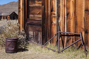 Bodie Rusted BicycleIn addition to the miners, hundreds of Chinese workers also flocked to Bodie and profited from the boom by providing for the needs of the miners with wood, charcoal, vegetables, laundries, and more. The Chinese created a town within a town so that they could maintain their own customs and traditions. There is an old Chinese residence still standing in old Chinatown at the end of King Street.
However, by 1881, the mines were depleted and miners and business people left Bodie to follow the next strike. By 1886, the town’s population had fallen to 1,500 people. In the 1890s, the use of electricity as a source of cheap power made mining here profitable again and temporarily boosted it. However, a fire in 1932 destroyed 90% of the town.
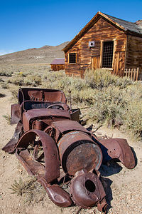 Bodie Rusted Car with CabinBodie faded into a ghost town in the 1940s. Fortunately, in 1962, the town was designated a National Historic Site and a State Historic Park. The town has been preserved in a state of “arrested decay.” The interiors of the buildings are maintained as they were left, still furnished and stocked with goods.
We spent an enjoyable two hours, especially the one before everyone else arrived, wandering the deserted streets, peeking in windows, and reading the informative brochure that explained each building. It really was a very poignant experience imagining the lives of those that lived, played, worked, and died here so many years ago.
After leaving Bodie, we headed north on US 395 towards the town of Bridgeport to soak in the Travertine Hot Springs. It wasn’t too hard to find – just a right onto Jack Sawyer Road and then left again on a marked, but somewhat rutted, dirt road.
Although Herb and I had soaked in pools fed by hot springs– Ouray, Banff, and Bend come to mind – we had never been to a “natural” hot spring, so we were pretty excited about adding a new experience to our list.
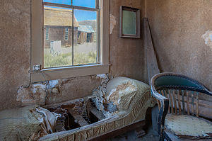 Bodie Interior Couch with Window ViewThe first hot spring we saw was adjacent to the parking lot. This one was partially developed with a man-made lining and rugs placed around it to cushion the hard surface. I had no intention of sitting at the edge of a parking lot, so we strolled down the trail a short distance to the lower pools, which are fed from water trickling over the ridge of a colorful rock formation. The rock was stained with beautiful tan, cream, and rust streaks from the “travertine” limestone that is continually being deposited by the mineral-laden hot springs above.
There were three pools below, with water flowing from one pool to the next, decreasing in temperature as it went along. The pool on the right had stone sides to sit on and was about 105 degrees, the pool in the middle also had stone sides and was about 100 degrees, and the pool on the left was mostly mud and only about 90 degrees. Each of the pools’ bottom were covered in soft, mushy mud, which felt rather soothing to the skin.
There were two couples already in the rightmost pool, so Herb and I tried each of the two on the left. I wasn’t crazy about sitting directly in the mud, so I chose the middle pool, which was also warmer than the muddy one. This one was “just right.”
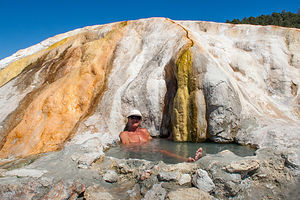 Travertine Hot Spring with HerbWe weren’t the only ones that thought about coming here today, and throughout the afternoon probably at least 30 people or so passed through – some just to look, but most to sit for awhile in the warm sulfuric waters.
When it got a bit too crowded, we walked a short distance to find a more private, primitive pool. The whole area around the springs is very active geothermally, so new springs are continuously erupting and new pools forming.
Although I liked the middle pool by the rock formation where I didn’t have to sit directly in the mud, Herb preferred having his own hot spring to himself, where he could also soak up the beautiful views of the Sierra in the distance.
It had been a lovely day, much more relaxing and less physically demanding than the prior two weeks had been. The slower pace felt good, at least for awhile.
Description
The Eastern Sierra Scenic Byway, officially known as Highway 395, runs the entire length of the Sierra Nevada Range, from south of Lone Pine to Lake Tahoe and beyond. The scenery along the way is breathtaking and full of variety – snow covered mountains, incredible lakes, ancient bristlecone forests, natural hot springs, and so much more.
I have broken up our journey along the Scenic Byway into three stops:
• South of Mono Lake
• Mono Lake
• North of Mono Lake
The following is a description of a few of the stops we enjoyed along the Eastern Sierra northern section:
Bodie State Historic Park
 Bodie Store InteriorBodie State Historic Park is a genuine California gold-mining ghost town. The town rose to prominence when mining along the western slope of the Sierra declined, and prospectors moved to the eastern side to search for gold. A huge strike in Virginia City, the Comstock Lode, brought a wild rush to the high desert country along the eastern Sierra.
In 1859, W.S. Bodey and E. S. “Black” Taylor stumbled upon gold in the hills north of Mono Lake, amounting to millions of dollars in gold and silver. Unfortunately, Bodey froze to death in a blizzard while returning with supplies and never got to enjoy his new-found wealth. The town, with a slight spelling change, is named for him.
Things slowed down for a bit in the 1860s, but then in the mid-1870s a rich strike was made by the Standard Mining Company in the Bodie Hills. Word spread, sparking a rush of people to Bodie. By 1879 the town had a population of about 10,000 people and more than 2,000 buildings, primarily general stores, dance halls, and saloons to keep the miners supplied and entertained. Bodie soon developed a reputation for wildness and lawlessness.
 Bodie Buildings with Yellow FlowersHundreds of Chinese workers also flocked to Bodie and profited from the boom by providing for the needs of the miners with wood, charcoal, vegetables, laundries, and more. The Chinese created a town within a town so that they could maintain their own customs and traditions.
However, by 1881, the mines were depleted and miners and business people left Bodie to follow the next strike. By 1886, the town’s population had fallen to 1,500 people. In the 1890s, the use of electricity as a source of cheap power made mining here profitable again and temporarily boosted it. However, a fire in 1932 destroyed 90% of the town.
Bodie faded into a ghost town in the 1940s. Fortunately, in 1962, the town was designated a National Historic Site and a State Historic Park. Today visitors can walk the streets of this deserted town, which has been preserved in a state of “arrested decay.” The interiors of the buildings are maintained as they were left, still furnished and stocked with goods.
To get there, take U.S. Hwy. 395 to State Hwy. 270 and drive 10 miles east until the paved road ends, then continue for 3 miles of an unpaved dirt road.
Travertine Hot Springs
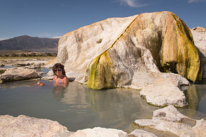 Travertine Hot Spring with LoloThere are many natural hot springs in the Sierra, but the Travertine Hot Springs are one of the prettiest and the easiest to get to. They are located just south of the town of Bridgeport along Route 395. To reach the springs, turn onto Jack Sawyer Road, then left again onto a marked, but somewhat rutted, dirt road.
There are several pools at Travertine. Right next to the parking area is a developed pool, which is the hottest of the pools in the area. There were even rugs placed around it to cushion the hard surface.
A short way down the trail are the lower three pools, which are fed from water trickling over the ridge of a colorful rock formation that rises above them. The beautiful tan, cream and rust colors of the rock are the result of a form of limestone, called “travertine” that is deposited by the mineral-laden hot springs. The water flows from one pool to the next decreasing in temperature as it goes along. The first pool is about 105 degrees, while the last, which is the largest and shallowest, is only about 90 degrees.
 Hot Spring PoolA little past the main pools there are a few more primitive pools that are much more private. The whole area around the springs is very active geothermally, and new springs are continuously erupting.
There are wonderful views of the Sierra while you bathe in one of its pools, sitting along a rocky ledge or in the mud that lines their bottoms. The mud is slightly sulfuric and soothing to the skin.
The area is designated “clothing optional,” but most people wear bathing suits.
- ‹ previous
- 5 of 8
- next ›
Eastern Sierra (North of Mono Lake) location map in "high definition"
Javascript is required to view this map.
