- Home
- About
- Map
- Trips
- Bringing Boat West
- Migration West
- Solo Motorcycle Ride
- Final Family XC Trip
- Colorado Rockies
- Graduates' XC Trip
- Yosemite & Nevada
- Colorado & Utah
- Best of Utah
- Southern Loop
- Pacific Northwest
- Northern Loop
- Los Angeles to NYC
- East Coast Trips
- Martha's Vineyard
- 1 Week in Quebec
- Southeast Coast
- NH Backpacking
- Martha's Vineyard
- Canadian Maritimes
- Ocracoke Island
- Edisto Island
- First Landing '02
- Hunting Island '02
- Stowe in Winter
- Hunting Island '01
- Lake Placid
- Chesapeake
- Provincetown
- Hunting Island '00
- Acadia in Winter
- Boston Suburbs
- Niagara Falls
- First Landing '99
- Cape Hatteras
- West Coast Trips
- Burning Man
- Utah Off-Roading
- Maui
- Mojave 4WD Course
- Colorado River Rafting
- Bishop & Death Valley
- Kauai
- Yosemite Fall
- Utah Off-Road
- Lost Coast
- Yosemite Valley
- Arizona and New Mexico
- Pescadero & Capitola
- Bishop & Death Valley
- San Diego, Anza Borrego, Joshua Tree
- Carmel
- Death Valley in Fall
- Yosemite in the Fall
- Pacific Northwest
- Utah Off-Roading
- Southern CA Deserts
- Yosemite & Covid
- Lake Powell Covid
- Eastern Sierra & Covid
- Bishop & Death Valley
- Central & SE Oregon
- Mojave Road
- Eastern Sierra
- Trinity Alps
- Tuolumne Meadows
- Lake Powell Boating
- Eastern Sierra
- Yosemite Winter
- Hawaii
- 4WD Eastern Sierra
- 4WD Death Valley +
- Southern CA Deserts
- Christmas in Tahoe
- Yosemite & Pinnacles
- Totality
- Yosemite & Sierra
- Yosemite Christmas
- Yosemite, San Diego
- Yosemite & North CA
- Seattle to Sierra
- Southwest Deserts
- Yosemite & Sierra
- Pacific Northwest
- Yosemite & South CA
- Pacific Northwest
- Northern California
- Southern Alaska
- Vancouver Island
- International Trips
- Index
- Tips
- Books
- Photos/Videos
- Search
- Contact
Grand Canyon - South Rim, AZ
Saturday, July 11, 2009 - 10:30am by Tommy
226 miles and 5 hours from our last stop - 2 night stay
Travelogue
Day 11
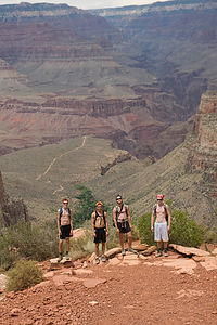 Beginning of Bright Angel TrailIt was a relatively quick 5 hour scenic drive from Bryce to the Grand Canyon through Navajo Territory.
We arrived in early afternoon and after a quick lunch got started on our hike. We went down the Bright Angel Trail. It has stops at 1.5, 3 and 5 miles down. If someone is willing to do an overnight at the bottom of the canyon, the trail continues all the way to the North Rim. We decided to stop at the 3 mile house (a little over 2,000 feet into the Canyon) partly because it was 104 degrees (but it’s OK, it’s a dry heat) and, at the Grand Canyon, what goes down must come up. And that “up” was starting to look worse and worse. The six mile round-trip was a very good distance.
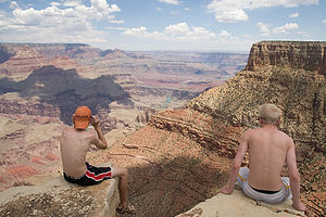 Overlook at Moran PointThere was a bit of a surprise on the way back up the trail. We turned a corner with our heads down, and almost stepped on a big horned sheep that was just sitting, chilling out and eating in the middle of the trail. Not wanting to frighten or anger an animal that could severely hurt us, and being only about ten feet away from it, we just held our ground and it allowed for Tommy and John to get some great pictures. Finally, we decided to take our chances and as we started to walk by, the sheep ran away.
It started raining right at the end of the hike so we headed to the General Store to pick up some dinner.
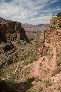 Winding TrailAfter dinner it was time to set up camp. Since we weren’t going to use the tent again, we decided to try and get creative. We grabbed out the hammocks and John climbed about ten feet up a tree and tied the first hammock. Then halfway between the top hammock and the ground the second one got tied, creating a set of hammock bunk beds. John was on top, Tommy in the middle, and Christian, Colin and I were beneath. (See picture)
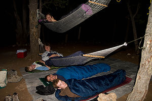 Sleeping ArrangementsThen it was time for John to try and get into his bed, which was even more entertaining for the group of people sitting around a fire in the campsite next to us, than it was for us. Roars of laughter emerged from them the first time Tommy fell out of his bed. It seems to be a pattern, everywhere we go, people stare. We’re like free entertainment. But eventually we all got settled in, and with the confidence that John would fall in the middle of the night and wake up everyone, while crushing Tommy, we went to sleep.
Day 12
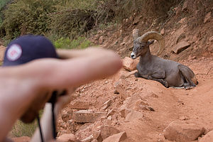 John Photographing BighornDay 12 was a bit of a “slow” day, which was nice, because we had a lot of time to ourselves to just kind of hang out, and weren’t rushed from one place to another to complete an agenda. We slept through the alarm and didn’t wake up until around 8:30. Surprisingly, neither Tommy nor John fell out of bed.
After breakfast we headed to the scenic drive to see all of the major “overlook points.” After we saw a few points we arrived at Moran Point. That was probably the best stop of the day because there was not only the same overlook platform as the other stops, but it allowed for us to hike out into the Canyon a little. We saw this plateauish looking cliff past the fenced overlook and John, Tommy, and I first climbed down and out onto it. Then Christian and Colin followed. It was probably the best view of the day, and was a great hike/climb.
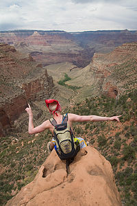 Christian Overlooking the CanyonShortly after that point we stopped at a picnic area to have our pretty consistent lunch of PB&J. We then headed back to the campsite to hang out for a little. When Tommy came back from running, we headed over to the showers (that makes 3 in 4 days) and paid our $2 for 8 minutes of water. A little shopping and then dinner took us to sunset, which we caught a shuttle to watch at Hopi Point.
When it got dark we set up our camp of five sleeping bags on a tarp (no creativity tonight), made a fire, and went to bed
- Jake
Description
Grand Canyon National Park, which is located in northern Arizona, is the nation's most popular national park, with over 5 million visitors a year. Everything about it is massive--it is 277 miles long, 1 mile deep, and an average of 10 miles across. The views from the rim are unparalleled and extend for as much as 200 miles on a clear day.
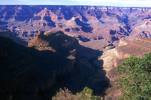 It's a Grand CanyonThe Grand Canyon is one of the most spectacular examples of erosion anywhere in the world, displaying 2 billion years of geological history on its canyon walls. For millions of years the waters of the Colorado River have carved this canyon, while runoff from the rim has cut hundreds of side canyons separated by buttes and mesas rising a thousand feet from the canyon floor. Its beauty defies description and a visit to the canyon is a humbling experience.
There are two ways to visit the park--the South and the North Rim. Although they are only 10 air miles apart from each other, it is a 215-mile drive between them. The South Rim, which is open all year, is by far the more popular section with more than 10 times the number of visitors than the North Rim, which is only open from May to late October. Advanced reservations are definitely recommended.
There are some wonderful day and overnight hikes in the park. However, because of the high demand for overnight permits, you should send in your application as early as 4 months in advance. Also, remember that summertime temperatures on the canyon floor often exceed 100 degrees, so pack plenty of water and hike in the early part of the day.
South Rim - Elevation 7000 feet
Because the South Rim is so crowded, it is switching over to a mass transit system in the next few years. A great way to approach the South Rim is from the east on the 26-mile long Desert View Drive which has numerous pull-offs to stop and enjoy the vistas.
Once you're there, a good way to see the sights is to hike the Rim Trail which runs 9 miles along the canyon's edge from Hermits Rest to Mather's Point, passing most of the attractions in Grand Canyon Village along the way.
The most popular hike of all in the park is the Bright Angel Trail which takes you zigzagging on switchbacks 7.7 miles and 4,420 feet down to the Colorado River. The views along the way are breathtaking. It takes about 4 hours to hike down and twice that to hike back, so it is not recommended as a day hike. A shortened version down to One-and-a-Half-Mile House, Three-Mile House, Indian Garden, or Plateau Point and back would be a more appropriate day hike choice
- ‹ previous
- 7 of 12
- next ›
Grand Canyon - South Rim location map
Javascript is required to view this map.

I don't know what to comment on first. Dad is just wondering if by chance Cabelas had tent stakes.
Jake, your narratives are getting better and better each day. The pictures are amazing (and sense of humor is reflected in many of them)!
You all look terrific and I'm so glad for all the shower updates.
Loved the way the bighorn stayed to pose for all those pics.
I can't tell you how hard I laughed while I was reading the narrative about the new sleeping arrangements and then when I saw the photo, I could definitely understand why the people in the next campsite found it so entertaining. Must you all sit and stand so close to the edge? I will say that the photos are amazing! Hugs and Kisses
I ditto Mary Claire's comment about Jake getting more creative and funny with his writing. We are enjoying the comments and the breathtaking pictures. Actually, a couple of them, I think I stopped breathing completely. Try not to sit on any cracked or crumbling boulders to get a better view where you have about 1/2 mile drop down. The " It's a Grand Canyon" picture is the first picture of the Grand Canyon I have ever seen, where I can honestly say it comes close to capturing the sheer magnitude of the view. So, hats off to whoever took that one and so aptly captioned it, John or Tommy! Love, Mrs. M
You guys are cracking me up! The pictures and the commentary are brilliant. I'm so glad you are having a good time. You will be talking about this adventure when you are old and gray (like us). Chris
Hi guys, I got weak in the knees looking at you standing or sitting right at the edge of the Canyons. Was the view really that much better than viewing it from a safer distance?
The "sleeping arrangement" was truly imaginative, but did Tommy not wonder if he would wind up as the filling of a sandwich!!!! Hope he got some sleep.
As always the pictures are just breathtaking. Keep having fun. Love Omi
We made our 1st cross country trip with our 3 children last summer and The Grand Canyon was one of the stops. Our kids would not even get close to the edge of the canyon, but of course my husband was right at the edge. All 3 kids, 12, 11, and 9 started crying. I, too get a funny feeling in my stomach just looking at the pictures of you guys at the edge. Great pictures that definitely do it justice...and great commentary. We are planning our next trip and I so very much appreciate all of the information on your website!
Thanks,
Linda from MD.
Hi Linda,
The boys are away at winter semester so I'll respond for them. I think the canyon's edge photos were designed as much to get a rise out of their parents, as well as for their photographic effect. I'll make sure they see your comment. Glad to hear that other cross country travelers are finding something to help them plan their trips on our site.
Safe travels,
Herb