- Home
- About
- Map
- Trips
- Bringing Boat West
- Migration West
- Solo Motorcycle Ride
- Final Family XC Trip
- Colorado Rockies
- Graduates' XC Trip
- Yosemite & Nevada
- Colorado & Utah
- Best of Utah
- Southern Loop
- Pacific Northwest
- Northern Loop
- Los Angeles to NYC
- East Coast Trips
- Martha's Vineyard
- 1 Week in Quebec
- Southeast Coast
- NH Backpacking
- Martha's Vineyard
- Canadian Maritimes
- Ocracoke Island
- Edisto Island
- First Landing '02
- Hunting Island '02
- Stowe in Winter
- Hunting Island '01
- Lake Placid
- Chesapeake
- Provincetown
- Hunting Island '00
- Acadia in Winter
- Boston Suburbs
- Niagara Falls
- First Landing '99
- Cape Hatteras
- West Coast Trips
- Burning Man
- Utah Off-Roading
- Maui
- Mojave 4WD Course
- Colorado River Rafting
- Bishop & Death Valley
- Kauai
- Yosemite Fall
- Utah Off-Road
- Lost Coast
- Yosemite Valley
- Arizona and New Mexico
- Pescadero & Capitola
- Bishop & Death Valley
- San Diego, Anza Borrego, Joshua Tree
- Carmel
- Death Valley in Fall
- Yosemite in the Fall
- Pacific Northwest
- Utah Off-Roading
- Southern CA Deserts
- Yosemite & Covid
- Lake Powell Covid
- Eastern Sierra & Covid
- Bishop & Death Valley
- Central & SE Oregon
- Mojave Road
- Eastern Sierra
- Trinity Alps
- Tuolumne Meadows
- Lake Powell Boating
- Eastern Sierra
- Yosemite Winter
- Hawaii
- 4WD Eastern Sierra
- 4WD Death Valley +
- Southern CA Deserts
- Christmas in Tahoe
- Yosemite & Pinnacles
- Totality
- Yosemite & Sierra
- Yosemite Christmas
- Yosemite, San Diego
- Yosemite & North CA
- Seattle to Sierra
- Southwest Deserts
- Yosemite & Sierra
- Pacific Northwest
- Yosemite & South CA
- Pacific Northwest
- Northern California
- Southern Alaska
- Vancouver Island
- International Trips
- Index
- Tips
- Books
- Photos/Videos
- Search
- Contact
Grand Teton National Park, WY
Tuesday, July 7, 2009 - 7:30am by Tommy
109 miles and 2.5 hours from our last stop - 2 night stay
Travelogue
Day 7
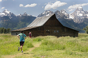 Moulton BarnWas our first of two days at Grand Tetons. It’s an amazing park. It is so close to Yellowstone, but much different and smaller so it’s not quite as overwhelming.
We arrived late morning and choose to check out some of the viewpoints instead of setting up camp right away. We headed to the Oxbow Bend, Jenny Lake, and Cathedral Group Turnout along with a few others.
We stopped at the Cottonwood creek picnic area for some lunch, and then headed right down to the river to check it out. It turned out to be some great swimming. It was very cold, but still fun. We body surfed/floated down the rapids for most of the afternoon.
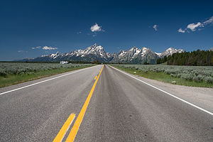 Road up to TetonsWhen we dried off and warmed up we headed to where Ansel Adams took the famous “Snake River and the Tetons” picture so Tommy and John could get their own versions.
After picture taking we set up camp in the Gros Ventre campground, made dinner, and went to the Snake River Overlook to watch the sunset.
When it got dark we went into Jackson to do some food shopping. John led us on an “interesting” way home, and by the time we got back to the tent it was really late.
Day 8
We woke up with the sun again so that we could head over to the very crowded, very popular, very nice Jenny Lake Campground. We picked out our spot and self-registered.
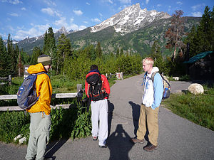 Setting Out From the CarAfter camp was set up we drove over to the Jenny Lake Ferry so we could get over to the start of our hike for the day: Cascade Canyon. It was absolutely stunning. It’s hard to say which was better: Mt. Washburn (Yellowstone hike) or Cascade Canyon because the two were so different. Mt. Washburn was simply a hike up the mountain and the views just kept getting better and better the higher you went. Cascade Canyon was a trail through a canyon in Teton park and followed the Cascade River.
We got to the 9 mile fork in the trail and instead of heading the extra 5 miles to Lake Solitude, a threat of thunderstorms made us stop there so we weren’t stuck atop a mountain during the monsoon.
It never rained.
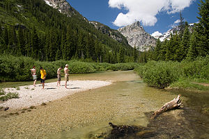 Our Little IslandBut we still have no regrets with our decision to stop where we did. Instead we took our time on the hike back and stopped to spend some time by the river. We saw a little rock island in the middle of a relatively wide section and left out gear and our shoes on the shore to wade through the glacial waters to the island. We estimated that the water was about 40 degrees, and then decided to go swimming. The water wasn’t deep enough and the current wasn’t strong enough to ride the rapids down like the Cottonwood Creek the day before. But the water temperature made it so we could only stay in for about 10 seconds at a time. Through the freezing water and the strange looks we got from passing people on the trail, it was a great time.
The only negative part of the trail was how crowded it gets in the beginning. One of the biggest tourist attractions, Inspiration Point, is only a mile down the trail. So basically every grandparent, parent, child and infant who enters the park, goes to see it. Luckily for us we got one of the first couple ferry’s across the lake in the morning and the trail was empty when we started the hike. But when we headed back down the trail, our last mile (the mile between the beginning and Inspiration Point) was so packed that we couldn’t wait to get to the end.
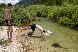 John Diving Into Glacial RunoffNow remember from the Badlands post, we have no tent stakes. So we arrived back at our campsite only to find no tent. It had been blown about forty feet from its original spot and was flat as a pancake. We picked it up only to realize that it broke. It’s very difficult to describe how it broke, but long explanation short, our tent normally has four main poles. When we set it up it only has three now. But morale remained high and we bought some stakes.
We went back to Jackson to walk around a little bit and eat dinner. We told some strange lady who runs an art gallery in Jackson that we were basically broke and asked where we should eat. She recommended this “world famous” burger place, “Billy’s Famous Burgers.” So we went. Now I don’t know if it’s actually world famous, but it was delicious. And we met some sweet vagabond who hitchhikes his way around the country and plays the accordion.
We were then going to hit up a biker bar for some free music and go crusin’ for chicks, but we went back to our tent, made a fire, and I gave the group an astronomy lesson. They can all thank Mr. Cimmino for my vast knowledge in the field.
- Jake
Description
Grand Tetons National Park's 485 square miles encompasses the Jackson Hole Valley and the Teton Mountain Range which towers 7,000 feet above the valley floor. Although the park is best known for its three most prominent peaks, the Grand, Middle, and South Tetons, there are other equally spectacular mountains in the Teton Range, 12 of which are higher than 12,000 feet.
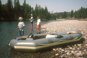 Herb and boys fishing for trout on the Snake RiverAt the base of the mountains lies a string of 7 glacier-carved lakes, fed by mountain streams. Beyond the lakes lies the beautiful Jackson Hole Valley with 50 miles of the Snake River winding through it. The wetlands along the braided sections of the river provide a rich habitat for wildlife, such as moose, elk, pronghorn, bison, black bear, deer, bald eagles, blue herons, river otters, and even pelicans.
Most of the major observation points and attractions can be seen from the Teton Park and Jenny Lake Loop Roads, which meander 25 miles along the Jackson Hole Valley from Moran Junction to Moose Junction, providing spectacular views of the Tetons along the way.
The 4-mile paved Signal Mountain Summit Road climbs 1,000 feet to the summit of Signal Mountain, where there is a tremendous 360 degree panoramic view of the Tetons and Valley below. A mile before the summit is the Jackson Lake Overlook, from which William Henry Jackson took his famous photographs of the Grand Tetons. Unfortunately, the Signal Mountain Summit Road is so narrow and windy that RV's are prohibited.
The one-way scenic drive on the Jenny Lake road along the shores of the lake brings you to one of the busiest and most popular sports in the park. A very popular hike from this area is the Cascade Canyon Trail to Hidden Falls and Inspiration Point. To get to the trailhead you can either walk the 2.5 miles around the southern end of the lake or take the shuttle boat, which runs every ½ hour, across to the West Shore Boat Dock. From there, the fairly strenuous trail climbs 420 feet over one mile. At the ½ mile point is Hidden Falls, one of the most beautiful spots in the park. A ½ mile further is the aptly named Inspiration Point with a spectacular view of the lake, surrounding mountains, and the valley. If you wish to continue further, the trail levels out after this point and the views get even better. On the way back, you have the same choice of hiking the lakeshore or taking the shuttle boat.
- Lolo
- ‹ previous
- 5 of 12
- next ›
Grand Teton National Park location map in "high definition"
Javascript is required to view this map.

Sounds like the weather is getting better since you've taken some plunges in the water. Uncle John said today that July and August are the rainy months out west and that at times it can be very bad. But I guess you guys have already found that out! The long post was a treat to find when I got home from work today:)
Can't believe "someone" forgot to bring tent stakes along. I suppose that is part of the adventure?
No run ins with bison? (Probably not brushing your teeth has kept them away...)
Can't wait to see the Ansel Adams competition photos.
Thanks for all the great end of the day reading and photos. VERY impressive!
Who is the photographer? The pictures and narratives are terrific-great job! It sounds like you are getting through the tent troubles and having a great experience. I am jealous. Keep on keeping on.
Tom, I like the composition of the Moulton Barn photo. It was a great idea to personalize it with Colin running in the foreground. Keep up the good work!
Tommy, your pictures are just great. The apple does not fall far from the tree! Next time you will surely take stakes for the tent! I can just imagine you, finding your diggings reduced to a pancake. Well, you survived and I hope you keep having a good time and improvement in the weather. Love and good luck. Omi