- Home
- About
- Map
- Trips
- Bringing Boat West
- Migration West
- Solo Motorcycle Ride
- Final Family XC Trip
- Colorado Rockies
- Graduates' XC Trip
- Yosemite & Nevada
- Colorado & Utah
- Best of Utah
- Southern Loop
- Pacific Northwest
- Northern Loop
- Los Angeles to NYC
- East Coast Trips
- Martha's Vineyard
- 1 Week in Quebec
- Southeast Coast
- NH Backpacking
- Martha's Vineyard
- Canadian Maritimes
- Ocracoke Island
- Edisto Island
- First Landing '02
- Hunting Island '02
- Stowe in Winter
- Hunting Island '01
- Lake Placid
- Chesapeake
- Provincetown
- Hunting Island '00
- Acadia in Winter
- Boston Suburbs
- Niagara Falls
- First Landing '99
- Cape Hatteras
- West Coast Trips
- Burning Man
- Utah Off-Roading
- Maui
- Mojave 4WD Course
- Colorado River Rafting
- Bishop & Death Valley
- Kauai
- Yosemite Fall
- Utah Off-Road
- Lost Coast
- Yosemite Valley
- Arizona and New Mexico
- Pescadero & Capitola
- Bishop & Death Valley
- San Diego, Anza Borrego, Joshua Tree
- Carmel
- Death Valley in Fall
- Yosemite in the Fall
- Pacific Northwest
- Utah Off-Roading
- Southern CA Deserts
- Yosemite & Covid
- Lake Powell Covid
- Eastern Sierra & Covid
- Bishop & Death Valley
- Central & SE Oregon
- Mojave Road
- Eastern Sierra
- Trinity Alps
- Tuolumne Meadows
- Lake Powell Boating
- Eastern Sierra
- Yosemite Winter
- Hawaii
- 4WD Eastern Sierra
- 4WD Death Valley +
- Southern CA Deserts
- Christmas in Tahoe
- Yosemite & Pinnacles
- Totality
- Yosemite & Sierra
- Yosemite Christmas
- Yosemite, San Diego
- Yosemite & North CA
- Seattle to Sierra
- Southwest Deserts
- Yosemite & Sierra
- Pacific Northwest
- Yosemite & South CA
- Pacific Northwest
- Northern California
- Southern Alaska
- Vancouver Island
- International Trips
- Index
- Tips
- Books
- Photos/Videos
- Search
- Contact
Sunset Bay State Park, OR
Tuesday, September 17, 2013 - 7:00pm by Lolo
156 miles and 3.5 hours from our last stop - 2 night stay
Travelogue
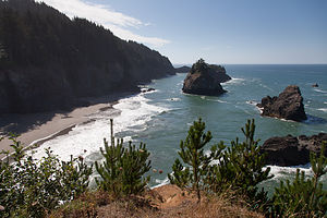 Samuel H. Boardman State Scenic Corridor Ocean ViewOregon is a state that we have neglected in our past travels – it was just too far to include in a 3 ½-week out and back trip from New Jersey. However, now that Tommy is living in Seattle, we will have many more opportunities to explore this beautiful state. On our last trip 2 months back, we visited Bend and Crater Lake, but this time we were going to drive the coastal route – all 363 breathtaking miles of it.
One great thing we have discovered about the Northern California and Oregon coast is that so much of it is publicly accessible through the state park systems. Along the Oregon Coast alone there are about 90 state parks, recreational areas, scenic viewpoints, etc., 18 of which have campgrounds. That is one for every four miles of road – not something you would find on the East Coast.
 Arch RockKnowing the multitude of camping choices beforehand, I did my research and reserved Sunset Bay State Park, in Coos Bay (about 120 miles north of the California border) for two nights. We find that two nights is the minimum to really get to experience a place. There were so many good parks to choose from, but this one kept coming up in the guidebooks as pretty spectacular.
One of the most beautiful stretches of the coastline is the 12-mile Samuel H. Boardman State Scenic Corridor, a forested linear park with tremendous views of rugged cliffs, secluded cove beaches, and forested sea stacks. The park was named for the first Oregon Parks superintendent, and a monument in his honor told how it was mostly due to his foresight and efforts that so much of the Oregon coastline has been set aside for current and future generations to enjoy.
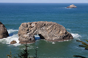
We stopped at the viewpoint for one more of the Corridor’s gems, Arch Rock, an offshore monolith carved into an arch by the relentless waves of the sea.
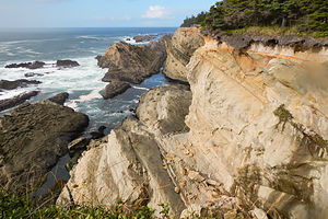 Shore Acres State Park Ocean ViewThere were so many beautiful viewpoints and parks along the Oregon Coast Highway, but we would never get to our campground if we stopped at all of them. You could literally spend days exploring this route. We would have to be discriminating in our choices.
Sunset Bay State Park certainly did not disappoint. The campground was located just across the road from a beautiful cove, surrounded by sandstone cliffs. I could already picture that evening's cocktail hour watching the sun dip below the horizon in this dramatic setting.
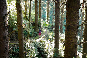 Lolo Running Through JungleBeing a bit too early for cocktailing, we decided to go for a run on the hiking trails that connect Sunset Bay with its sister parks, Shore Acres and Cape Arago. We figured we would take a nice 5-mile run first, and then get back to the campground to shower and prepare for sunset on the beach. We took a camera along on our run in anticipation of some pretty awesome views.
According to the trail map, the trail ran along the top of the bluffs through Shore Acres State Park (in 2 miles) and onto Cape Arago State Park (in 4 miles). Unfortunately, we probably didn’t have time to do the entire 8-mile run and still get back in time for sunset. We decided to just head out and play it by ear.
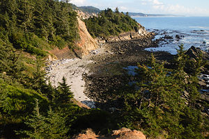 Cape Arago ViewpointThe trail left Sunset Beach and immediately climbed to the top of the bluffs, where the views were so good that we kept stopping to take pictures. At this rate, I figured we weren’t going to get in too much of a run. At about ¼ mile in, we must have made a wrong turn, because we wound up on a rocky cove beach that dead ended. A bit confused as to how we had missed the trail, we retraced our steps back up from the cove and continued on what we now thought to be the correct trail.
When we reached Shore Acres State Park, we began the negotiating phase of the run. I wanted to continue on and see Cape Arago, but Herb, seeing his sunset cocktail hour slipping away, wanted to turn back. I assured him that we could have it all, both the full run and making it back in time for sunset.
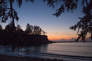 1st Night at Sunset Bay BeachA bit further on, we came to a trail junction and decided to follow the white chalked arrows pointing towards the left. These arrows must obviously be pointing us in the correct way, we thought. As we began an extremely steep descent through a jungle, followed by an equally steep ascent, we began questioning whether we were actually on the right trail. This was supposed to be a pleasant family stroll, not an eco-challenge. This ridiculous up and down went on for 2 ¼ miles. I admit I was getting very concerned that we might be lost, and it didn’t help that the thick jungle-like flora was making it very dark in here.
Finally, we came out on the road near South Cove in Cape Arago. We were both a bit cranky at this point, totally focused on figuring out who was to blame for this very dysfunctional trail run. We had already run 6 miles, so rather than attempt to find the trail that we should have taken to get here, we decided to take the most direct route back, which meant running on the road back to Sunset Bay State Park. We barely stopped to see the sea lions barking on Shell Island just offshore and continued on with the thought of returning here another day—by car.
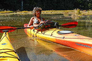 Lolo in her Kayak at the South Slough National EstuaryI couldn’t believe how quickly we got from Cape Arago to Sunset Bay by road compared to what we had gone through in the other direction. Still, I didn’t regret it. It was an adventure, and we did get a much better workout in than originally planned.
Plus, we didn’t totally miss the sunset. With no time to shower, we hurried down to the beach just in time to chug down a glass of wine and take some photos. We would have to plan better for the next night.
The next day was our kayaking day, our first on the West Coast. When we moved the motorhome out west in June, we brought our kayaks, but had not as yet had the opportunity to use them. Now it was time for their maiden voyage into the Pacific—well not exactly the Pacific, but an estuary that connected to it.
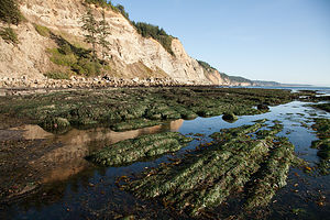 South Cove Beach at Cape AragoWhen researching kayaking in the Coos Bay area, everything seemed to point to the South Slough National Estuary as a premier kayaking destination. We had also read that it was important to time our trip with the tides, in order to paddle the incoming tide south from the ocean and the outgoing tide back north, as the water receded back to the ocean. Also, if you stayed south too long, you could run out of water and get caught up in the mudflats. Fortunately for us, the tides allowed for a late morning launch and a mid-afternoon return.
We launched the kayaks at the Port of Coos Bay Industrial Annex Landing just south of the bridge and the fishing boat traffic. The water was extremely calm and we were able to leisurely paddle along with the current enjoying the wildlife, especially the herons and egrets.
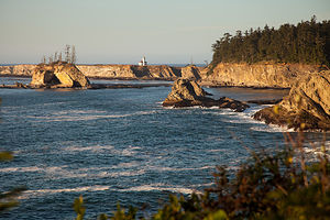 Cape Arago LighthouseSince time and the tide were on our side, we decided to paddle into freshwater Elliot Creek where we ate out lunch. About this time, as always happens to us when kayaking, the wind began to pickup from the north, meaning that we would have to battle against it the whole way back, once again turning a leisurely event into a strenuous workout—just like yesterday’s run. The wind also made the water much rougher, very different from the glassy surface we cruised down in the morning.
After a total of 9 miles of paddling, we made it back to the boat launch, which I was very happy to see.
Back at the campground, we decided to drive the car to Shore Acre and Cape Arago State Parks to visit the places we didn’t have time to enjoy yesterday.
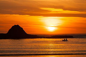 Boaters at Sunset BayOur first stop was the Botanical Gardens in Shore Acre State Park. This park was once the estate of a timber baron. Although the manor house is long gone, the gardener’s cottage and 5 acres of formal gardens remain for visitors to enjoy. We arrived too late for the visitor center, but we were able to enjoy a stroll through both an English garden and a Japanese garden with a lily pond.
Our next stop was the Simpson Reef Wildlife Viewpoint to watch and listen to the seals and sea lions that live on Shell Island, a short distance offshore. The day before on our run, I would occasionally hear the barking of seals and had no idea where the sound was coming from. Now we had discovered its source, and there was a whole colony of them.
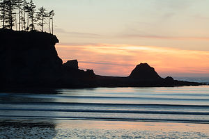 Sunset Bay Beach AfterglowWhen we got to the end of the road in Cape Arago, we hiked down the South Cove Trail to the tide pools. Once again, the tides were in our favor, and we were able to see many starfish and anemones.
Satisfied with having seen what Shore Acre and Cape Arago State Parks had to offer, we headed back to Sunset Bay to enjoy a more leisurely sunset cocktail hour. It reminded me a bit of our sunset viewing on Caspar Beach in Mendocino, California on our earlier trip.
One thing the West Coast definitely has over the East is dramatic sunsets over the water. The East Coast does have its sunrises, but I sleep rather than cocktail through those—probably a good thing.
If this was just a taste of what the Oregon Coast has to offer, we would definitely be back to enjoy some of those 17 other state park campgrounds.
Description
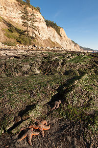 Starfish at South Cove Beach, Cape AragoSunset Bay State Park, in Coos Bay, Oregon, is located in one of the most scenic areas on the Oregon Coast. Its campground is located just across the road from a beautiful cove surrounded by sandstone cliffs, an excellent place to watch a dramatic sunset. A network of hiking trails connects Sunset Bay with nearby Shore Acres and Cape Arago State Parks, which sit atop rugged sandstone cliffs and headlands.
Shore Acres State Park, once the estate of a timber baron, has a beautiful formal English garden and a Japanese garden with a lily pond.
Cape Arago State Park is located at the end of the Cape Arago Highway, just 2.5 miles south of Sunset Bay, is a scenic headland that juts out into the ocean. There are two main trails here. The North CoveTrail leads to a view of an off-shore colony of seals and sea lions on Shell Island. The South Cove Trail leads down to a sandy beach and tide pools.
- ‹ previous
- 3 of 19
- next ›
Sunset Bay State Park location map in "high definition"
Javascript is required to view this map.
