- Home
- About
- Map
- Trips
- Bringing Boat West
- Migration West
- Solo Motorcycle Ride
- Final Family XC Trip
- Colorado Rockies
- Graduates' XC Trip
- Yosemite & Nevada
- Colorado & Utah
- Best of Utah
- Southern Loop
- Pacific Northwest
- Northern Loop
- Los Angeles to NYC
- East Coast Trips
- Martha's Vineyard
- 1 Week in Quebec
- Southeast Coast
- NH Backpacking
- Martha's Vineyard
- Canadian Maritimes
- Ocracoke Island
- Edisto Island
- First Landing '02
- Hunting Island '02
- Stowe in Winter
- Hunting Island '01
- Lake Placid
- Chesapeake
- Provincetown
- Hunting Island '00
- Acadia in Winter
- Boston Suburbs
- Niagara Falls
- First Landing '99
- Cape Hatteras
- West Coast Trips
- Burning Man
- Utah Off-Roading
- Maui
- Mojave 4WD Course
- Colorado River Rafting
- Bishop & Death Valley
- Kauai
- Yosemite Fall
- Utah Off-Road
- Lost Coast
- Yosemite Valley
- Arizona and New Mexico
- Pescadero & Capitola
- Bishop & Death Valley
- San Diego, Anza Borrego, Joshua Tree
- Carmel
- Death Valley in Fall
- Yosemite in the Fall
- Pacific Northwest
- Utah Off-Roading
- Southern CA Deserts
- Yosemite & Covid
- Lake Powell Covid
- Eastern Sierra & Covid
- Bishop & Death Valley
- Central & SE Oregon
- Mojave Road
- Eastern Sierra
- Trinity Alps
- Tuolumne Meadows
- Lake Powell Boating
- Eastern Sierra
- Yosemite Winter
- Hawaii
- 4WD Eastern Sierra
- 4WD Death Valley +
- Southern CA Deserts
- Christmas in Tahoe
- Yosemite & Pinnacles
- Totality
- Yosemite & Sierra
- Yosemite Christmas
- Yosemite, San Diego
- Yosemite & North CA
- Seattle to Sierra
- Southwest Deserts
- Yosemite & Sierra
- Pacific Northwest
- Yosemite & South CA
- Pacific Northwest
- Northern California
- Southern Alaska
- Vancouver Island
- International Trips
- Index
- Tips
- Books
- Photos/Videos
- Search
- Contact
Sequoia and Kings Canyon National Parks, CA
Tuesday, May 22, 2012 - 2:15pm by Lolo
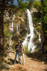 Mon and Dad by Waterfall - TJGWell, it was time to leave Kings Canyon, but before doing so we had one last stop to make. Yesterday, after we finished our Mist Falls hike, we had totally forgotten our plan to stop at Muir Rock afterwards. Being great admirers of John Muir and all he has done to help create the National Park System, we thought it worth the drive back down to Roads End to pay him some well-deserved homage.
400 miles and 7 hours from our last stop - 3 night stay
Travelogue
I had spent quite a bit of time researching Sequoia and Kings Canyon and determined that the best approach would be to spend one night at the John Muir Lodge, just inside the Big Stump Entrance to Kings Canyon, from which to explore the Sequoia section, and then move on to the Cedar Grove Lodge at the end of Kings Canyon for two nights to allow us to do a long day hike into the canyon.
The following is a description of how we spent a very wonderful three and a half days in Sequoia and Kings Canyon.
Day 1 – John Muir Lodge, Panoramic Point, and General Grant Tree
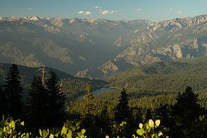 View from Panoramic Point - TJGThe drive from the airport to the John Muir Lodge took us about five hours, bringing us past the beautiful San Luis Reservoir and through the rich agricultural landscape of central California.
Although it was already 6:30 when we arrived, and probably time to think about feeding ourselves, we decided instead to take a quick run up to Panoramic Point, which the guide books described as having a breathtaking view of Kings Canyon. Herb was a bit skeptical about my plan and accused me once more of trying to “pack 10 pounds into a 5 pound bag.” After all, he had driven the whole way and wanted to just relax and have a beer. As usual, he lost the argument and we set off up the steep, winding 2.3 mile road to the Point. This was one time I was glad that we didn’t have the RV, because I’m not sure if it would have made it up this road; in fact, I don’t think it was even allowed. The boys decided they needed the exercise and hill training, so they chose to run (or more correctly race) to the top.
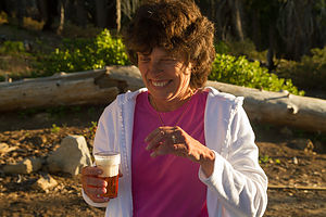 Lolo enjoying her IPA - TJGOnce on top, we took out our movie camera and awaited the boys’ arrival. Unfortunately, I wasn’t ready with the camera when Andrew appeared a few yards ahead of Tommy to declare victory in the grueling uphill race. I was so mad that I missed what would have been really good footage that I asked them to repeat the final stretch so I could get it on film. Andrew was so exhausted from his actual victory that Tommy cruised past him in the reenactment, immortalizing his victory at Panoramic Point. Andrew cried foul, but the tape is the tape.
The view of Kings Canyon and Hume Lake below was well worth the trip, and I rewarded Herb’s flexibility with a cold IPA (or two) from the cooler. At this point we had two choices: rush back down to have dinner before the only restaurant in the village closed at 8:00, or stay to watch the lighting change over the canyon as sunset approached. This time, we unanimously voted to stay, and I went and got what remained of the delicious sandwiches Celeste and her mother had made out of the trunk – definitely the right decision.
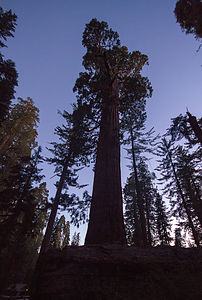 General Grant tree at dusk - TJGAlthough it was now 11:00 east coast time and we had been up since 3:00 this morning, we were on an irresponsible roll and decided to squeeze another 5 pounds into that already overstuffed 5 pound bag and hurry over to the General Grant tree while there was still a wee bit of daylight. So, it was back down the narrow, windy hill, past the John Muir Lodge where we were staying, and over to the General Grant Grove where we practically sprinted the ½-mile trail to find the Big Fella while we could still see it. As we gazed in awe as the 3rd largest living tree in the world faded into darkness, Andrew whispered, “It’s glowing…like an angel,” and in our collective delirium from lack of sleep (and a few IPAs) we burst into laughter. From that point on, “it’s like an angel” became our metaphor for any sight that impressed us.
Finally, at what was now midnight east coast time and 21 hours since we had awoken this morning, we decided to call it a day and return to our room at the John Muir Lodge. The lodge was actually quite cozy with that rustic national park feel that I have come to love, and a perfect base camp from which to explore both Sequoia and Kings Canyon. It would have been nice to have been able to spend a little time just relaxing in the rocking chairs on the porch, but alas that was not to be.
Day 2 – Sequoias and more sequoias, Moro Rock, Crescent Meadow, Hume Lake, Kings Canyon Scenic Byway, and Cedar Grove Lodge
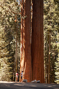 Siamese twin Sequoia treesMuch of Sequoia and Kings Canyon is inaccessible by road. There are two major roads in the park and they are shaped sort of like a backwards 7 with Grant Grove Village, where the John Muir Lodge is located, at the vertex. South of Grant Grove is the Generals Highway which takes you deep into Sequoia country with such notable stops as Giant Forest and Moro Rock (about a 2 hour drive from Grant Grove Village). North and then east of Grant Grove is the spectacular Kings Canyon Scenic Byway, a 31-mile rollercoaster road, which descends deep into the canyon, connecting Grant Grove and Cedar Grove. There are also a few additional out and back side roads off the two major roads.
Today, we would do them both: the Generals Highway to Giant Forest for the major part of the day and then later that afternoon the Kings Canyon Scenic Byway to get to our accommodations for the night at Cedar Grove. Since we only had about eight hours to explore the Sequoia part of the park, I had to be somewhat selective in our choice of stops. In an attempt to get an overall representative sampling of this amazing park, I chose a meadow, a rock, and, of course, lots of giant trees.
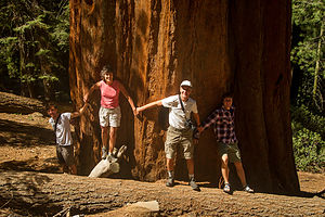 Sequoia Tree HuggersOur first stop along the Generals Highway was a pullout in the midst of a beautiful sequoia redwoods forest. I found my favorite sequoia tree here (actually it was two Siamese twin trees), because it wasn’t fenced in like a zoo exhibit or surrounded by throngs of people. It was just there for us to marvel at – “it was like an angel.” As we were doing this tree photographic justice, a gentleman from Texas suggested we do what his Aunt Clovis always had them do – hold hands and try to encircle the tree, kind of like group tree hugging. With arms fully outstretched, we still were only able to make it about halfway around – and this was not even one of the park’s designated giants, but just some old random tree along the highway.
Then it was on to the Lodgepole Visitor Center where we watched an interesting film about bears in the park. Once we were back on the Generals Highway, there was an anguished cry from the backseat as Andrew realized that he left his very expensive camera on the seat next to him in the dark Visitor Center theater. We frantically raced back to the Visitor Center and were delighted to find that a kind and honest fellow traveler had turned it in to the ranger at the desk. Crisis averted, we continued on down the Generals Highway.
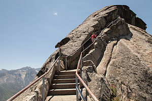 Moro Rock ApproachWe passed the parking lot for the landmark General Sherman Tree (we would hit that on the way back) and continued on to the turn off onto Crescent Meadow Road to get to both the Crescent Meadow and Moro Rock hikes.
We tend to be partial to rocks and expansive views, so the hike to the top of Moro Rock was a highlight. The trail was fun – 400 steps carved into the side of the dome. As promised, the 360 degree view of the surrounding snow-capped mountains of the Great Western Divide from the top was breathtaking.
The road to Crescent Meadow was awesome, with giant sequoias lining both sides of the road. There was even one spot where you could drive through a tunnel cut out of a fallen one, appropriately named Tunnel Log. However, since there was a backlog (no pun intended) of cars hogging it, we took the bypass road around it, hoping to get our chance on the way back out.
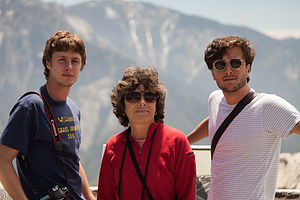 Lolo and Boys at Summit of Moro RockThis was bear country, so the parking lot for the Crescent Meadow hike had signs warning visitors to not leave any food in their cars, but to store them in one of the nearby bear boxes. Not wanting to risk the unlikely but unpleasant possibility of having the trunk lid of our rental car ripped off, we spent a bit of time emptying the very ample contents of our trunk into a bear box before hitting the trail.
The hike was an absolutely lovely stroll through a meadow surrounded by firs and giant sequoias. Here, one could get up close and personal with the trees, and even in some cases, enter their fire-hollowed trunks – much more intimate than viewing the more famous landmark trees from behind a fence. The lack of other hikers on the trail made the experience even more peaceful and serene.
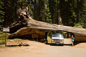 Tunnel Log - TJGAmidst all the natural wonders of the meadow, we came across was an interesting man-made landmark – a tiny cabin built from a fallen, fire-hollowed sequoia, complete with stone chimney. Named Tharp’s Log, it was built back in the 1860s by a cattle rancher named Hale Tharp. He was the first non-Native American settler to live in the area. John Muir, who was a frequent visitor to the area, referred to it as a “noble den.” It must have been quite peaceful living here in solitude amongst these silent giants.
After our hike, we collected our goodies from the bear boxes and made a picnic lunch before returning to the Generals Highway to begin retracing out route north. This time, we did get a chance to drive through Tunnel Log, and I must confess we jammed it up to with our need to get out and take a picture.
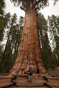 Tommy with General Sherman TreeOur final stop in Sequoia, and by far the biggest (both literally and figuratively) attraction in the park, was the General Sherman Tree, the largest living tree on earth--a distinction based on volume, as it is neither the tallest nor the widest tree, but the heftiest, producing the equivalent of another 60-foot tree each year. After our more intimate experiences with giant sequoias—the Aunt Clovis tree that we had hugged and the ones that had invited us in to gaze up through their hollowed-out trunks to the sky—the crowds and fenced in trees here really turned us off. After a brief paying of our respects to this truly awesome tree and the obligatory photo in front of it, we hit the road once again to head towards the Kings Canyon section of the park.
Rather than retrace our route back through Grant Grove, we took a shortcut towards Hume Lake to provide a little variety. Hume Lake was the lake we had gazed down on from Panoramic Point the first night, so we thought it would be nice to see it from eye level. The road was pretty winding and twisty, but nothing our little Toyota rental car couldn’t handle. The lake and sandy beach were too tempting to pass up, so the boys stripped down to their boxers and jumped in.
We were getting pretty hungry by now, and the National Park Map showed only one possibility along the way – the Kings Canyon Lodge about 12 miles further along the Kings Canyon Scenic Byway. I liked the sound of it. I love National Park lodges with their cozy décor, high beamed ceilings, and stone fireplaces. I only hoped we were dressed nicely enough. After all, the boys were still sitting on towels in their wet boxers in the back seat. Anticipation rose as the GPS showed us inching our way closer and closer to the Lodge. We had been living on sandwiches for the past two days, so the thought of a hearty meal in a lovely setting was very appealing.
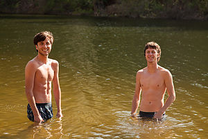 Boys in Hume LakeAs we pulled into the parking lot for Kings Canyon Lodge, a jaw-dropping silence fell over us. Rather than the grand park lodge I had visualized perched over an equally majestic canyon, we were greeted by a vision much less appealing: a few dilapidated cabins, a small office building, and a set of antique gas pumps posted with the very inviting welcome: “No Pictures Without Permission.” Despite my disappointment, I put on a brave face, turned to the others and said, “Okay, let’s go get something to eat.” I felt like Clark Griswold pulling into Wally World.
I think I started things off on the wrong foot when we walked into what I thought was the office and asked the somewhat surly-looking gentleman behind the counter where the restaurant was.
“You’re looking at it,” was his rather curt response.
Oh boy. I looked up and noticed a menu board behind him. “I’ll be right back,” I told him as I motioned the boys to follow me back outside. After a brief conference, and the realization that this was the only place to eat in about 25 miles, we collected Herb and bravely went back to give it a try. The owner looked on disinterestedly as we scanned the menu board. I have this tendency of asking too many questions, which drives the boys crazy, so they cringed when I asked the nice gentleman if the Santa Fe sandwich had chicken on it, especially since it clearly did not mention chicken as one of the ingredients listed on the board. I just really wanted it to have chicken on it.
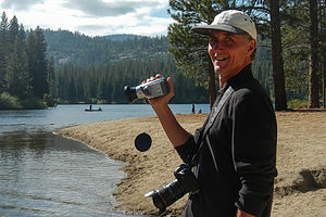 Herb the Videographer - LEG“We don’t have chicken.”
Another brief conference. “Okay. “We’ll have four cheeseburgers then.” I then continued with, “Do we eat at the counter or can we eat outside on the picnic table.”
“Doesn’t matter to me.”
This guy was a real gem. Not wanting to be in this man’s presence any longer than necessary, we went outside to await our burgers. I headed towards a small building behind the “restaurant” that was the restroom, but quickly exited when I saw how disgusting it was – and being a camper, I have a pretty high tolerance for bathrooms.
In a reasonable amount of time, our friend brought out our food and plopped it down in front of us without a word. If we weren’t so hungry, I think we would have been afraid to take a bite, but we did and it was actually pretty good.
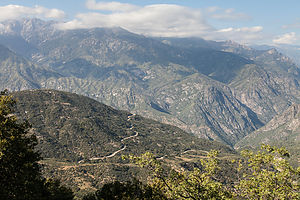 Road to Kings CanyonWhen we were done, my cowardly men voted to send me back in to pay. By now two of his equally surly friends had joined him at the counter. I quietly handed him the check and my credit card, and he brought our hospitable dining experience to a close with:
“You wanna add a tip to that?
“Not particularly,” I thought, but feeling quite intimidated, I tipped quite generously and then got out of their as fast as I could.
Just out of curiosity, when we had internet coverage later, I looked for reviews of the Kings Canyon Lodge and found that I was not the only one that had had a bizarre experience. The funny part was the gentleman that I dealt with was actually the charmer of the family. His wife actually cursed at a family and grabbed their food back because they had their own juice boxes at the picnic table. Sounds like we got off easy.
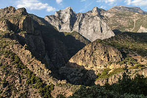 Kings Canyon Road ViewpointThe rest of the drive into Kings Canyon was spectacular. While the drama of the drive was the steep granite walls and the sheer drop offs into the canyon, one of my favorite sights were the yucca plants whose feathery fronds sprang incongruously from the near vertical canyon walls, where you would think no plant could take hold.
We intentionally passed the turnoff for the Cedar Grove Lodge and drove the remaining 5 miles to Roads End, where the Scenic Byway ends and pure wilderness begins. There was still a bit of daylight left, although not much, so we thought we would get a preview of what was in store for us tomorrow before checking into our motel for the night. We found the trailheads for tomorrow’s two hikes: Mist Falls and Zumwalt Meadow and then took the short, and very rewarding, hike to the Roaring River Falls.
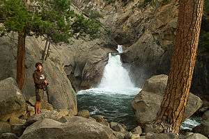 Andrew by Roaring River Falls - TJGIt was getting late, and we were tired from our long day of exploring so many wonderful and diverse sights, so we headed back to the Cedar Grove Lodge. As usual, I ran ahead to check in, while Herb organized stuff to bring in. When I got to the office, I became quite concerned to find that it was dark and closed up for the night. I pressed my nose against the glass, but saw no one inside. What were we going to do? We were out at the end of nowhere with the nearest civilization back 30 miles at the (dare I say it) Kings Canyon Lodge. Seeing lights on in the store/restaurant next to the office, I ran there and began tugging on the door, only to find that it too was locked for the night. Noticing a young man mopping the floor inside, I began pounding on the glass window and waving my arms to get his attention. He looked frightened. “What are you doing?’ Herb asked as he handed me an envelope with room keys left for us in the box by the office door. Oops.
A short while later, while sitting on the deck of the lodge overlooking the river, a frantic woman came running up to us with a look of total panic on her face – very similar to the one I had been sporting about an hour ago – and asked us if we knew how she could find someone to check in. Feeling her pain, we calmly told her to look in the box for an envelope with her name on it. She was so relieved and grateful I thought she was going to cry. They really need a more obvious system for late arrivals.
The next morning, however, all was forgiven when we wandered down to the store and found that they served Starbuck’s coffee.
Day 3 – Mist Fall Hike, Zumwalt Meadow Hike, and Cedar Grove Lodge
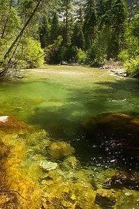 Bubbs Creek - TJGThe next morning we set out early for our hike to Mist Falls, one of the most popular hikes in the park. We drove the 5 ½ miles back down to Road’s End to get to the trailhead. Since most of Kings Canyon is inaccessible by car, this is the starting point for the hundreds of miles of the wilderness backpacking trails in the park. In fact, if you are ambitious enough, you can even hike to Mt. Whitney from here. However, today our goals were much more modest - the 8 mile RT Mist Falls hike.
The hike was an instant all-time Gaidus favorite, and within ½ mile of the trailhead, Andrew had already declared, “at this moment in time, this is my favorite national park!” The trail was quite level for the first two miles or so, passing through a lovely meadow bounded by granite walls before reaching Bubbs Creeks at about 2.6 miles and beginning the uphill climb. From this point, the trail meandered along the south fork of the Kings River through forest and swamp areas before coming out on a big open rock slab with tremendous views out over the canyon. There was no question that this would be a spot for lunch on the way down as well as the annual Christmas photo—it was spectacular.
However, the hike was not yet complete, so we continued on and upward to Mist Falls. This part of the hike was a bit steeper and rockier, but we were pleasantly distracted by the numerous small cascades and clear, deep pools along the river. It would have been great to take a quick dip, but the water was much too chilly, and ample signs warned of the dangers of swimming in the fast current. However, we were soon treated to the refreshing spray of the aptly named Mist Falls, a series of cascades dropping 100 feet over a granite incline. Once refreshed, we continued a short distance past the falls to a series of flat granite boulders where there was a great view of the canyon and waterfall below. This was our turnaround point for the day, but the trail does continue on to Paradise Valley and eventually to meet up with the Pacific Crest Trail. It would be a wonderful place to backpack someday. I will have to add that to our ever growing bucket list.
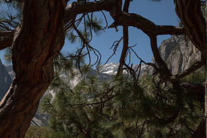 Mist Falls Hike Canyon ViewBack at our rock slab, the tripods came out, the family lined up and smiled, and we captured what I think is one of our best Christmas photos to date. Of note is that the boys coincidentally wore the same color shorts and t-shirts, just the way I used to dress them up in matching outfits for Christmas photos when they were little.
We also immortalized the first annual (and hopefully last) Gaidus “catching air” contest, in which we leaped as high as we could in the air, while doing some fancy moves. Mine looks like I just escaped from a mental hospital.
After a bit more lunching, lounging, and just taking in the expansive views of the canyon below, we retraced our steps back to the trailhead. Back at the homestead, we got take-out from the Cedar Grove Lodge and ate at a picnic table right on the banks of the south fork of the Kings River. The table was literally 10 feet from the river and the roar from the rapids was so loud that we had to practically shout just to hear each other. The food was just okay, but it was the only game in town and the scenery certainly made up for it. This was not exactly a culinary tour, but thankfully, we all think of food primarily as fuel to hike and have fun—except for Andrew, who is developing a taste for finer foods now that he is dating a culinary wonder.
 Mom Catching "Big Air" - AJGThe day was not over yet though. The sun was getting low, making it a perfect time to visit Zumwalt Meadows and walk the 1.5-mile loop around the meadow. The trailhead was back down the road towards Road’s End about 4 ½ miles from Cedar Grove Lodge.
This was one of those hikes that has a brochure you can purchase at the trailhead describing each of a series of numbered stops along the way. I was so used to reading these while the kids totally ignored me in years past, that I was pleasantly pleased to have Tommy take over my job and read each stop with interest—after all, he is a geoscience major and this valley has to be a geologist’s heaven. Despite Andrew’s major in environmental policy, he still felt it necessary to not give his brother the benefit of his full attention. One thing I did learn that I didn’t know before is that meadows are meadows and not forests, because they are too wet and frequently flooded to support much other than grasses and flowers. So, the brochure had already paid for itself.
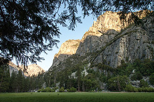 Zumwalt Meadows HikeAfter leaving the parking lot, we strolled along the banks of the Kings River before crossing a suspension bridge. At the junction for the loop, we chose to go left (clockwise), so that Tommy could do his brochure readings in the proper sequence. Unlike Yosemite, where one can wander freely across the meadows, this meadow was moister, and walkers are restricted to the path that traces its perimeter and the wooden boardwalks that cross it. We soon came to a wooden platform with a lovely view of the meadow and the granite walls of Grand Sentinel and North Dome rising from the right. Herb chose to remain here taking photographs during the sunset while the boys and I continued along the loop. As we rounded the halfway point of the meadow, our level forest path gave way to a section of large boulders at the foot of Grand Sentinel that required some rock scrambling to traverse. It was almost dark by the time we reunited with Herb sitting contentedly beside his tripod.
After a short drive back to Cedar Grove Lodge, we settled comfortably on the porch overlooking the Kings River, quite content with a very successful day of hiking.
Day 4 – Departure (with a quick stop at Muir Rock)
 Mon and Dad by Waterfall - TJGWell, it was time to leave Kings Canyon, but before doing so we had one last stop to make. Yesterday, after we finished our Mist Falls hike, we had totally forgotten our plan to stop at Muir Rock afterwards. Being great admirers of John Muir and all he has done to help create the National Park System, we thought it worth the drive back down to Roads End to pay him some well-deserved homage.
The rock, which is just a short walk from the Roads End parking lot, is a large flat boulder jutting over the river from which John Muir used to give talks on Sierra Club field trips. The rock was a perfect place to sun and jump into the river, and if it had been a wee bit warmer, I’m sure we would have given it a try.
But alas, we had places to go and people to see (Andrew’s girlfriend and family), so it was back in the car for the drive out of the park along the beautiful Kings Canyon Scenic Byway.
Description
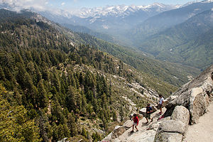 Descent from Moro RockSequoia and Kings Canyon are two very distinct parks administered as a single entity. Its combined 1,350 square miles make it larger than Yosemite, its more famous and visited neighbor a three-hour drive to the north. These two parks are home to the largest Giant Sequoia trees in the world, the largest mountain in California – 14,494-foot Mount Whitney, as well as one of the deepest canyons in the country.
Although John Muir made his first visit to the Kings Canyon in 1873, it took a bit longer for this area to be protected. Secretary of the Interior Harold Ickes recognized its uniqueness and fought to preserve it, even hiring Ansel Adams to photograph its beauty. Through their efforts, Kings Canyon was designated a National Park in 1940. The separate, tiny General Grant National Park was made part of Kings Canyon National Park.
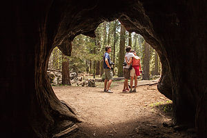 Family from Inside of a Burnt Out SequoiaThese two parks are well-kept secrets, with less than half the visitors that Yosemite receives each year. It is a place where one can find solitude from the crowds in a setting equally inspiring.
There are two main entrances to the parks, both located on the west side of the parks. There are no roads entering from the east. The Big Stump Entrance is reached via Highway 180 from Fresno and the Ash Mountain Entrance in the south is reached via Highway 198 near the town of Three Rivers.
Much of Sequoia and Kings Canyon is inaccessible by road. There are two major roads in the park. South of Grant Grove is the Generals Highway which takes you deep into Sequoia country with such notable stops as Giant Forest and Moro Rock (about a 2 hour drive from Grant Grove Village). North and then east of Grant Grove is the spectacular Kings Canyon Scenic Byway, a 31-mile rollercoaster road, which descends deep into the canyon, connecting Grant Grove and Cedar Grove. There are also a few additional out and back side roads off the two major roads.
The following is a list of highlights along the parks’ two major roads.
Generals Highway (from Grant Grove to Giant Forest)
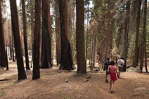 Hiking the Cresent Meadow trail
- Panoramic Point – at the end of a 2.3 mile steep and twisty spur road (no RVs allowed) is a overlook with incredible views of Kings Canyon below
- Grant Grove – paved ½ mile trail past a number of giant sequoias, including the General Grant Tree, the 3rd largest living tree in the world
- Giant Forest – the most famous grove of sequoias in the world. The General Sherman Tree, the largest living thing on the planet, stands at the northern edge of the grove. The 2-mile Congress Trail leads past the General Sherman Tree as well as several other well-known giants.
- Crescent Meadow – 3 miles off the Generals Highway on Crescent Meadow Road is this lovely meadow, ablaze with wildflowers in the spring. Another interesting stop along the trail is Tharp’s Log, a tiny cabin built from a fallen, fire-hollowed sequoia, complete with stone chimney. Named Tharp’s Log, it was built back in the 1860s by a cattle rancher named Hale Tharp. He was the first non-Native American settler to live in the area.
- Moro Rock – also along Crescent Meadow Road is Moro Rock, a large granite dome with 360 degree views of the surrounding snow-capped mountains of the Great Western Divide. The top of the rock is reached by climbing 400 steps carved into the side of the dome.
Kings Canyon Scenic Byway
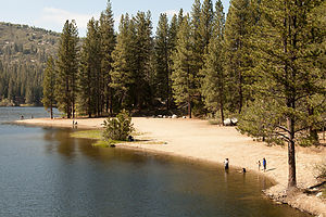 Hume Lake BeachThe Kings Canyon Scenic Byway is a 31-mile rollercoaster road connecting Grant Grove and Cedar Grove, which descends 2,000 feet deep into the canyon, It takes about an hour to drive and ranks among the most magnificent in any national park. The following are a few stops along the way:
- Cedar Grove Village – the only civilization in the wilderness – contains a small lodge and snack bar
- Roaring River Falls – a half-mile out and back walk to a magnificent view of the lower falls
- Zumwalt Meadow – a 1.5 mile loop hike around a lovely meadow with great views of Grand Sentinel and North Dome. The trailhead is 4.5 miles east of the turnoff for Cedar Grove Village and 1 mile before Road’s End.
- Road’s End – located at the very end of the Scenic Byway, Road’s End serves as the starting point for hundreds of miles of wilderness backpacking trails. A short walk from the parking lot is Muir Rock, a large flat boulder along the river from which John Muir delivered many of his Sierra Club talks. The trailhead for the very popular, 8-mile RT hike to Mist Falls is also here.
Although many try to see these two parks in just a day, it is best to stay a few nights to see all the parks have to offer.
For RVers, there are several campground choices.
Along the General Grant Highway:
- Azalea (114 sites) near Grant Grove
- Dorst (218 sites) 14 miles northwest of Giant Forest
- Lodgepole (250 sites) 5 miles northeast of Giant Forest Village
At the end of the Kings Canyon Scenic Byway near Cedar Grove:
- Sentinel – open whenever highway 180 is open
- Sheep Creek, Canyon View, and Moraine – open when overflow is needed
For those looking for lodging, there are also several choices
Along the General Grant Highway:
- John Muir Lodge – cozy 36-room lodge located near Grant Grove
- Grant Grove Cabins – 50 rustic cabins located near Grant Grove
- Wuksachi Lodge- modern 102-room lodge is located in the Giant Forest area
At the end of the Kings Canyon Scenic Driveway there is only one choice:
- Cedar Grove Lodge – lovely 21-room lodge on the bank of the roaring Kings River.
.
- 1 of 7
- next ›
Sequoia and Kings Canyon National Parks location map in "high definition"
Javascript is required to view this map.

That part of Cali is still a lusted after blank for us, too.
Other than our northwest coast trip, we've never been further west than Moab, it's just to hard to find that kind of time.
Maybe someday.
But I no longer fly, and hopefully never will again. When I travel, it's behind the wheel of my 2008 Monaco Knight. Anyplace I cannot get to in the time I can find, well, it's just not to be. Yet.
Jim