- Home
- About
- Map
- Trips
- Bringing Boat West
- Migration West
- Solo Motorcycle Ride
- Final Family XC Trip
- Colorado Rockies
- Graduates' XC Trip
- Yosemite & Nevada
- Colorado & Utah
- Best of Utah
- Southern Loop
- Pacific Northwest
- Northern Loop
- Los Angeles to NYC
- East Coast Trips
- Martha's Vineyard
- 1 Week in Quebec
- Southeast Coast
- NH Backpacking
- Martha's Vineyard
- Canadian Maritimes
- Ocracoke Island
- Edisto Island
- First Landing '02
- Hunting Island '02
- Stowe in Winter
- Hunting Island '01
- Lake Placid
- Chesapeake
- Provincetown
- Hunting Island '00
- Acadia in Winter
- Boston Suburbs
- Niagara Falls
- First Landing '99
- Cape Hatteras
- West Coast Trips
- Burning Man
- Utah Off-Roading
- Maui
- Mojave 4WD Course
- Colorado River Rafting
- Bishop & Death Valley
- Kauai
- Yosemite Fall
- Utah Off-Road
- Lost Coast
- Yosemite Valley
- Arizona and New Mexico
- Pescadero & Capitola
- Bishop & Death Valley
- San Diego, Anza Borrego, Joshua Tree
- Carmel
- Death Valley in Fall
- Yosemite in the Fall
- Pacific Northwest
- Utah Off-Roading
- Southern CA Deserts
- Yosemite & Covid
- Lake Powell Covid
- Eastern Sierra & Covid
- Bishop & Death Valley
- Central & SE Oregon
- Mojave Road
- Eastern Sierra
- Trinity Alps
- Tuolumne Meadows
- Lake Powell Boating
- Eastern Sierra
- Yosemite Winter
- Hawaii
- 4WD Eastern Sierra
- 4WD Death Valley +
- Southern CA Deserts
- Christmas in Tahoe
- Yosemite & Pinnacles
- Totality
- Yosemite & Sierra
- Yosemite Christmas
- Yosemite, San Diego
- Yosemite & North CA
- Seattle to Sierra
- Southwest Deserts
- Yosemite & Sierra
- Pacific Northwest
- Yosemite & South CA
- Pacific Northwest
- Northern California
- Southern Alaska
- Vancouver Island
- International Trips
- Index
- Tips
- Books
- Photos/Videos
- Search
- Contact
Ship Rock, NM
Wednesday, August 7, 2002 - 6:00am by Lolo
158 miles and 3.25 hours from our last stop
Travelogue
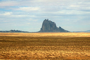
As we continued west across northern New Mexico on Route 64, we kept scanning the horizon hoping to catch a glimpse of Shiprock, the incredible 1,700 rock formation shaped like a Clipper ship. Herb spotted it first, from probably over 20 miles away, rising abruptly from the desert floor, the only thing breaking up the otherwise flat landscape. It really did look like a ship, complete with masts and sails.
 Ship RockI had done my research and knew that our closest view of it would be from alongside U.S. 666, about 6 or 7 miles south of the town of Shiprock. Getting any closer to it was not an easy option since the Navajo people view this rock as sacred and keep it off limits for fear of white men stirring up the souls of their dead ancestors.
So, we pulled over to the side of 666 to take some photos. Unfortunately, the fences and telephone lines made it difficult to get an unobstructed view, but we did our best. In his excitement to be the first to photograph the monolith, Tommy ran out of the RV barefoot onto the grass alongside the road, oblivious to the fact that the grass was full of burrs. Thank goodness for the surgical tweezers Herb carries in his first aid kit. It probably took him close to an hour to remove the tiny, yet quite painful, burrs. I think the souls of the ancient Navajo were making sure we didn't come any closer.
Description
Shiprock is a spectacular rock formation in northwestern New Mexico that rises 1,700 feet above a 5,500-foot-high plain. Early explorers named it "Shiprock" because of its resemblance to a 19th century Clipper ship. It can be seen from as far as 100 miles away.
The best places to view Shiprock are along U.S. 666, 6 or 7 miles south of the town of Shiprock. You can get closer by taking the tribal road to the community of Red Rock. Permission to go any closer must be obtained from the Navajo people, who view this rock as sacred and off limits to climbers.
The Navajo call the rock Tse'Bit'Ai, or "rock with wings." According to their legend, the Gods saved them from their enemies by causing the ground to rise, lifting them like a great wave away from their enemies to where Shiprock Peak now stands. The Navajos lived on the top of this new mountain, only coming down to plant their fields and to get water. One day while the men were working down in the fields, a storm came and lightning struck the rock, splitting off the trail and leaving only a sheer cliff. The women, children, and old people were stranded on the top and eventually starved to death. Because of this legend, the Navajos do not want any one to climb Shiprock Peak for fear of stirring up the souls of the dead.
- ‹ previous
- 16 of 36
- next ›
Ship Rock location map in "high definition"
Javascript is required to view this map.

I CLIMBED THE SPECTACULER ROCK AND FOUND THEIR TO BE VERY VALUBLE MINERALS AT THE TOP OF THE ROCK AND IT ALSO INCLUDED GOLD.