Death Valley National Park, CA

As I mentioned in the previous stop, I was not particularly thrilled about heading into Death Valley where the forecast was 105 to 110 degrees for the next few days. But it wasn’t just the oppressive heat that made me want to avoid this place. It was the horrible memories I had of losing our brake lines on the way out of the park in 2007 on the very road we would now be driving in on.
Route 190 into Death Valley from the west is extremely steep and twisting and doesn’t have just one mountain pass to cross, but two. However, we had just had the brakes completely redone again in 2014, so Herb felt confident that with proper downshifting we would not have a problem, and he was right. We didn’t. It just was a little nerve wracking. Plus, unless we planned to live in Death Valley, we would have to come out again.
Don’t get me wrong. I love Death Valley. It is breathtakingly beautiful and can be a wonderful place to explore – under the right conditions. The operative phrase is “right conditions,” and last November we had them – beautiful sunny skies with daytime temperatures in the upper 70s and lower 80s, dropping into the upper 50s at night. We were hiking and photographing all over the place.

Now, however, the air felt like you were being blown by a giant hairdryer on maximum heat. Fortunately, the Furnace Creek Campground where we would be staying the next two nights (it was originally three, but I negotiated Herb down to two) had a lovely warm spring fed pool, surrounded by palm trees and mountain vistas. It was truly lovely.
Within 10 minutes of checking in, we were at the pool and I had absolutely no plans of leaving it except to eat and sleep. Fortunately, we were able to get two lounge chairs that were at least partially in the shade.
Although I might have thought this was the absolutely worst time of the year to be here, European tourists do not. In fact, they prefer it because they want the “real” Death Valley experience, so the hotter the better. There were lots of them at the pool, looking a lot happier about it than I was. I would say that at least 80% of the people at the pool were speaking German, another 10% French or perhaps another European language, and then me and Herb.
The next day, there wasn’t even the slightest possibility of going on a hike, so first thing in the morning we hurried to the pool and grabbed our two favorite lounge chairs in the shade.
I have a hard time just sitting for long periods of time, so we tried to figure out something that to do at least for part of the day. A drive would be fine because we could be in air conditioning, so Herb suggested we go to Rhyolite, Nevada, just outside the eastern boundary of Death Valley -- a place he had been to on his motorcycle journey a few weeks back, but that I had never seen. He explained that there was a ghost town there as well as an outdoor art museum, two things he knew would tempt me.
Rhyolite was pretty amazing, so much so that I thought it warranted the dignity of its own trip stop, which follows this one.
What we didn’t know at the time we visited Rhyolite was that we would actually pass this way again the following day when leaving Death Valley for good, because a ranger told us that it was the least white-knuckling of the Death Valley exits. So what if that put us in Nevada. At least we wouldn’t have to drive the harrowing 190 through Stovepipe Wells and Panamint Springs again.
Note to self: Only visit Death Valley from October through March!
In 1994, the Desert Protection Act added an additional 1.2 million acres to Death Valley National Monument and upgraded its status to National Park, making it the largest national park outside of Alaska. The park is located on the eastern border of a remote section of California with some small portions extending into Nevada. Despite its remoteness, it is one of the most highly visited parks in the national park systems. Many of these visitors come all the way from Europe and Japan to experience the extremes of this stunningly beautiful desert.
Death Valley received its name from the unfortunate forty-niners who were forced to cross the burning sands here in order to avoid the severe snowstorns in the nearby Sierra Nevada on their way to the California Gold Rush. Many perished along the way, and those that survived remembered it as a place of suffering and death. The current names of many of the places in Death Valley reflect its harshness: Dead Man Pass, Funeral Mountains, Furnace Creek, Hell’s Gate, Devil’s Golf Course, Starvation Canyon, etc.
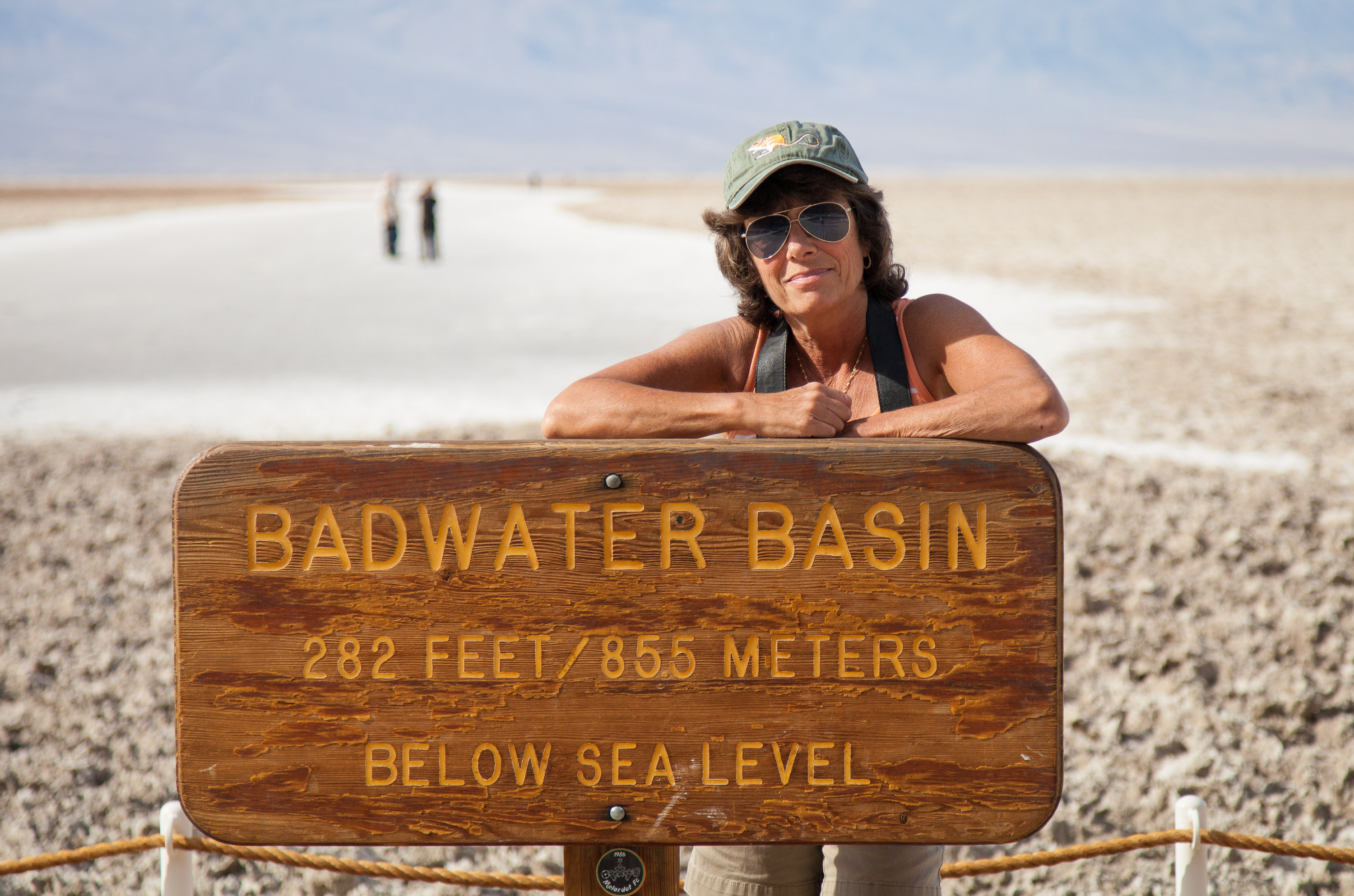
The valley itself is over 130 miles long, but only about 12 miles wide, flanked on both sides by unvegetated reddish mountains. From an elevation of about 3,300 feet in the north, the land slopes steadily downward to an elevation of 279 feet below sea level at Badwater, the lowest point in the western hemisphere. In fact, 70 miles of the desert floor is below sea level, accounting for its extremely high termperatures, which can exceed 130°F in summer.
In many ways, not much about the valley has changed since the pioneers first crossed here. Its intense heat, frigid cold, and the driest air imaginable still make it one of the most inhospitable locations on earth. However, today’s visitors can enjoy Death Valley and see most of its highlights from the comfort of their air conditioned cars and stay in comfortable, and even luxurious, hotel rooms at night.
The park is criss-crossed by a network of roads, ranging form washboard dirt ones to paved, well-maintained highways, making the most popular destinations quite accessible. The Furnace Creek Visitor Center, near the center of the park, is a great place to get oriented and to begin an exploration of Death Valley. This greenness of this area is a surprise to most visitors who come to the park expecting to see nothing but miles and miles of sand. Fed by warm springs, this area is a verdant oasis with palm trees as tall as 50 feet. There are also two world-class resorts here: the elegant Furnace Creek Inn and the more down-to-earth Furnace Creek Ranch.
Highlights traveling south from Furnace Creek on Route 190
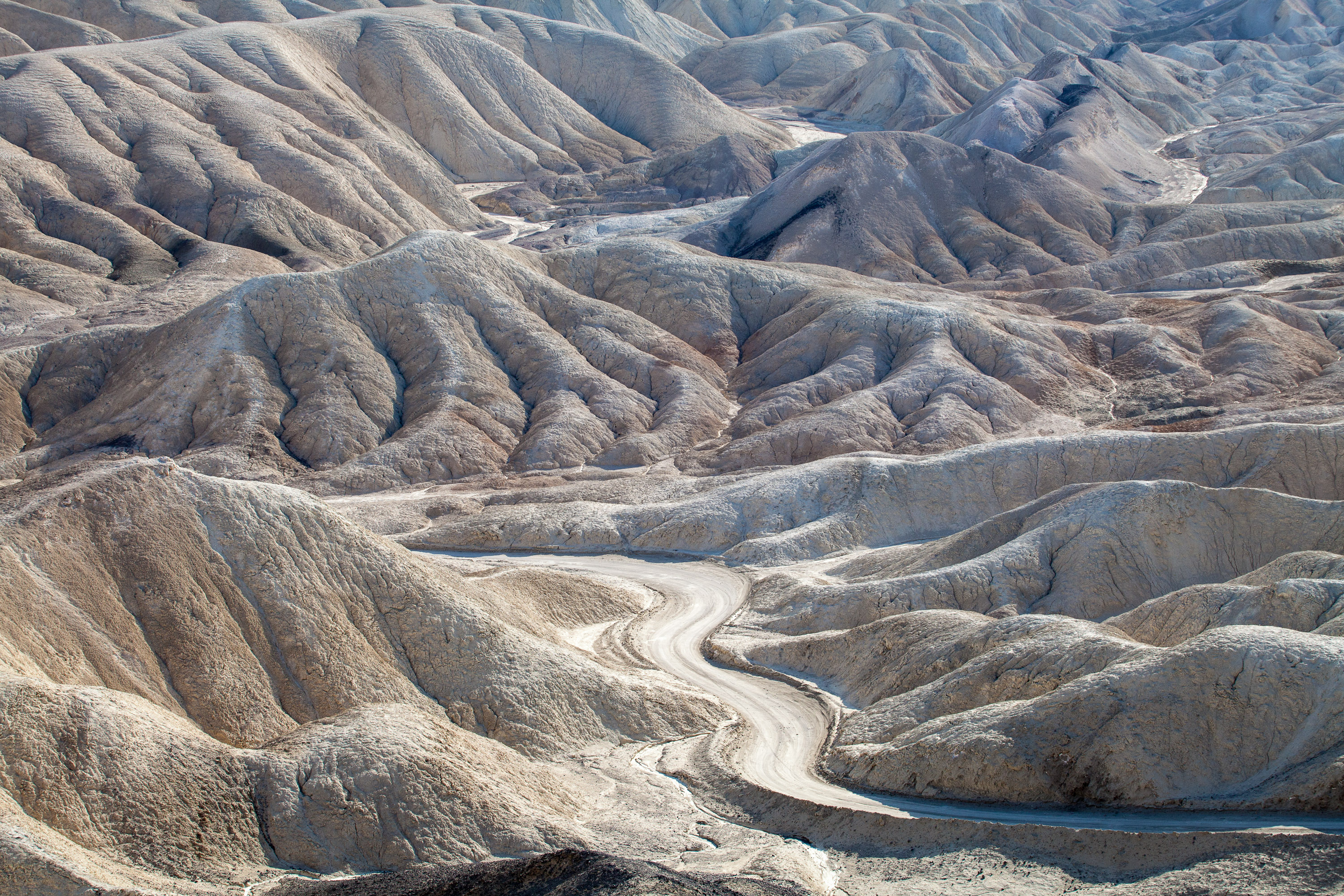
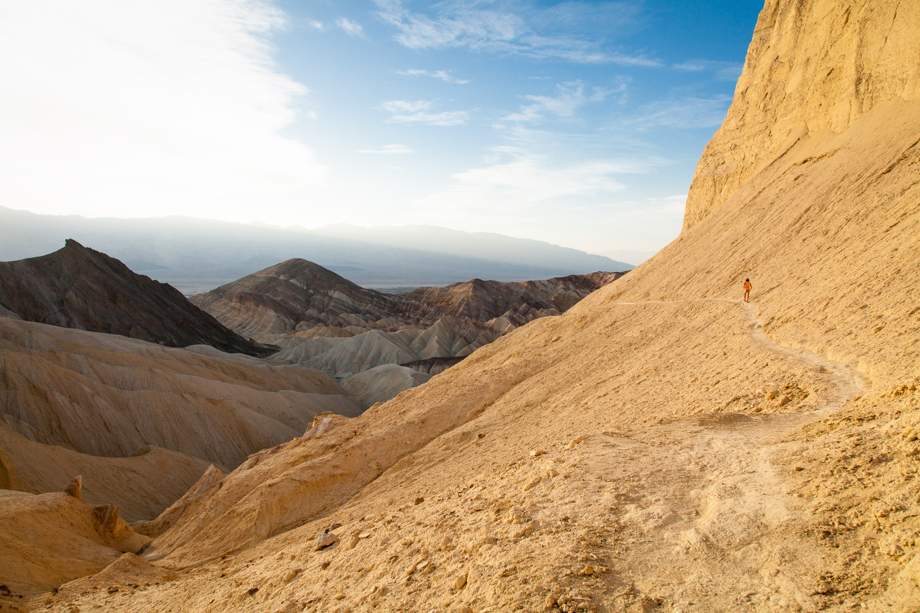
- About 5 miles south of the Furnace Creek Visitor Center is Zabriskie Point, one of the most spectacular overlooks in the park. A short walk uphill from the parking lot brings you to a panoramic view of Golden Canyon and the surrounding vibrantly colored badlands. The views are particularly stunning in the lowlight of early morning or late afternoon.
- Another 1.5 miles down the highway s the turnout for Twenty-Mule Team Canyon road, a one-way dirt road that rejoins the highway in 2.7 miles. The road winds through Twenty-Mule Team Canyon with close-up views of the same colorful badlands seen from Zabriskie Point. RVs and trailers are not allowed on this road.
- 4.5 miles further south on 190 is a turnoff for Dante’s View (restricted to vehicles less than 25 feet). The road to Dante’s View climbs steeply to an overlook 5,000 feet above the valley floor, where the temperatures average 20° F cooler than in the valley. From this viewpoint, which most consider the most breathtaking in the park, one can see the lowest point (Badwater) and the highest point (Telescope Peak) in the park.
Highlights traveling south from Furnace Creek on Badwater Road
- About 1.8 miles south of the Visitor Center is the turnoff for Badwater Road. 1.5 miles further south on Badwater Road is the parking lot for the popular hike into Golden Canyon. A well-marked nature trail (2 miles RT) leads into the narrow canyon, wedged in by eroded cliffs and the slopes of golden badlands.
- Back on Badwater Road, continue south past Artist Drive (get that on the way back as it is a one-way road going north). Around 9 miles south of Golden Canyon is the turnoff for the unpaved spur road to Devil’s Golf Course. The road leads to an odd and forbidding landscape created by salt and erosion on a lake bed that dried up 2,000 years ago. The result is a jagged terrain of salty white miniature mountains and spires, less than 2 feet high. The name comes from the feeling that “only the devil could play golf on such rough links.”
- About 8 miles south is the Badwater Basin, the hottest and lowest point in Death Valley accessible by car. Surprisingly, its permanent spring-fed pools also make it one of the wettest. Legend says that it got its name from a surveyor whose mule refused to drink it. Although not poisonous, it is similar in composition and taste to Epsom salts. Despite its apparent inhospitableness, it is home to water beetles, insect larvae, and a soft-shelled saltwater snail that slowly adapted to these conditions.
- Turning back north on Badwater Road towards Furnace Creek, in 8 miles you come to the turnout for the one-way, 9-mile paved Artist Drive, which winds through a colorful display of sedimentary and volcanic rock hidden from the main road. It received its name from the rainbow of colors—red, pink, yellow, orange, and brown—that paint these rocky hills. About half-way through the loop is the parking lot for Artists Palette, one of the most colorful areas along the loop. Artist Drive is restricted to vehicles less than 25 feet.
Highlights traveling north from Furnace Creek on Route 190
- About 1.7 miles north of the Furnace Creek Visitor Center are the remains of what was once the Harmony Borax Works. Borax, which the prospectors called “white gold,” was once a big business in Death Valley. In the 1880s, Chinese laborers were hired to rake borax “cottonballs” from the valley floor and bring them to the Harmony Borax works to be purified. From there the refined borax was loaded onto the famous twenty-mule team wagons and transported 165 miles across the desert to the train station in Mojave. From there it was shipped to processing plants where it was used to make soaps, disinfectants, and food preservatives. Between 1883 and 1927, more than $30 million worth of borax was produced in Death Valley. A short trail leads past the ruins of the old borax refinery and some outlying buildings. More information on the mining of borax in Death Valley is available in the Borax Museum at the Furnace Creek Ranch.
- 12 miles further north on 190 is the turnoff for the 1.2 mile gravel road to Salt Creek, home to the famous Death Valley pupfish. When the lake that once covered Death Valley dried up thousands of years ago, the desert pupfish was the only fish that managed to adapt to the harsh conditions here. Isolated from each other in scattered salty pools, springs, and creeks, nine types of pupfish have evolved. A tenth has already become extinct. They are found no place else on earth. The pupfish can often be seen from the short wooden boardwalk nature trail that crisscrosses the stream and marshes.
- About 21 miles north of the Visitor Center, Highway 190 turns west towards Stovepipe Wells and the west entrance to the park. At this point, you can either continue on 190 or head north on the North Highway another 32 miles to Scotty’s Castle, the major man-made attraction in Death Valley.
Highlights along the North Highway (traveling north)
- The drive to Scotty’s Castle on the North Highway is a very scenic one with desert stretching out on the west and mountains rising to the east. About 10 miles north on the North Highway is a pullout with great views of Death Valley’s renowned alluvial fans. These fans are something like an hourglass with debris from the mountains funneling through a narrow opening and spilling out in a wedge shape into the valley. They come in many shapes and sizes. The ones near this viewpoint are smaller and steeper.
- 25 miles further north in the remote Grapevine Canyon looms the unlikely sight of a Moorish Castle. Construction of what was more officially called Death Valley Ranch was begun in 1922 by Chicago millionaire Albert Johnson, whose doctors had advised him to spend more time in a warm, dry climate. However, the mansion is known as Scotty’s Castle, named after Johnson’s unlikely friend, Walter Scott. Walter Scott was a cowboy that had traveled with Buffalo Bill’s Wild West Show in the 1880s before taking up prospecting. Albert Johnson was one of Scotty’s gullible investors in his “secret gold mine” in Death Valley. After several trips west to see the mine, Johnson realized that he was being duped by Scotty. Despite that, Johnson truly enjoyed his new friend and the tall tales he told. Scotty helped Johnson conceive the idea of this vacation villa in Death Valley and lived in it after Johnson’s death.
- In 1970, Scotty’s Castle was purchased by the National Park Service from the foundation to whom Johnson had willed it. Today the colorful history of the castle is brought to life by rangers dressed in 1930s clothing that welcome you as if you were Scotty’s guests. The one-hour guided tour is excellent, both for its inside look at this unusual mansion as well as for the stories about the eccentricities of the two men that built it. Tours depart every 20 minutes from 9 am to 5 pm. Plan to arrive early because they fill up quickly.
- About 1.5 miles down Grapevine Canyon heading back south on the North Highway is the turnoff for the 8 mile road to Ubehebe Crater. This half-mile wide, 600-foot deep crater was formed by volcanic explosions several thousand years ago. Dark cinders and volcanic fragments cover the surrounding countryside. From the parking area there is a steep trail up to the crater’s rim. Be prepared to battle some very gusty winds.
- Because of its remote location, few visitors get to see the famous Death Valley Racetrack, where rocks mysteriously move across the dry lakebed on their own accord. Although no one has actually seen the rocks move, they are known to move because of the trails they leave behind them. After studying the phenomenon for decades, scientists now believe they have solved the mystery. The surface of the lakebed is a fine clay that becomes very slippery when wet. After a rain, heavy winds as high as 70 mph blow the rocks across the slick surface. A 4-wheel drive vehicle is needed to reach the Racetrack, which is 27 miles past Ubehebe Crater on a rough dirt road.
Highlights traveling west along Route 190 from the junction with the North Highway
- Just west of the junction is the parking area for the surrealistic Devil’s Cornfield. On both sides of the road are odd-looking clumps of brush four to ten feet tall that resemble corn stalks. They are actually arrowweed bushes, whose stems were used by Native Americans to make arrow shafts.
- A few miles further west on 190, pull over on the shoulder by a roadside display where the Sand Dunes come close to the highway. These are the highest of a 14-square-mile field of dunes. Although there are no trails to follow, hikers are free to roam the dunes on their own. The best time of day to visit the dunes is in the morning or late afternoon when the temperatures are cooler and the lighting is more dramatic.
- Two miles further west is the village of Stovepipe Wells, Death Valley’s first tourist resort. The village actually got its name from an historic site about 5 miles north where an old stovepipe was sunk into the sand to form the shaft of a well. For years this well was used by travelers as a source for water. Around 1926 a developer planned to build a small resort near the well. However, his lumber trucks got stuck in the sand before he could reach it. Rather than unload and reload his trucks, he decided to try and dig a well where they were. They struck water and stayed. That spot is the current location for Stovepipe Wells. Today the village has a motel, general store, saloon, restaurant, and campground.
Campgrounds that will accomodate RVs in Death Valley
- Furnace Creek Campground (136 sites, no hookups) – located just north of the Visitor Center. Open year round. This is the only park campground that takes reservations.
- Mesquite Spring Campground (30 sites, no hookups) – located 5 miles south of Scotty’s Castle. Open year round.
- Panamint Springs Resort (40 sites, 12 hookups) – located 30 miles west of Stovepipe Wells on Route 190. Open year round. This campground is privately operated and takes reservations.
- Stovepipe Wells Campground (200 sites, 15 hookups) – located in the village of Stovepipe Wells. Open year round.
- Sunset Campground (1000 sites, no hookups) – located .25 miles east of the Furnace Creek Ranch. Open October through April.
- Texas Spring Campground (92 sites, no hookups) – located near Sunset Campground. Open October through April.
- Wildrose Campground (30 sites, no hookups) – located 30 miles south of Stovepipe Wells off the Trona-Wildrose Road. Open year round.
In addition to the park campgrounds, there are two privately-owned campgrounds in the park:
- Furnace Creek Ranch Campground (26 sites, all full hookups) - located at The Ranch just south of the Visitor Center. Open year round. Guests can enjoy the Ranch’s natural spring-fed swimming pool, shower facility, coin operated laundry, tennis courts, shuffleboard, volleyball, Bocci Ball and basketball court.
- Panamint Springs Campground (37 sites, 12 full hookups) - located at the western end of Death Valley National Park on Highway 190 in the town of Panamint Springs