Eastern Sierra - North (June Lake, Lee Vining, Yosemite, and Bridgeport), CA
Day 1 – Death Valley to June Lake

Before leaving Death Valley for the last time, we took advantage of the Furnace Creek Ranch hot springs pool for one more time. It isn’t often you come across such a lovely resort-like setting when camping.
Our goal was the June Lake and Mono Lake area back on the other side of the Panamint and White Mountains, but we wanted to get there with the least amount of harrowing mountain passes. A ranger at the Visitor Center suggested that we go out the east entrance of the park towards Beatty, Nevada and then take 95 north up to Tonopah and then head west. It meant adding a few miles and repeating our drive to Rhyolite the day before, but we didn’t really care if it meant we would have a more relaxing drive.
The ranger was right, and this route was much less nerve wracking than our way in. There was only one steep twisty part near Benton Hot Springs, but after that, the drive along Highway 120 (also called the Mono Mills Road) west into Lee Vining was beautiful.

When we got to Lee Vining, we headed south on Highway 395 with the intention of camping along the June Lake Loop. There are several forest service as well as commercial campgrounds along the loop, but it was a Saturday, so we hoped we wouldn’t have a problem.
The first lake we encountered on the Loop was Grant Lake, which is the largest of the four lakes along the drive. It was terribly low, and the whole southern section was bone dry. The multi-year drought in California was certainly taking its toll.
When we got to Silver Lake, we pulled into the Silver Lake Resort, a commercial campground right across the road from the lake by the same name, to inquire if they had a spot for us for the night. While the woman was hesitating about whether she wanted to give us a spot for just one night, we had a chance to look around and saw that the motorhomes were packed in like sardines. Before she got a chance to turn us down, we told her never mind and continued along the drive. I think the term “Resort” is used far too lightly.

Next we pulled into the June Lake Campground, a forest service campground which was much nicer, but small and totally full. I was starting to get a bit concerned - we were almost to the end of the June Lake Loop road.
We saw a sign for the Pine Cliff RV Resort – oh good, another resort – and turned in. While I was waiting on line at the office to inquire about a site, Herb walked over to the nearby Oh! Ridge forest service campground. Although there was only one man ahead of me on line, it took the poor woman, who must have been a trainee, literally 20 minutes to check him in. It was a good thing, because before she got a chance to wait on me, Herb ran into the office and said, “Don’t do it! I found something much better.”
He was right. The Oh! Ridge campground was beautiful – spacious sites and beautiful views of the lake and mountains.
When we took a walk through the campground later that evening, we ran across our new friend Bill with the Lazy Daze motorhome, whom we had met a few days back at the Boulder Creek Resort in Lone Pine. He and his friend had had quite a successful day fishing in the lake and were planning to get up early to do some more of the same.
Day 2 – Panum Crater and Parker Lake Hikes

It was a beautiful day for a hike, so we set out towards Panum Crater on the southern end of Mono Lake, not too far from Navy Beach and the South Tufa Reserve where the spectacular “tufa towers” are. Since we have seen the tufas several times, both from land as well as from our kayaks, we were ready for something new.
To be honest, despite having been here several times, I never even knew this crater was here. It was only when scanning our California hiking book for ideas that I found it. Herb and I love a good crater. We have become volcano groupees since the boys moved out West and we spend lots of time traveling between San Francisco and Seattle. Eventually, we hope to collect them all.
This one, which is a perfect example of a rhyolitic plug-dome volcano, is pretty small by volcanic standards – 220 feet high and 2,000 feet across. It last erupted in 1325 AD.

From the parking lot at the end of a dirt road off Highway 120, we hiked up to and along the crater’s rim. The entire hike around the rim is about 2 miles, and the views along the way of Mono Lake and the Sierra are really beautiful.
About 1 ½ miles around the rim (if you are going counterclockwise), there is a short side trail down into the lava dome at its center where there are bizarre rock formations and huge chucks of obsidian everywhere.
The entire hike, including down into the dome, is about 2 ½ miles and takes about an hour and a half. The best thing about a short hike is that it allows enough time to do another one, and this time we chose one of a different sort – the hike to Parker Lake.

Although Park Laker is one of the lakes in the June Lake Loop area, it is not located along the road, but rather in a small canyon high above it. Most people driving along the loop, never even notice the sign for the turnoff to the trailhead. I don’t think we would have either, if we hadn’t been specifically looking for it. It’s located about 1.3 miles from the north end of the June Lake Loop. From there, we had to drive about 2.4 miles on a bumpy dirt road to the trailhead.
There were only two other cars in the small parking lot, which meant that we would pretty much have this trail to ourselves, which was nice. From the trailhead, we hiked through a sagebrush plain and then into a lovely forest of quaking aspens and Jeffrey Pines, with pretty Parker Creek flowing alongside us on our right.
After about a mile, we met one other hiker on his way out. He told us that it was possible to walk all the way around the lake as long as we were willing and able to scramble across logs and rocks to get across several stream crossings. We would have to see about that.

At 1.9 miles, the forest opened up and revealed a beautiful, crystal clear, deep blue lake at the foot of 12,861-foot, snow-covered Parker Peak. Wow! There was a lot of bang for our buck in this hike – so much amazing scenery for so little effort. I guess it helped that we had been in the Sierra for awhile and had gotten acclimated to the altitude, because the lake itself is at 8,318 feet.
We started scouting out whether there was an acceptable way for me to cross the fairly deep and rapid creek so that we could walk around the lake. I wasn’t exactly excited about it, but I wasn’t about to be the reason we didn’t, so I used my usual awkward, 5 point method, where I slithered on my butt across the logs and branches.
Once I finally got across the stream, we traced the shores of the lake, but there really was no clear trail to follow. We couldn’t get lost because the lake was right to our left, but we did have to bushwack a bit on the overgrown trail and get our feet wet several times. I don’t think many people do this. There really is no need to as the best views are from the shore that we first encountered at the end of the real trail. I guess it had to be done though.

The hike back out was easy, and it wasn’t long before we were back at our campsite at Oh! Ridge, sipping Chardonnay and gazing out over June Lake below.
It had been a great day with two great hikes. I am always amazed when we are out West how much variety there is in such a small geographical area. One minute we were hiking on cinders and ashes along a treeless volcanic crater rim and the next we were hiking through a beautiful forest of quaking aspen and Jeffrey Pines on our way to a pristine mountain lake – and they were only, 10 miles away from each other. In New Jersey, I can barely get from one shopping mall to the next in that short a distance.
The hikes did have something in common though -- those beautiful snow-covered Sierra always in the background. I’m going to miss them when we go back home.
Day 3 – Lundy Canyon and Travertine Hot Springs

Although we were at the doorstep to Yosemite and tempted by all it has to offer, we had not yet even come close to exhausting the wonderful hiking opportunities in the wilderness areas just outside its eastern boundary.
For today, we chose to do one of the classics – the hike to Lundy Canyon in the Hoover Wilderness Area, known for having some of the best waterfalls in the Eastern Sierra.
From the town of Lee Vining, we drove 7 miles north on 395 and then turned left on Lundy Canyon Road. After 5 miles we passed Lundy Lake and continued for another 2 miles on a dirt road to the trailhead. We were very lucky to get the last parking spot in the small lot. Most of the people in the lot were getting ready to set off on a multi-day backpacking trip, as the Lundy Lake trail is the backdoor into the 20 Lakes Basin Area, and many people use this as their starting point.
The girls that were parked next to us were packing up to take a group of teenagers on a backpacking trip to Saddleback Lake, about 6 miles up through the canyon. They had extra food that needed to be left behind and were concerned by the lack of bear boxes at the start of the trail, which was rather unusual since we were in black bear country. One of the girls told us that she had already had her car door ripped off 4 times by bears trying to get at the food inside it. She had no desire to go for a fifth, so she actually got back in her car to go look for a place where her food could be safely stored while they were away. Before setting out, we did a double check to make sure that there was nothing that would be tempting for a bear left in our car.

We followed the trail through a grove of quaking aspen and in about a quarter of a mile came to a pond with a lovely view of Lower Mill Creek Falls and the snow-covered peaks of the western end of Lundy Canyon. Fortunately there was another couple there, so we took turns taking photos of each other.
At about ¾ miles we came to the Lower Mill Creek Falls, the first of the two waterfalls we would get to that day, and the one we had used as a backdrop for our picture at the beginning of our hike.
The trail traced Mill Creek for much of its way, and there were several spots where we had to cross it, hopping over rocks and logs. There were also several impressive beaver dams, which have created small ponds within the creek. .
After about another mile and a quarter of easy hiking through forest and meadow, we came to our turnaround point and the Upper Lundy Falls, the second of the two waterfalls on our hike. From this point, the trail rises steeply and somewhat treacherously up the canyon wall. Our hiking book warned about this section of the trail being steep and slippery with loose scree, making it possible to take a serious fall, especially if wearing a heavy backpack. Most day hikers turn back at this point, and we would as well. We did, however, go a short distance along the canyon wall, mostly so I could get to a little snow pile and make a snowball.

On our way down, a nice, flat rock ledge above the Upper Falls called out to us, so we answered and sat for awhile enjoying the beautiful scenery and our picnic lunch.
The entire hike, out and back, was 4.4 miles with a 1,000 foot elevation gain and an awful lot of awesome scenery along the way.
We still had the whole afternoon ahead of us, so we drove north on 395 for about 17 miles to the turnoff for Travertine Hot Springs in the town of Bridgeport. Last summer, this had been the site of our first natural hot springs experience, and it had set the bar very high in terms of ease of access and a beautiful setting.
We knew enough to pass right by the partially-developed pool at the edge of the parking lot and continue down a short trail to the main pools, which are fed from water trickling over the edge of a colorful, “travertine”-stained rock formation that rises above them. Rock piles separate the water into three separate pools, with water flowing from one pool to the next, decreasing in temperature as it goes along. The rightmost pool, which has stone sides to sit on, is about 105 degrees; the middle pool also has stone sides and is about 100 degrees; and the leftmost pool has a mushy mud bottom and is about 90 degrees.

There is always someone in the rightmost pool, but the others are sometimes available. I’m not sure what the etiquette is in terms of joining people already in a pool if another one is empty, so I tend to not join. Herb takes the privacy thing a step further and goes across the field to a primitive pool that he likes to think of as his own. The whole area around the springs is very active geothermally, so new springs are continuously erupting forming new pools. However, “Herb” pool was here when we visited last year.
A gentleman, who was just leaving “Herb” pool, showed us how to regulate the temperature by using a rock to either block or open up the flow of spring water into it. It was surprising what a difference it made. Although I love sitting in my beach chair by this pool looking out at the Sierra and the town of Bridgeport below, I am not a fan of its muddy bottom. So, I kept watch over the three main pools, and when I saw the middle one free up, I would go there to soak for awhile. Just like in the “Three Little Piggies,” for me the middle pool was “just right” – good temp and stones rather than mud to sit on.
That evening we returned once more to our campsite at Oh! Ridge on June Lake and discussed the plan of attack for the next few days. We tried to sit out in our beach chairs to have a glass of wine and watch the sun set over the lake, but it was just too cold and windy. Oh! Ridge is, after all, at an elevation of 7,600 feet. Herb hates the cold and is terribly offended if he can’t sip wine outside in the summer, so, we agreed that the next day we would move to the Mono Vista RV Park in Lee Vining, which is at 6,300 feet, to see if that was any better.
Day 4 – Dog Lake, Lembert Dome, and Tuolumne Meadows

The next morning we implemented our plan of moving our base camp from Oh! Ridge Campground on the June Lake Loop to the Mono Vista RV Park, just 15 miles up 395, but 1,300 feet closer to sea level.
Now we were just too close to the Yosemite entrance to resist its lure any longer, so we dropped the motorhome off at its new home and drove the Subaru into the Park. Every bit of elevation we lost driving down to Mono Lake, we regained and more. Beautiful Tuolumne Meadows sits at 8,600 feet, which is why even in late spring and early summer, the Tioga Pass Road sometimes closes due to snow.
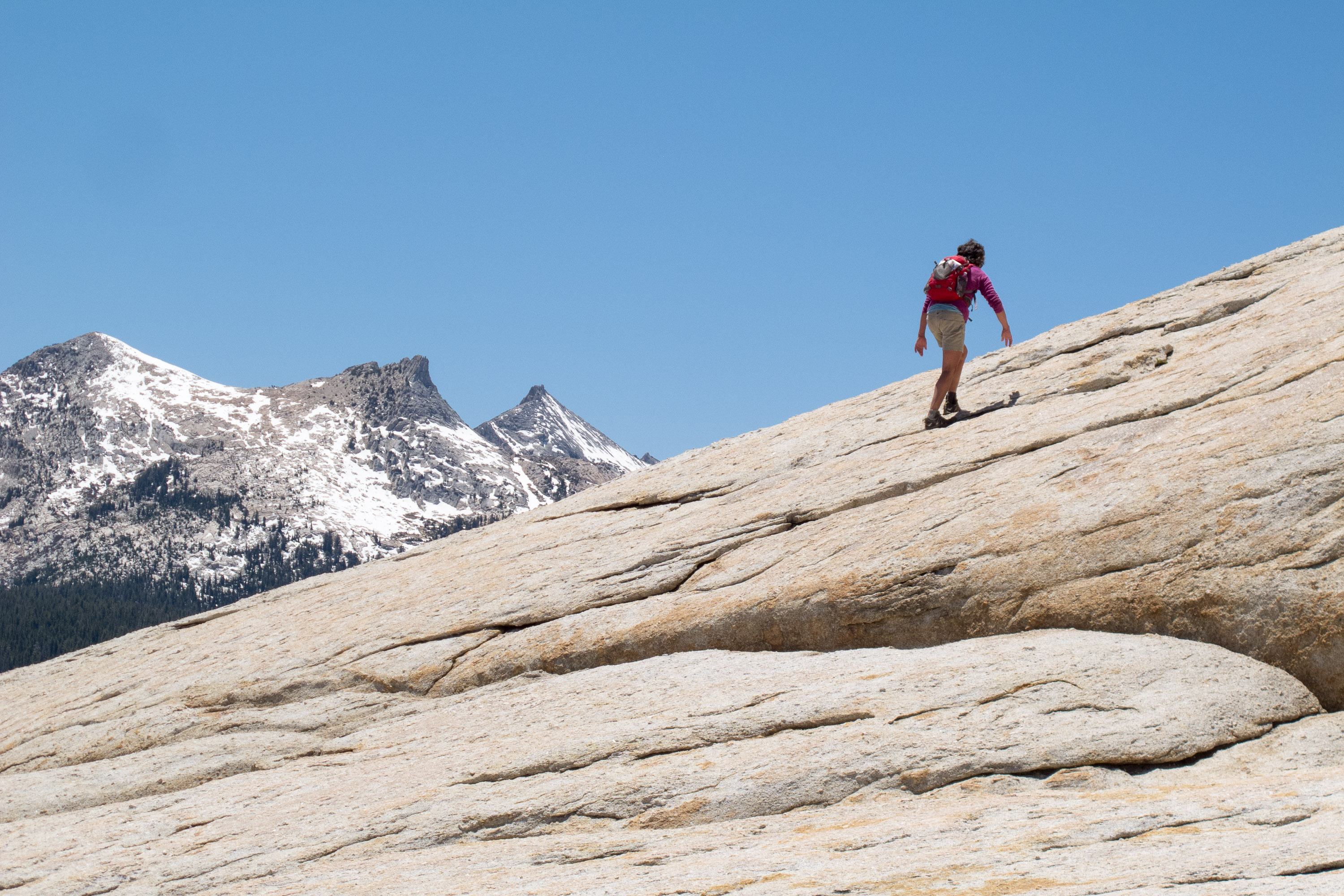
We have done many day hikes and even a backpacking trip from Tuolumne Meadows, but for some reason we have never done the classic hike to the top of Lembert Dome. While Tuolumne Meadows is full of domes, Lembert Dome is probably the most iconic and the one that dominates the eastern end of the meadow.

Like most domes, Lembert Dome has a steep face, which rock climbers like to play on, and a more gentle, yet still steep, backside that hikers can scramble up. I think we parked in the climbers’ rather than the hikers’ parking lot, because what we were looking at hopefully wasn’t its gentle backside. However, the trailhead did say Dog Lake and Lembert Dome. We would just have to hike a little longer to get to the backside, which was fine.
After hiking for about a mile along a trail along a wooded slope, we came to a trail junction – Dog Lake 0.4 miles straight ahead, backside of Lembert Dome 0.5 miles to the right. We went straight and soon came upon the south edge of Dog Lake, with views of Mount Gibbs and Mount Dana in the distance to the east. Although not as dramatic a setting as some of the other high country lakes we have hiked to, it was still a very lovely and peaceful spot.
We continued along the lake’s shoreline on an obvious path –much easier than our bushwhacking / stream crossing experience the other day at Parker Lake. Soon we came upon a nice sandy beach, which someone had already claimed. If it had been a little later in the summer season, I would have loved to have gone for swim, but the water was still too chilly, at least for me.
After our trip around the lake, we hiked back down to the trail junction we had passed earlier, took a left turn towards Lembert Dome, and after a half mile came to a sign pointing us to the right to ascend the backside of the dome. There is no official path to the top, so you have to figure out your own way up the steep granite slabs. I chose to follow a large crack, because it gave me the security of grabbing onto something if necessary.

Although a little bit intimidating, it was nothing compared to going up the backside of Half Dome. There it is so steep that they have installed cables to hold onto as you ascend. Still even on this dome, there were more people choosing not to go up to the summit than did than to do so, which was good in that it gave us the top to ourselves. From the summit there is a wonderful panoramic view of the Cathedral Range to the South, the Sierra crest to the east, and Tuolumne Meadows to the west.
In retrospect, I really hope that we made it to the true summit. I read afterwards that there are several false summits, plus our Strava mapping of our hike seemed to show us a little bit to the right of the summit. I don’t know how that could be though. There was nowhere else to go up. I am going to officially count it as having reached the summit.
As always, the going down a steep surface is much scarier than going up. Going up you can at least reach your hands out and touch the rock for security, but going down you feel much more exposed. I admit to resorting to my trademark five-point contact method where I use my butt, hands, and feet to maneuver down the steeper parts. I didn’t care what I looked like.

Once back on flatter ground, we continued back to the trail junction, turned right, and hiked about 0.3 miles down to the road to a parking lot that I think was the one that we should have to do this hike. From there, it was a long walk back to our parking lot (1.2 miles according to Strava) along a trail that ran alongside the road.
All totaled, our hike was 6.1 miles with an 900 foot elevation gain, but believe it or not, 600 of that elevation gain was made getting to Dog Lake.
Before returning to Lee Vining, we drove west a bit further along the Tioga Pass Road as far as beautiful Tenaya Lake, looking for a place to set out our beach chairs to just relax and enjoy the scenery. The lake was pretty busy with picnickers, so we found a quieter place where the Tuolumne River runs through the meadow. It was lovely.
The drive back to our campsite at Mono Vista RV Park in Lee Vining was only ½ hour. Although we much prefer staying in the Park, it was good to find a viable base camp alternative for future visits to Yosemite.
Day 5 – Black Point Fissures, Buckeye Hot Springs, and Travertine Hot Springs

Today we decided to explore another one of Mono Lake’s volcanic features – the Black Point Fissures atop a flat-topped volcano along the north side of the lake. Black Point last erupted about 13,000 years ago when it was still beneath the water of what was a much deeper Mono Lake. When the cinder and lava cooled and hardened under water, the top split open to form several hundred-yard-long cracks, or canyon-like fissures, measuring from 20 to 50 foot deep and only a few feet wide. When the waters of Mono Lake receded after the Ice Age, Black Point became a peninsula. It is the only fully exposed underwater volcano on earth.
It is the fissures that make this place so interesting, but since they lie below the surface of what is now a rather indistinct flat-topped volcano, they are not that easy to find. If fact, even getting to the trailhead was a bit of a challenge, though not nearly as bad as the ranger in the Mono Lake Visitor Center had described it.

From our campsite in Lee Vining, we drove 5 miles north on 395 and turned right onto a paved road marked County Park. We stopped briefly at the park and walked along a boardwalk to the north shore tufa area and wetland. The lake has receded quite a bit over the years, so there are several tufas left stranded on the shore. There was a very large, bright white one just alongside the boardwalk, so close that I could have touched it, but didn’t because I thought that might not be good for it.
After the park we continued along the road, which eventually became dirt, for another 3.4 miles and then turned right on another dirt road signed for Black Point. Then it was 3 miles more along dirt to a parking lot marked for Black Point.
From the parking lot, you couldn’t really see much of anything, or for that matter, where you were even supposed to go. Unlike other volcanic features that rise above its surroundings, these fissures were below the surface and not visible until you were at their edge. All we saw was a gently sloping hill covered in ash, cinders, and sagebrush.

Since there is no official trail up to the fissures, we just followed the footprints, wherever they lead, but all too often there were footprints in every direction. As long as we kept going up, we figured we would be getting closer. Eventually we left the sagebrush behind and reached a rocky promontory, which appeared to be the highest point.
While we were trying to figure out which way to go from here, we sat on the rock and looked out at the spectacular scenery -- Mono Lake and the snow-covered Sierra. From this vantage point we had a great view of the lake’s two islands – Negit, the black island which erupted 1,700 years ago and Paoha, the white island which erupted only 250 years ago. When we visited Mono Lake last year we kayaked the 3 miles from the lake’s southern shore to Paoha and spent half a day exploring it. We didn’t realize at the time how lucky we were to be able to do that. Usually the lake gets too windy by early afternoon to be out on it.
We saw people to the southwest of us where there appeared to be rocky cliffs, so we headed in their direction. Finally we came to a large crack in a rock that dropped down about 30 feet into a narrow canyon. The entry was gently sloping enough for us to easily enter and come out again at a later point.

We thought this was pretty cool and that we had finally found the fissures. I guess we did, but there were much better ones a little further – I wish I could say where, but we have no idea how we got to them. These were deeper (maybe 40 to 50 feet high), narrower (only a couple of feet wide), more colorful, and had walls covered with unusual knobby features that were attached to the walls like barnacles.
I don’t know if we saw all the fissures, but I think we saw enough to have made the trek searching for them worth it.
The way down was much easier to navigate as we could see our car in the parking lot. Good thing, because it was easy to get distracted by the expansive views before us of Mono Lake and the surrounding mountains.
Rather than return to Lee Vining, we continued north on 395 towards the town of Bridgeport to soak in Buckeye Hot Springs, another natural hot spring that we had read about in our guide book.

This one was a bit harder to get to than Keough Hot Ditch or Travertine Hot Springs. We drove past the turnoff for Travertine Hot Springs and after passing through the north end of Bridgeport, we turned west onto Twin Lakes Road and continued for seven miles. Just past Doc and Al’s resort, we turned right and crossed a bridge going over a creek. From there, we continued on a gravel road up a hill, past the Buckeye Campground, to a parking area at the very top of the hill.
There was one pool located under a tree near the parking area, but it was not very inviting – too cool and slimy. The main pools were located right alongside Buckeye Creek, but required going down a short, steep trail to reach them. I made Herb scout it out first to see if it was worth me going down as well and whether we should bring beach chairs. He came back up and said no to the beach chairs but yes for me.
We grabbed towels and a cooler and hiked back down. These pools were very different than Keough and Travertine in that they were directly next to a creek, separated from its chilly waters only by man-made rock piles. The source of the spring was on top of the grassy hillside that we had just climbed down. The water emerged from the spring at about 140 degrees and flowed down, cooling along the way, until it cascaded over a cave into the largest pool, forming a nice little waterfall. Additional rock piles separate the hot water area into three separate pools, varying in temperature from 95 to 110 degrees.

I chose the pool with the waterfall, and squished back as far as I could against the cave wall, so that I could enjoy the waterfall cascading down in front of me without getting pelted in the face. It was nice sitting in the warm pool and listening to the babbling brook, but we prefer the more expansive views we had at Keough and especially at Travertine. So, after a little while, we trekked back up the hill and drove to Travertine, which was on the way back to our campground anyway, and spent an hour there enjoying our soak with a Sierra view.
That evening we went out on the town for dinner at our favorite gas station restaurant – in fact, I believe it is our only gas station restaurant. Although technically located in a Mobil station, Whoa Nellie’s Deli is in a separate building and has quite an exotic menu. For example, Herb and I ordered Lobster Taquitos on a bed of Brazilian black beans and Wild Buffalo Meatloaf cooked cowboy style. You can even get wine and beer. The place was bustling. I highly recommend it to anyone coming into Yosemite via the east entrance.
I have broken up our journey along the Scenic Byway into two stops:
• South - from Mammoth Lakes to Lone Pine
• North - from June Lake to Bridgeport
The following is a description of a few of the stops we enjoyed along the Eastern Sierra northern section:
June Lake Area
The June Lake Loop, also known as Highway 158, loops away from Highway 395, just north of Mammoth Lakes, follows a horseshoe-shaped canyon for 16 miles, and then returns to 395 just south of Lee Vining. Along these highly scenic miles, it passes four lakes – June Lake, Gull Lake, Silver Lake, and Grant Lake -- each with dramatic mountain backdrops. There are campgrounds at each of the lakes. Activities along the loop include: world-class trout fishing, swimming, boating, hiking, rock climbing, and photography.
The major community along the loop is June Lake, which lies two miles from the south junction of Highway 395. The small downtown offers a number of lodges, shops, restaurants, and taverns. The lake itself is about one mile long and a half a mile wide, and is served by two marinas. At the northeast end of the lake there is a swimming beach, a private campground, and a national forest campground called Oh! Ridge. Oh! Ridge is located on a hill above the swimming beach with beautiful views of the lake and surrounding mountains.
Lee Vining Area
Mono Lake
Mono Lake is located just off Highway 395 near the town of Lee Vining, California, 13 miles east of Yosemite National Park. Mono Lake is extremely unique. First of all, at over 1 million years of age, it is one of the oldest continuously existing lakes in the continent. Secondly, it is about 2 ½ times as salty as the sea and about 80 times as alkaline. This is because Sierra streams flow into Mono Lake bringing trace amounts of salts and minerals, but the lake has no outlet other than evaporation. As a result, the concentration levels of salts and minerals keeps growing each year. Thirdly, and the main reason Mono Lake is so popular, are the hundreds of spectacular “tufa towers” that rise from the lake. These intriguing calcium-carbonate sculptures were formed beneath the water when carbonates in the water combined with calcium from freshwater springs feeding into the lake. As lake levels dropped, these extraordinary-looking knobs, spires, and minarets became exposed. Most of the towers visible in the lake are from 200 to 900 years old and rise as high as 30 feet above the water.
Panum Crater is a small, dormant crater located just south of Mono Lake and east of Highway 395. The Crater, which last erupted in 1325 AD, is a perfect example of a rhyolitic plug-dome volcano. A marked and maintained trail leads around the rim of the crater, with spectacular views of the Eastern Sierra, Mono Lake and the Mono Basin. The crater is about 2,000 feet across. A side trip leads down into the lava dome at the center of the volcano where there are bizarre rock formations and huge chunks of obsidian everywhere. The rim and trail into the dome is about 2 ½ miles long with a total elevation gain of about 200 feet.
Black Point is a flat-topped volcanic hill on the north side of Mono Lake. It last erupted about 13,000 years ago beneath the waters of what was once a much deeper Mono Lake. As the cinders and lava cooled and hardened under water, the top split open to form several hundred-yard-long cracks, or canyon-like fissures, measuring from 20 to 50 foot deep and only a few feet wide. When the waters of Mono Lake receded after the Ice Age, Black Point became a peninsula. It is the only fully exposed underwater volcano on earth.
There really is no trail to the Black Point Fissures, and they can be challenging to find because they are not visible until you are standing at their edge. The best thing to do is to start at the BLM trailhead and follow the lines of footprints up the gently sloping butte across cinders and ash to the level plateau on top of the point. The fissures can be found about 800 feet beyond the small rocky promontory near the southeast corner, radiating northwards away from a small line of cliffs along the south edge of the summit plateau.
All the fissures have sloping sides so they can be entered without much difficulty. Be sure to do so to see the unusual knobby textures and colors along their walls.
On the way down, expansive views of Mono Lake and the Sierra lie before you.
Lundy Canyon is located about seven miles north of Lee Vining, along the eastern boundary of Yosemite National Park. The Lundy Canyon trail is the backdoor into the 20 Lakes Basin area of the Hoover Wilderness and along its way are some of the best waterfalls in the Eastern Sierra. The trailhead is located at the end of Lundy Lake Road, about 2 miles past Lundy Lake. Although the entire trail goes to Saddleback Lake (in 6 miles), most people turn around at 2.2. miles when the trail becomes much steeper and treacherous alongside a steep wall of unstable shale. For much of the hike, the trail rises alongside Mill Creek, passing several beaver ponds, lower Lundy Falls near the beginning of the trail, and the Upper Falls near the turnaround point where the trail begins to climb out of the canyon.
Yosemite
Lembert Dome is a granite monolithic dome that dominates the eastern end of Tuolumne Meadows in Yosemite National Park. Its summit can be reached either by rock climbing its face from the parking lot just off Tioga Road, or by hiking around to its back side and scrambling up along low angle slabs. From the summit there are magnificent views of the Cathedral Range to the South, the Sierra crest to the east, and Tuolumne Meadows to the west.
Bridgeport Area
Travertine Hot Springs
There are many natural hot springs in the Sierra, but the Travertine Hot Springs are one of the prettiest and the easiest to get to. They are located just south of the town of Bridgeport along Route 395. To reach the springs, turn onto Jack Sawyer Road, then left again onto a marked, but somewhat rutted, dirt road.
There are several pools at Travertine. Right next to the parking area is a developed pool, which is the hottest of the pools in the area. There were even rugs placed around it to cushion the hard surface.
A short way down the trail are the lower three pools, which are fed from water trickling over the ridge of a colorful rock formation that rises above them. The beautiful tan, cream and rust colors of the rock are the result of a form of limestone, called “travertine” that is deposited by the mineral-laden hot springs. The water flows from one pool to the next decreasing in temperature as it goes along. The first pool is about 105 degrees, while the last, which is the largest and shallowest, is only about 90 degrees.
A little past the main pools there are a few more primitive pools that are much more private. The whole area around the springs is very active geothermally, and new springs are continuously erupting.
There are wonderful views of the Sierra while you bathe in one of its pools, sitting along a rocky ledge or in the mud that lines their bottoms. The mud is slightly sulfuric and soothing to the skin.
The area is designated “clothing optional,” but most people wear bathing suits.
Buckeye Hot Springs, near Bridgeport, CA, are considered by some to be the most beautiful pools in the eastern Sierra. The pools are quite unique in that they sit directly next to chilly Buckeye Creek. The two main sources emerge from the side of a steep grassy hillside at about 140 degrees and flow downward, cooling along the way before cascading over a cave in a mini-waterfall formation into the largest pool. The hot water is captured by man-made rock piles alongside the creek, creating three pools of varying temperature in the 95 to 110 degree range. Since the creek water cycles through the pools, they are cleaner than those at Travertine. The trail down to the creek from the parking lot is quite steep. As with most hot spring pools in the Sierra, this one is clothing optional.