- Home
- About
- Map
- Trips
- Bringing Boat West
- Migration West
- Solo Motorcycle Ride
- Final Family XC Trip
- Colorado Rockies
- Graduates' XC Trip
- Yosemite & Nevada
- Colorado & Utah
- Best of Utah
- Southern Loop
- Pacific Northwest
- Northern Loop
- Los Angeles to NYC
- East Coast Trips
- Martha's Vineyard
- 1 Week in Quebec
- Southeast Coast
- NH Backpacking
- Martha's Vineyard
- Canadian Maritimes
- Ocracoke Island
- Edisto Island
- First Landing '02
- Hunting Island '02
- Stowe in Winter
- Hunting Island '01
- Lake Placid
- Chesapeake
- Provincetown
- Hunting Island '00
- Acadia in Winter
- Boston Suburbs
- Niagara Falls
- First Landing '99
- Cape Hatteras
- West Coast Trips
- Burning Man
- Utah Off-Roading
- Maui
- Mojave 4WD Course
- Colorado River Rafting
- Bishop & Death Valley
- Kauai
- Yosemite Fall
- Utah Off-Road
- Lost Coast
- Yosemite Valley
- Arizona and New Mexico
- Pescadero & Capitola
- Bishop & Death Valley
- San Diego, Anza Borrego, Joshua Tree
- Carmel
- Death Valley in Fall
- Yosemite in the Fall
- Pacific Northwest
- Utah Off-Roading
- Southern CA Deserts
- Yosemite & Covid
- Lake Powell Covid
- Eastern Sierra & Covid
- Bishop & Death Valley
- Central & SE Oregon
- Mojave Road
- Eastern Sierra
- Trinity Alps
- Tuolumne Meadows
- Lake Powell Boating
- Eastern Sierra
- Yosemite Winter
- Hawaii
- 4WD Eastern Sierra
- 4WD Death Valley +
- Southern CA Deserts
- Christmas in Tahoe
- Yosemite & Pinnacles
- Totality
- Yosemite & Sierra
- Yosemite Christmas
- Yosemite, San Diego
- Yosemite & North CA
- Seattle to Sierra
- Southwest Deserts
- Yosemite & Sierra
- Pacific Northwest
- Yosemite & South CA
- Pacific Northwest
- Northern California
- Southern Alaska
- Vancouver Island
- International Trips
- Index
- Tips
- Books
- Photos/Videos
- Search
- Contact
Everglades National Park, FL
Tuesday, August 11, 2009 - 11:30am by Lolo
320 miles and 6 hours from our last stop
Travelogue
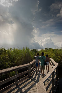
 Anhinga Trail hikers with storm cloudsI admit to feeling some degree of guilt for not giving this park the justice it deserves, but we just didn’t have the time. We already had a lot of driving to do that day to get to our reserved campsite at John Pennekamp, so stopping here was a bit forced. However, we felt we couldn’t come so close and not at least stop for a quick visit.
I think the real way to see the Everglades would be to go on a boat tour or rent a kayak and actually get out into the mangrove estuaries, but since we didn’t have time we had to settle for a Visitor Center and two short boardwalk trails.
We entered the park through the east entrance near Florida City and drove four miles to the Royal Palm Visitor Center. At the Visitor Center we did see a really wonderful film which let us vicariously tag along with a young women snorkeling through the incredible underwater wonders of the Everglades. The photography was beautiful. If we left it at that, I think we would have come away with a positive feeling about the Everglades. Instead we wandered out of the cool, bug-free Visitor Center to take on the two obligatory boardwalk trails: the Anhinga and the Gumbo Limbo. It was hot, humid, buggy, and alligator-free. We all got cranky, except for Andrew who found the Gumbo Limbo tree forest to be quite peaceful and fascinating. It’s good to know that our tuition dollars towards his Environmental Studies classes at college are having some impact.
Since visiting the Everglades, I have watched the Ken Burns documentary on the National Parks and the wonderful section he had on the struggle to save the Everglades because of its ecological uniqueness. I know it’s an amazing place, but no matter how hard I try, I still think its wonders are better viewed from the comfort of my living room couch or national park visitor center auditorium rather than the reality of its humidity and bugginess.
Description
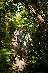
 Family hiking Gumbo Limbo TrailEverglades National Park is the 3rd largest national park in the lower 48 states, encompassing over 2500 square miles of subtropical wilderness. The park is located at the southern tip of Florida and extends from Florida Bay to Lake Okeechobee.
Unlike what most people think, it is not a swamp, but rather a 50-mile shallow river of grass that gradually flows into Florida Bay and the Gulf of Mexico. Along its 80-mile course, it drops a mere 15 feet, but just enough to keep it from becoming a swamp.
The park’s miles and miles of saw-grass prairie, junglelike hammock, and mangrove swamp make it truly unique. It is the only place of its kind in the United States. Thankfully, some forward-thinking people in the first half of the 20th century recognized its ecological value and saved it from development. It was designated a national park in 1947. Unlike other parks that were established to protect scenery, the Everglades was created to preserve an ecosystem as a wildlife habitat.
The park’s unique mix of tropical and temperate plants and animals, including over 700 plant and 300 bird species, as well as the endangered crocodile, manatee, and Florida panther, has earned it world recognition as a World Heritage Site, an International Biosphere Reserve, and a Wetland of International Importance. It is the only place in the world where alligators and crocodiles live together.
The best way to visit the park is to make the 76 miles round trip from the park entrance near Florida City to Flamingo on Florida Bay, making stops along the way to hike along the park’s boardwalk trails.
At the Royal Palm Visitor Center, just 4 miles into the park, there are two boardwalk trails:
- Anhinga Trail - a .8-mile loop offering the best opportunities to view wildlife, including alligators and birds, up close
- Gumbo Limbo Trail – a .4-mile loop through a dense tropical hardwood hammock of Gumbo Limbo trees
Other stops along the road to Flamingo include:
- Pinelands Trail -.4-mile loop through a subtropical pine forest
- Pa-hay-okee Overlook - .2-mile boardwalk to an observation deck offering a view of a vast saw-grass prairie
- Mahogany Hammock Trail - .4-mile boardwalk through a dense, jungle-like hardwood hammock
- West Lake—.4-mile boardwalk through a mangrove forest
At Flamingo, there are a variety of recreational opportunities:
- Boat tours into Florida Bay and the mangrove estuary
- Canoeing/kayaking on the Nine Mile Pond Trail or into Florida Bay
- Wildlife viewing – birds, alligators and crocodiles
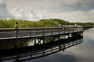
 Family hiking Anhinga TrailAnother way to see the park is to drive the 50 miles (one way) Tamiami Trail (Highway 41) along the park’s northern border. The Shark Valley Visitor Center has several short boardwalk trails as well as a 15-mile loop road accessible only on foot, bike, or on a 2-hour narrated tram ride. The Shark Valley Tram Tour provides an introduction to the freshwater Everglades as well as opportunities to view wildlife, such as alligators.
Back on the road, the Tamiami Trail veers northward into Big Cypress National Preserve, which is part of the Everglades ecosystem. At Highway 28, turn south to get to Everglades City where there are boat tours into the mangrove estuary and Ten Thousand Islands. There are also canoe and kayak rentals.
- ‹ previous
- 5 of 14
- next ›
Everglades National Park location map in "high definition"
Javascript is required to view this map.
