Anza-Borrego State Park, CA
Day 1 - Off Road to Sunset at Fonts Point

After leaving San Diego, we headed northeast for 2 hours to Borrego Springs, a small town located in the center (like a donut hole) of Anza Borrego State Park.
Herb absolutely loves deserts, and with over 600,000 acres, Anza Borrego is the largest desert state park in the U.S. Its spectacular and undeveloped Colorado Desert scenery extends from the edge of the coastal mountains east to the Salton Sea and south almost to the Mexican border.
Before leaving San Diego we had booked two nights at the Palm Canyon Hotel and RV Resort, perfectly located less than a mile from the state park Visitor Center. Although we normally love to camp in our built-out 4Runner, the February days are just too short, and the nights too cool. So instead, we like to base ourselves in a comfy hotel room, where we can stay up later than 6:00 when it gets dark, shower, use a porcelain toilet rather than a shovel, go out to dinner, swim in the pool, etc. Herb knows it makes me a happier camper, or more correctly non-camper.
.jpg)
The Resort definitely had a Wild West theme with each room fronted with a frontier town facade - a saloon, jail, dentist, mercantile, etc. We stayed in the Stage House. It was a bit kitschy, but cute and comfortable. Herb promised me that next time we could stay in either the Dentistry or the Jail. He spoils me so.
The check-in process was extremely friendly. We were given chocolate chip cookies and a coupon for 2 free drinks in the saloon. Very neighborly.
We didn’t have many daylight hours left, so we immediately headed out to watch the sunset over the Badlands from Fonts Point, considered one of the best viewpoints in the State Park. In just 15 minutes we were at the start of the 4WD dirt road to the Point, located off of S22, also known as the Borrego Salton Sea Way.
.jpg)
The road to Fonts Point is 3.9-miles and pretty easy by 4WD standards. No high clearance is needed but there are some pretty sandy spots. There’s a pretty big payoff at the end - a spectacular view of the Borrego Badlands, the Salton Sea, and the Fish Creek Mountains in the distance.
We set up our chairs, grabbed a cooler, and sipped on a glass of wine as the light changed on the Badlands below us. Herb informed me that tomorrow morning we would be driving through those very Badlands in our 4Runner. It looked very cool.
On our way back to the Stage House (our frontier name for hotel room), we stopped at Carmelita’s Mexican Grill where I had the largest Margarita of my life. Herb insisted we order the Grande size. It was like a bucket. A very enjoyable bucket though.
Day 2 - 50-mile off-road adventure (Hills of the Moon Badlands, Pumpkin Patch, 17 Palms Oasis, etc), and Sunset at Vista del Malpais
Anza Borrego has hundreds of miles of 4WD, and today we were going to try to do our best to explore a good chunk of them.
This time instead of going north to S22 (the Borrego Salton Sea Way), we headed southeast on Borrego Springs Road to Highway 78, where we quickly got off the asphalt and took a left onto Buttes Pass Road, a dirt road that most people take to get to “The Slot,” Anza-Borrego’s most popular hike.
When we got to a fork - Slot Canyon to the left, Hawk Canyon to the right – we wisely chose the less traveled right, as Slot Canyon would be packed with happy tourists, squeezing their way through the narrow passageways, especially since it was a weekend.

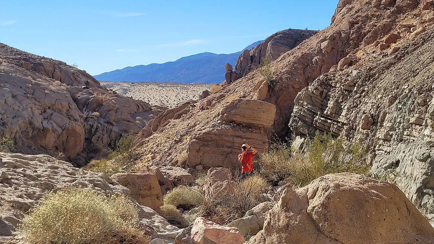
About 3 miles into our off-road journey, we made a left to take the side trip to Hawk Canyon, a fault-formed valley with sedimentary and sandstone rocks on the left (southwest side) and granitic rock on the right (northeast side). We stopped to stretch our legs and take a short, out-and–back hike into the Valley, which included some rock scrambling.
After our side trip, we drove back to Butte Pass Road, made a left, and continued about 2 miles north and then took a left on the San Felipe Wash Road. After another 2 miles we turned right on our planned higAhlight, the Hills of the Moon Wash, where we would weave our way through the Badlands that we had admired last night from Fonts Point.
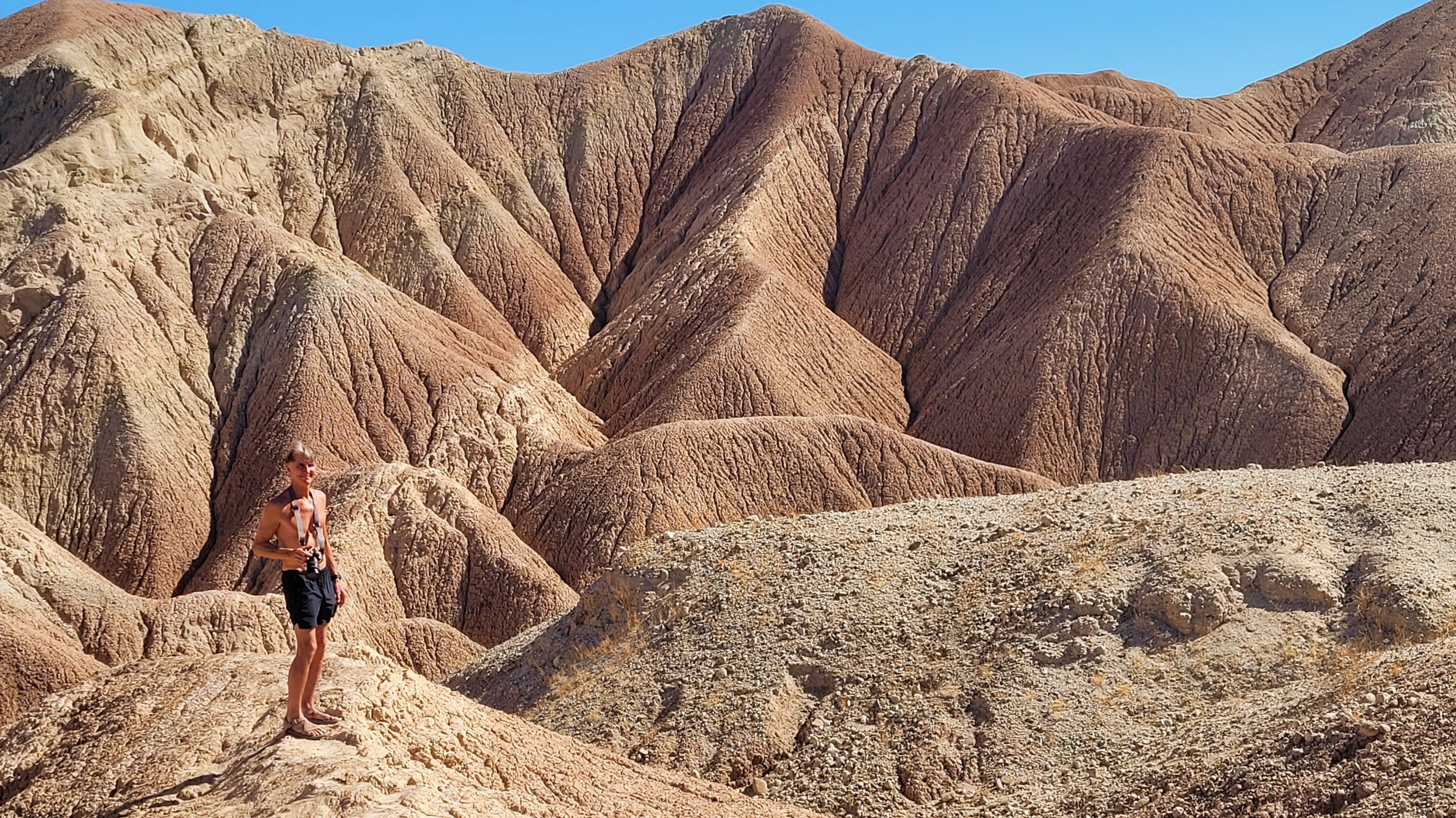
This part of our off-roading day was my favorite. It was like driving through a moonscape - a very twisty moonscape with not another soul in sight. We stopped at about 3 miles to get out and scamper up the colorful mud hills, which are completely devoid of any vegetation. There were interesting patterns in the hills, which are created by the runoff of some of the mud when it rains.
From the top of the hill, I saw that we were no longer alone. A group of 5 jeeps was heading our way. Herb quickly moved the 4Runner further off the road so that they could safely pass.
I’m not sure how much further the road went, but we decided to turn around at this point. The road is so twisty and narrow that we didn’t particularly run into a situation where we met up with the jeep squad.
We drove back from whence we came, fortunately not meeting any more jeeps along the way. Back at the junction of the Butte Pass Road and the San Felipe Wash (mile 15 since we left the pavement of Highway 38), we hung a left onto Cross Across Trail, which led northeast towards S22 where we would eventually hit asphalt again.
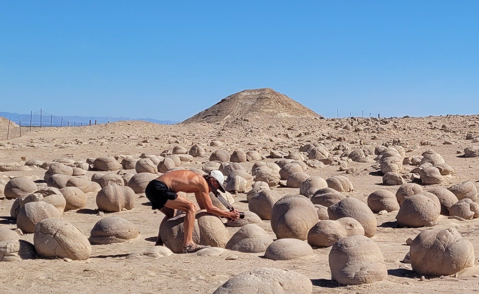
After about 6 miles on the Cross Cut Road, we hung a right onto Basin Wash Road to make a side trip to the Pumpkin Patch, a field full of spherically-shaped rocks that are all the size of an average pumpkin.

In about 6 more miles, we continued straight onto Tule Wash. At this point, we had actually left the boundaries of Anza Borrego State Park and were now in the Ocotillo Wells State Vehicular Recreation Area, where people with their dune buggies love to race up and down the dunes. The VRA area is huge, with over 85,000 acres of desert.
The parking lot for entry into the dunes was also the parking lot for the pumpkin patch. It was quite obvious that we were the only ones there planning an afternoon stroll through the pumpkin batch. The patch is really pretty bizarre, so we took the time to read the information board which explained how they were formed:
The “pumpkins” are actually a unique geologic feature called concretions, because the key ingredient to these formations is concrete. They are formed much like how a pearl forms. When loose sand becomes wet, it will naturally cement itself to a larger object such as a pebble or even an insect body. When the water evaporates, the sand becomes hardened around the object.
.jpg)
Although all concretions do not have to be round, these are. After several years of wind erosion, these concretions have slowly emerged from the sand,while remaining stationary, and have been rounded by wind. Unlike their life beneath the saand where they grew larger and larger, they are now exposed to the wind, slowly whittling away.
So, I guess than that these pumpkins are getting smaller and smaller, but nothing we will ever notice in our lifetime. Geological time works in millions of years, not summer vacations.
Our odometer showed that we had been 26 miles since we left Highway 78. Our plan was to continue on and eventually come out on S22.
.jpg)
From the Pumpkin Patch we drove north on the Tule Wash for about 4 miles before turning left (northwest) onto the Arroyo Salado Wash, where we planned to explore two fan palm oases. The Arroyo Salado is one of the hottest and driest sections of Anza Borrego, so it’s pretty amazing that these oases survive. It’s even too harsh for creosote and ocotillo.

We came to Five Palms Oasis first where we parked the truck and walked up a short ravine to the oasis set atop a ridge. Although called Five Palms, there are only four fan palms remaining. At the crest of the ridge, just beyond the palms, there is an awesome view of the Borrego Badlands and even the Salton Sea.
A few miles further, we came to the unmarked turnoff for the Seventeen Palms Oasis - thank goodness for Gaia. The information board at the edge of the parking lot was a sober reminder that this was not just an entertaining stop at the end of a day of sightseeing, but literally a lifesaver for inhabitants and travelers of the past.
From the parking area, we walked the short distance to the oasis, whose greenery stood in stark contrast to the stark and barren desert around it. I confess to counting the palms. I couldn’t help myself. It was called 17 Palms, so I wanted to make sure. There were 30 of them. Okay. I guess the oasis was doing well.
.jpg)
However, throughout the centuries the spring which feeds the oasis wasn’t always reliable, so early travelers with extra water would leave it in large glass jars in the shade of the palms for others to find. Travelers would leave notes attached to the jars.
Today that tradition lives on, but with much less serious consequences. After a short search, I found an old barrel amongst the palms, which holds a journal for current day visitors to record their own feelings and experiences at the oasis.
Besides its human history, this particular oasis is also very important to the wildlife in Anza-Borrego because it is the only year-round watering hole for many miles.
After our 17 Palms stop, we headed north on the Arroyo Salado Wash for about 2 ½ miles where we came to a junction with the Truckhaven. We took the Truckhaven Trail, but after a mile realized it was taking us too far east, and we wanted to go west, so we turned around and returned to the Salado Wash, which we took north back up to S22 (Borrego Salton Sea Way).
.jpg)
We drove on the pavement for 3 miles and then turned left onto the 4WD Thimble Trail with the intention of watching sunset at Vista del Malpais. We drove 2 miles south on the Thimble Trail and then turned left (east) onto Short Wash. There was one steep, rutty section on Short Wash, but nothing too difficult for the 4Runner to handle. After 1.3 miles we turned right on Vista Road and drove another 1.1 miles to the parking lot.
Not far as the crow flies from Fonts Point, Vista del Malpais is the lesser known of the two best viewpoints in Anza Borrego. They both overlook the Borrego Badlands, but Fonts Point has a higher vantage point. However, I actually like Vista del Malpais better because it is quieter and has a better 360 view of the badlands.
.jpeg)
So once again, we set up chairs and watched the sunset over the Badlands we had been playing in all day. Hard to believe we had driven through that!
We had a long day - close to 50 miles of off-road exploring, so we thought we would just stay home and have dinner at the Big Horn Burgers and Shakes, right in our hotel. How could we pass up a place that advertised itself as the “Best Beef Wranglers and Booze Clerks” in Borrego Springs.
Ordering was easy. The only menu option was hamburgers, which turned out to be very good. We also used our coupon for two free drinks at the saloon, and I was pleased that they had a very good Chardonnay from our home county of Sonoma.
Time to hit the hay! Another big day tomorrow.
Day 3 - Off Road to Calcite Mine, hiking through two slot canyons, and seeing the Galleta Meadow sculptures

There was one 4WD road that we didn’t have time to do yesterday, so we decided to add a third night to our stay in Borrego Springs so that we could. Actually, there are a lot of 4WD roads in Anza Borrego that we would like to do, but that would have to wait until a future trip.
This morning’s adventure would be a drive up Calcite Canyon to an old mine and two slot canyons. The turnoff for Calcite Mine road is located on S22 (Borrego Salton Sea Way), just east of the Salton View turnout (mile 38) and west of the Microwave Tower (mile 39).
The drive, which is graded as difficult (but really wasn’t) immediately drops steeply down the sandstone cliffs into the South Fork Palm Wash.
Rather than take the left into the Palm Wash, where there is an arch and a slot canyon, we decided to go straight right on the Calcite Mine trail right past the yellow ROUGH ROAD sign - because apparently we are bad ass.
At 1.4 miles, we pulled off to the left in a parking spot that could fit two cars. This was the trailhead for the hike into the Calcite Slot Canyon.
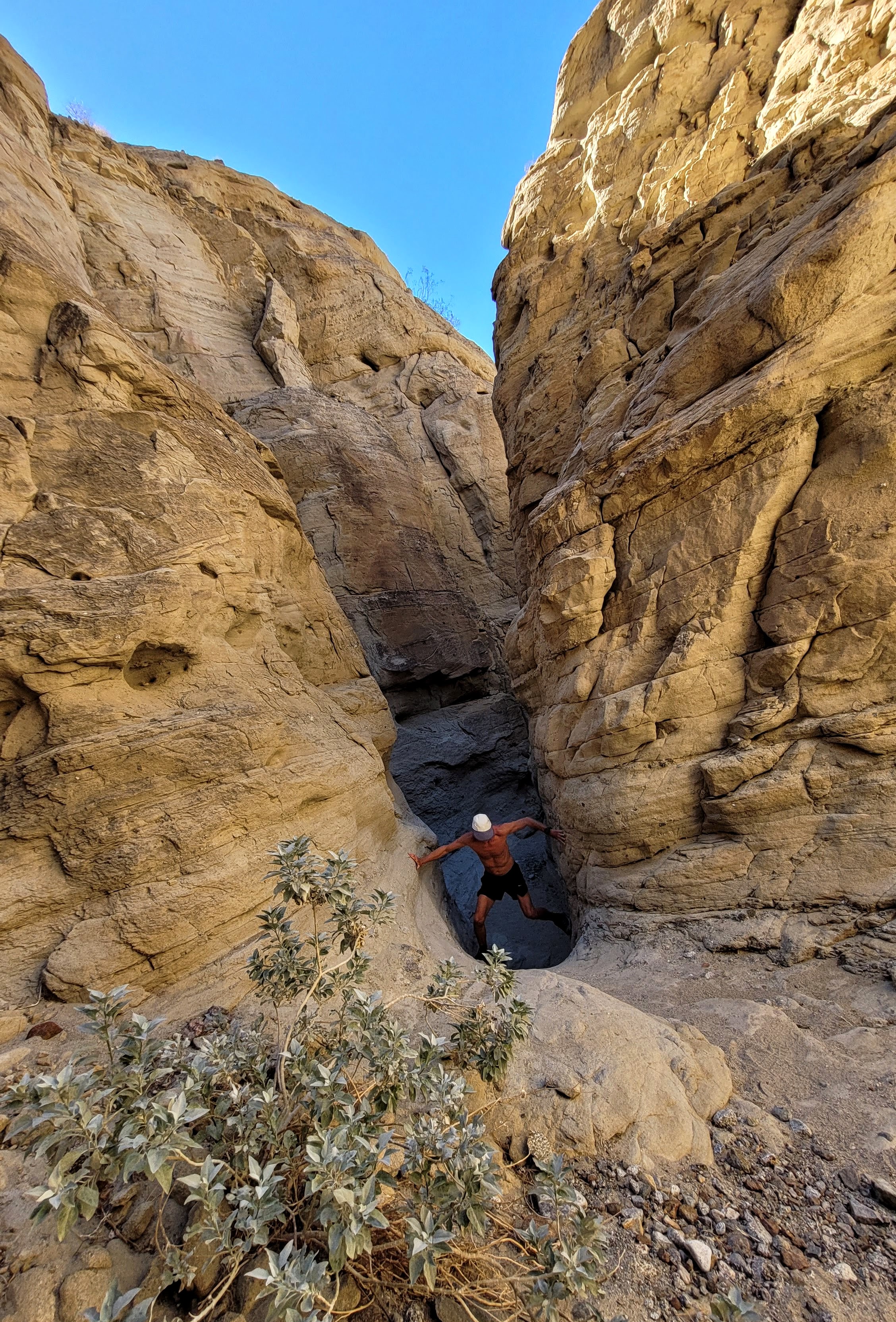
A short walk from our car through a wash soon brought us into the smooth white, sculpted wavy walls of the Calcite slot canyon, considered to be one of the best slot canyons in California.
This slot canyon is different from others in Anza Borrego, in that its walls are smoother than the rough, corrugated walls of other canyons, such as The Slot, and is comprised more of tougher sandstone than the loose layers of dry mud often found in wash canyons.

For a half mile, we squeezed through the canyon, climbing over rocks, sliding down ramps, and just generally enjoying ourselves the entire way. It was beautiful and so much fun.
After about a half mile, we came to a ten-foot dry falls, which we figured was the end of the road. We turned around here and headed back, not realizing that a few hundred yards back there is a gap on the east wall through which you can exit the canyon and continue on foot to the Calcite Mine. Instead we returned to our 4Runner, and drove the ½-mile steep, rough road to the Mine.
Although this was an old mining site, there were no structures or equipment left behind to identify it as such. I didn’t even know what calcite was, but I later learned that this mine had a rich deposit of high-grade optical calcite that was used during World War II in the manufacture of precision bomb sights. However, a less expensive, synthetic substitute was soon created that had the same optical qualities as the calcite, so the mine was soon abandoned.
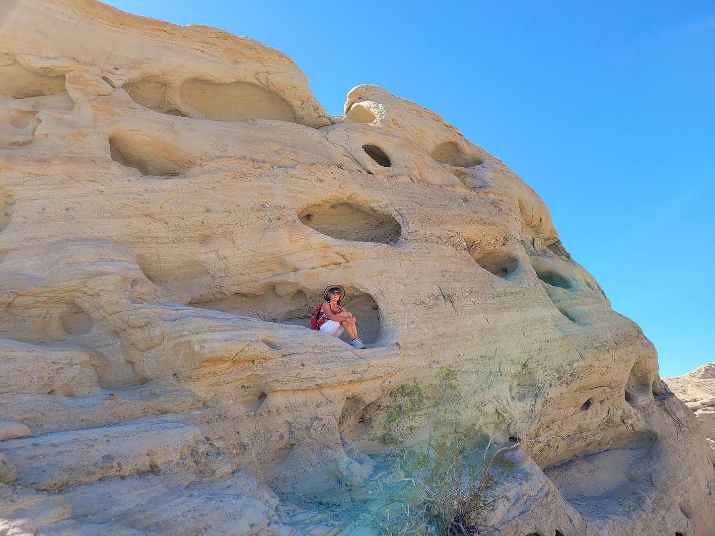
Footpaths leave the Calcite Mine in several directions, but we first took the one that led to a sandstone formation with wind-eroded pockets in them, some of them large enough to sit in - so I did!
These pockets are called wind caves (or aeolian caves), because they were formed by the forces of wind, which sculptured the rock with sand like a sandblast. However, since the interior of the caves tends to be windless, they are usually not very deep.
The next path we followed was the one that led to the top of an 1,122-foot high hill with even better views of the badlands and the Salton Sea.

This was the end of the road, so we retraced our steps and drove the 2-miles down the rocky, steep Calcite Mine Road to the turnoff for the South Fork Palm Wash, just shy of S22, and took a right and followed the wash for about a ½ mile to the end of the vehicle-accessible portion.
From there we set out on foot. In about 200 yards we reached a small arch over the path and then in another 200 yards or so, we entered another slot canyon.
Unlike the smooth walls of the Calcite slot canyon, this one was rougher with conglomerate rocks embedded in its walls. In about a ½ mile we came to a 20-foot dryfall which blocked our progress, so we turned back and headed towards our car.
We did meet some people that were planning to do this hike all the way up to the Calcite Mine through the Calcite slot canyon. So, somewhere shy of the drywall there must have been a gap in the wall that we didn’t see that would allow you to exit the slot canyon and continue up a trail to the Calcite Slot and eventually the Calcite Mine.

If you only have a 2WD vehicle or a 4WD without high clearance, parking in the lot on S22 and hiking is the only way to explore the slots and the mine. I think it is about a 4 or 5 mile hike and definitely not a bad option for exploring this fascinating area.
We headed back to the Palm Canyon Resort and spent some well-needed pool and hot tub time. It was pretty funny sitting in a hot tub surrounded by a Wild West frontier town - kitschy but well done.
There was one more thing I wanted to do in Borrego Springs before leaving the next morning, and that was exploring Galleta Meadows where there are dozens of bizarre metal sculptures, somewhat randomly popping out of the desert landscape. We had seen many of these sculptures on a previous visit, but they are definitely worth seeing again.

They are the work of an artist named Ricardo Breceda, who was commissioned in 2008 by Dennis Avery, the owner of the Galleta Meadows Estate, to create a collection of prehistoric creations on his three square miles of undeveloped land in Borrego Springs. Since then, the collection has grown to over 130 sculptures, including human figures, like a gold miner, along with contemporary animals, such as big horn sheep, elephants, tortoises, horses, and more.
We had lingered too long in the hot tub, almost blowing seeing these sculptures in daylight, so we immediately headed out to our favorite one - a 15-foot scorpion waging battle with an equally large grasshopper. The detail was amazing.
I got out to take a picture, but soon got annoyed with Herb for driving into my carefully composed photo. However, I quickly realized this was “the money shot”. Herb and his beloved 4Runner breaking up an epic battle between a giant scorpion and a grasshopper.
.jpg)
Next, we stopped to say hello to the Sea Dragon, a 350-foot long sea serpent whose body submerges and emerges from the ground. It even crossed the road. It has the head of a dragon and the tail of a rattlesnake. You have to see it to believe it.
My other favorite capture was a series of two photos documenting Herb’s encounter with some sort of fierce prehistoric dinosaur. While at first, the dinosaur seemed to be in command of the situation, it was later subdued by my “alpha male” husband.
You can spend a whole day exploring these unique sculptures, but unfortunately we had run out of daylight.
We finished off our day, and our stay in Borrego Springs, with a pre-Valentine’s Day dinner at the Red Ocotillo, a highly-rated Borrego Springs organic garden-to-table restaurant with a lovely outdoor patio, and generous dishes prepared with only the finest fresh ingredients.
Tomorrow morning we would head towards Joshua Tree National Park with a few stops along the way.