Olympic National Park, WA
Olympic National Park encompasses over 1,400 square miles of the Olympic Peninsula in northwest Washington State. It is a land of tremendous variety with several distinct ecosystems: glacier-covered mountains, 60 miles of rugged Pacific coastline, a lush temperate rain forest, and subalpine meadows full of wildflowers. The western slopes of the mountains receive more than 200 inches a year of precipitation, giving it the distinction of being the wettest climate in the Continental U.S.
There is no road that runs through the entire park. While US 101 goes through a few sections of the park, access is mostly from spur roads that lead from US 101 into such areas as Hurricane Ridge, Sole Duc, the Hoh Rain Forest, and Rialto Beach.
Lake Quinault and the Quinault Rainforest

Since we were approaching the Park on US 101 from the south, the first section of the National Park we came to was Lake Quinault and the Quinault Rainforest - one of the few parts of the park we hadn’t seen on previous visits.
The lake was lovely, surrounded by steep mountains and a rainforest near its southern shore. The Quinault Rainforest is one of the three major rainforests on the Olympic Peninsula, receiving 167 inches of rain a year. Today was the only rainy day forecasted so far on our trip, but what better place to spend it than in a rainforest.
There is a popular 0.6-mile Rainforest Trail, but we wanted to do the more ambitious 5-mile Quinault Loop National Recreation Trail, which started up the road a bit across from the USFS Ranger Station.

From there we entered a lush forest of huge Douglas firs, Sitka spruce, western hemlock and red-cedar, with lots of ferns and mosses. There were interpretive signs along the way explaining the ecology of the forest. We saw only 2 or 3 people the whole way.
Eventually we came to a junction, which allowed us to continue onto the shorter and therefore more popular Rainforest Trail which led us through a stand of 500-year-old Douglas Firs.
We continued through a tunnel which went under the road towards Willaby Campground and a view of Willaby Falls from a wooden bridge. However, to really see the falls you had to clamber a few yards off trail by the bridge to get a full, unobstructed view of the falls.
From there we walked along the shore of Lake Quinault, eventually coming to the lawn of the historic rustic Lake Quinault Lodge, a very impressive structure that would have been an awesome place to stay. Not exactly cheap though. When I was researching places to stay in the area, I saw that their rooms were around $400 a night and they weren’t even available. Instead we would be lodging at site D011 in the Kalaloch Campground for $13.
The irony was, it didn’t rain a drop our entire time in the Rainforest.
Kalaloch

However, as we continued our drive up US 101 to Kalaloch, it did start to rain, and not just a drizzle, but a good steady rain. Camping in the back of a 4Runner in the rain is not the greatest experience, so I certainly hoped that the forecast was correct and that it would clear up by mid-afternoon.
The rain did pretty much stop when forecasted, but since there was no real need to check into our campground except to sleep, we decided to explore some of the beaches recommended for their tremendous scenery..
Over the next few days we would try to explore the most beautiful beaches along the Olympic coast. Each of them shared the classic Olympic Peninsula traits - broad and sandy with much driftwood washed ashore, and rock outcroppings, called seas stacks, eerily rising from the sea. Despite that, each of them had their own distinct feel and beauty.

We got most of our ideas from our Photographing Washington book, a series that shows the most stunning natural scenery in each of the western states. You don’t have to be a photographer to enjoy spending time on a beautiful beach.
Today, we found time to stroll along three of them.
First up, the rather uncreatively-named Beach 4, just a 3-mile drive north of the Kalaloch Campground. The parking lot was practically full, which was something we would encounter at every beach and trailhead in the park. Since Covid and the discovery by so many Americans that nature is really pretty cool, the national parks have exploded in terms of number of visitors.

We had been to this beach before, in another lifetime back in 2001 when we had gone on a ranger-led guided tour of the tide pools, with our then 10-and 12-year old sons.
This beach, which has been designated a marine wildlife preserve, is known as being one of the best locations in Olympic National Park for exploring the pools..
When we got to the trailhead, we checked the tide chart and found out that unfortunately this week the negative low tides, when the pools are exposed and best visited, occurred at ungodly hours in the middle of the night. So no tide pools for us this visit.

You can’t have it all. After all, we did hit Bandon Beach earlier this week at the absolute best timing in terms of tides.
Still, the beach was very beautiful and very much worth the stroll along its rocky shores.
We continued another 5 miles up US 101 to another one of Olympic’s gems, Ruby Beach. This one was so crowded that we had to wait for a parking space.
The 1/4-mile trail down to the beach was steep with good view points of the beach and their signature sea stacks along the way. Unlike some of the other beaches, this one was mostly cobblestones rather than sand.
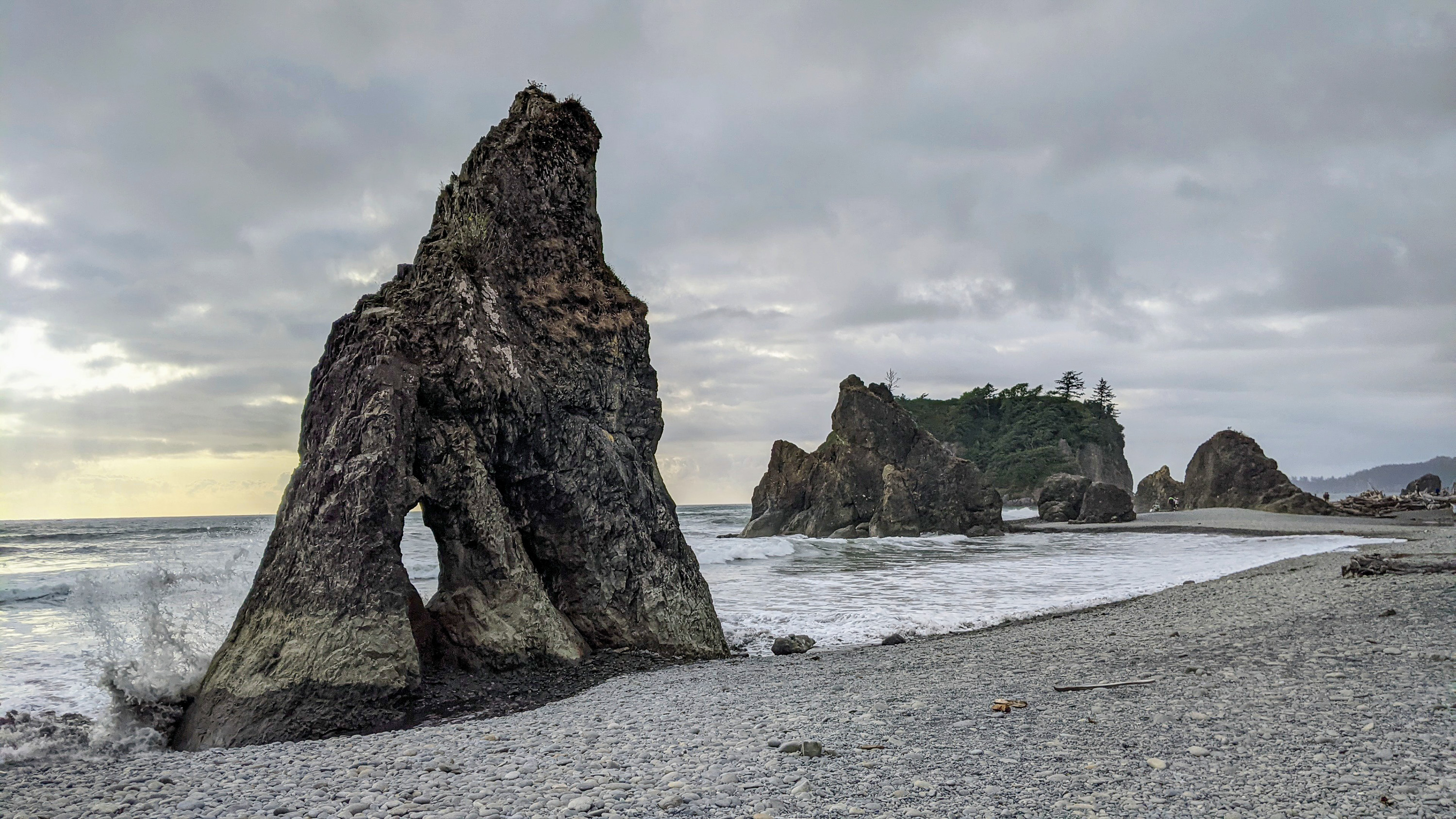
There were several interesting sea stacks to admire, including one with two holes that served up all kinds of photographic opportunities. I imagine there is a line up of people during the evening to capture sunset through it.
Also, Cedar Creek ran alongside the beach a bit before flowing into the Ocean providing kids with a fun, safe place to play in the water. Herb and I set our backpacks up against a large driftwood log near the Creek and sat for awhile just enjoying the surroundings.
Our final beach of the day was Kalaloch Beach right from our campground - not too shabby either.

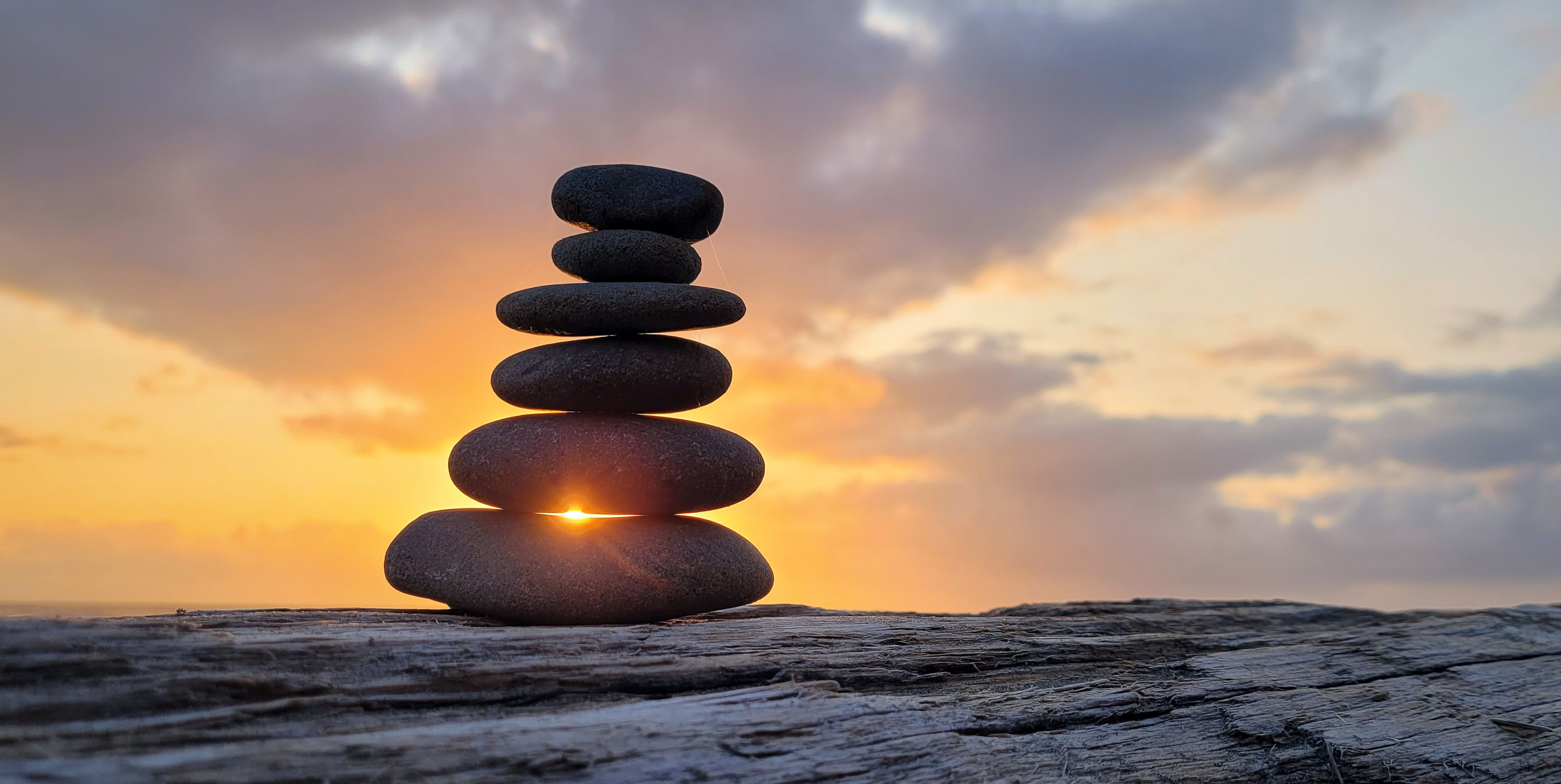
We didn’t go far that night as our main goal was to sit on a driftwood log, sipping wine, and watch the sun set. It didn't disappoint.
There was a cute little cairn on our log, which made for interesting photos of sun rays seeping through the gaps between its individual stones.
Tomorrow we would be moving for 2 nights into one of the rustic cabins atop the bluff further down the beach. I was very excited.
Since we couldn’t check into our cabin until 4:00, we had the whole day to explore. After another walk on “our” beach, we headed north with the intention of visiting the Hoh Rainforest. After driving about 20 miles north on US 101, we turned onto the Upper Hoh Road where it was another 18 miles to the Hoh Rainforest Visitor Center.
Still quite a bit before the Olympic National Park Entrance kiosk, traffic came to a stop and we noticed a sign that said 45 minute wait. Cars would only be allowed in as other cars left. You’ve got to be kidding me. This was the same thing we encountered in Utah when trying to get into Arches National Park. Since Covid, the national park are being overrun with visitors in numbers they have never seen before.

Oh well. We had been to the Hoh Rainforest before and we had just hike in the Quinault Rainforest yesterday, so we decided to make a U-Turn and visit another beach on our list instead..
After returning to US 101, we continued north through the town of Forks where we then made a left and headed west on WA-110. When we came to the fork with Mora Road, we had to make the decision - Rialto Beach to the right, 2nd Beach to the left. They both were on our list of most beautiful beaches.
Maybe we can do both today, I said. Well, we had to start with one, so we sort of randomly chose Rialto Beach maybe because 2nd Beach wasn’t as inspiringly named.

At the end of Mora Road, we came to yet another full trailhead parking lot, but fortunately we didn’t have to wait long for someone to pull out.
I think this was my favorite of the sea stack beaches on the Olympic Peninsula - my overall favorite has to be Bandon Beach in Oregon. Everything seemed a bit more dramatic - the crashing waves, the interesting, upright dead tree that looked like it was reaching out to the sea, and the sea stacks themselves.
The best part of all was that there is a natural arch on a rocky outcropping 1.5 miles down the beach called Hole-In-The-Wall. It looked a bit precarious to get to as you had to clamber over rocks to get to it. The high road was drier but required a bit of minor rock climbing and the lower route was slippery and you were sure to get your feet wet.

We watched people do this for awhile to make sure we wanted to do this, but when I saw enough people a lot less athletic than me, I told Herb let’s go for it. I did take the lower route where I couldn’t fall very far, but did get my sneakers soaked. Herb took the lower route as well, but somehow managed to stay drive.
Safely around the corner, we walked through the arch to an area that would be really cool in terms of tide pools if the tide was lower. Still, we did get to see several anemones.

The tide was coming in, so we didn’t want to wait too long to make our way back from whence we came. It was easier on the way back, because my sneakers were already so wet that I didn't care about stepping in the water.
It was already 3:00, and I was pretty excited about checking into our cozy rustic cabin, so we decided to save 2nd Beach for another day.
We had stayed in these cabins in 1990, when we brought Andrew here as a one-year-old, so these cabins had a very nostalgic place in our hearts. However, this time would be a lot more quiet and peaceful.

I was a little disappointed that we got the cabin on the very end, where there were trees obstructing our view of the ocean a bit, but it was still very nice. Rather than getting take-out food tonight at the Lodge, we decided to cook one of our backpacking meals on the patio, watching a lovely sunset through the trees.
After sunset, I convinced Herb that he really wanted to make a fire in the cabin’s wood burning stove. All the fixings were there - logs, kindling, and even a starter block. So, we set up our camping chairs in front of the stove and spent a cozy evening sipping wine before the fire.
Since we had the cabin for two nights, we decided to spend the entire day in the Kalaloch area.

We started off the morning with an invigorating 5-mile run along the beach. I usually hate running on sand, but the sand on this beach was hard enough to make it fun. We did have to take our sneakers off to cross the Kalaloch Creek which flows into the ocean right by the lodge. It was so much fun.
After that we went over to the Kalaloch Lodge to enjoy lunch on their outdoor patio overlooking the Kalaloch Creek we had crossed earlier that morning. The food was good and the view was wonderful.

Later that afternoon, we went for another stroll (and stream crossing) along the Kalaloch Beach. One of the most interesting features we discovered along the way was the Tree of Life (aka Tree Root Cave), a large sitka spruce on the edge of the bluff with its roots totally exposed, hanging onto nothing but air.
Somehow this amazing tree has managed to survive, despite having no soil or roots to anchor it in place. The tree seems to defy nature and the frequent storms that topple trees more firmly anchored in the soil.

Magic? Probably not, but that doesn’t stop beach strollers from paying homage to it - taking photos standing beneath its exposed roots. Of course, we had to do the same.
Another evening, another beautiful sunset and a cozy fire in our cabin.
It had been a lovely stop in Kalaloch, but we weren’t quite done with Olympic National Park yet. I had managed to get a campsite in the Sol Duc Hot Springs Campground, a section of the Park that we had never been to before.
On the way to Sol Duc, we decided to do a side trip to 2nd Beach, the last on my list of best beaches in Olympic National Park. So, when we got to Forks, rather than continuing on US 101, we once again made the turn onto WA-110, but this time we took it all the ways to its end rather than turning right on Mora Road towards Rialto Beach.

We headed out on the 2nd Beach trail which took us through a lush, dense forest before leading us out onto another sandy beach with a rocky headland to the north and a large,tree-topped sea stack just offshore.
It was quite overcast as we strolled up the beach, but with the exception of 2 hours of drizzle a few days ago, we had managed to avoid being rained on during our entire trip.
Sol Duc Hot Springs

Back in the car we continued on US 101 towards the Sol Duc Hot Springs resort where we had a campground reservation for that night. This resort is the most commercially developed area in Olympic National Park. Since 1912, tourists have been coming here to experience the medicinal healing of the hot springs.
Although we planned to partake in a hot spring soak later in the day, our first order of business was a hike to Sol Duc Falls. Conveniently, the trailhead for the hike was right from our campground.
We left the campground and entered a lovely forest of towering conifers and maples draped in Spanish moss. Not another soul was to be seen until our campground trail converged with the one starting at the major trailhead.
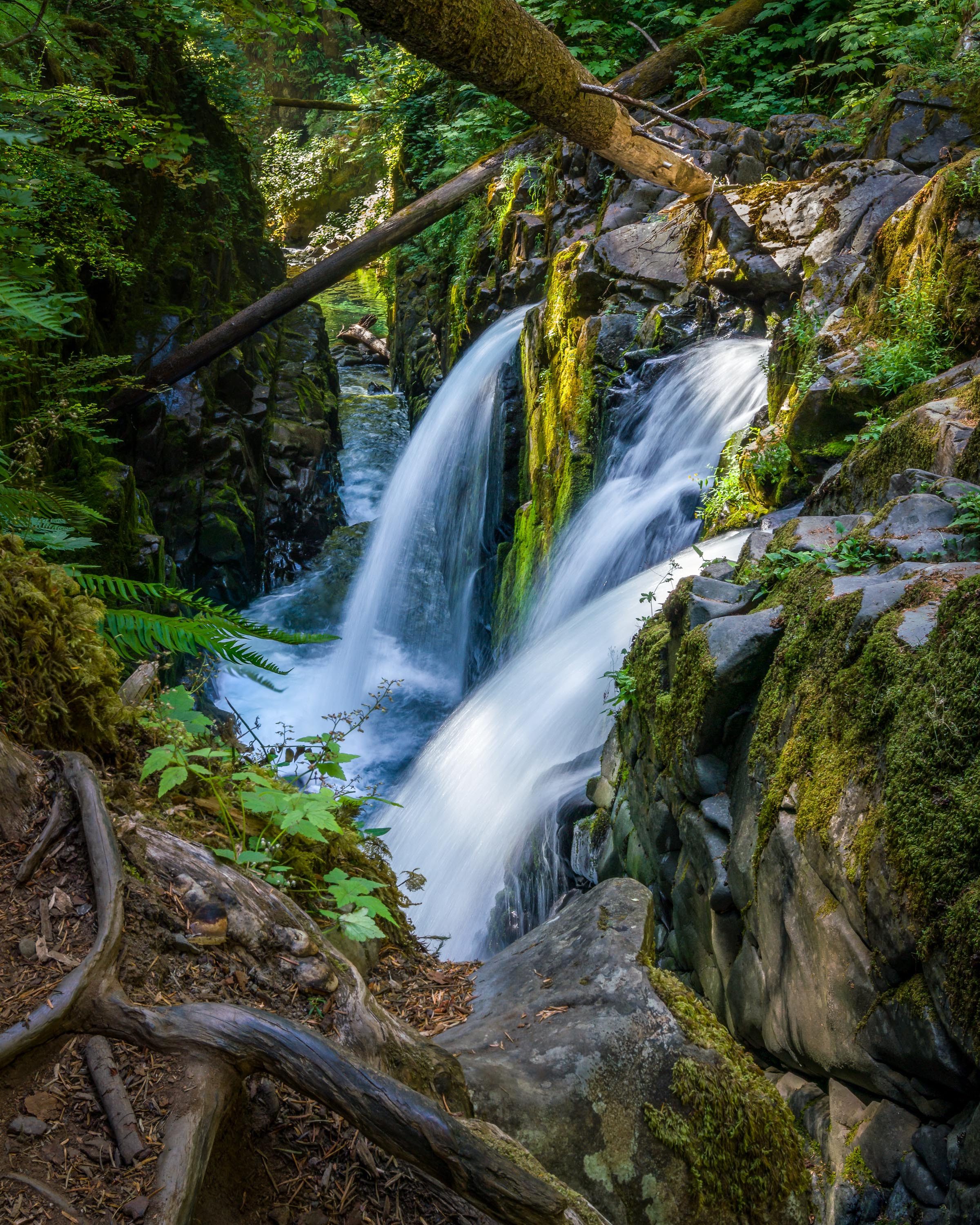
At a little over 2 miles we came to a wooden footbridge over a deep gorge, just 50 yards downstream from where the Sol Duc Falls cascades 50 feet before rushing through the narrow chasm under the bridge.
Wow! With the terrible drought in California this summer, we weren’t used to seeing and hearing water rushing anywhere. It was so refreshingly beautiful and all the vegetation around it was so green and lush..
Although the view from the bridge was good, we found a much better vantage point beyond the bridge by scrambling over some rocks to get down lower to the pool below the falls.
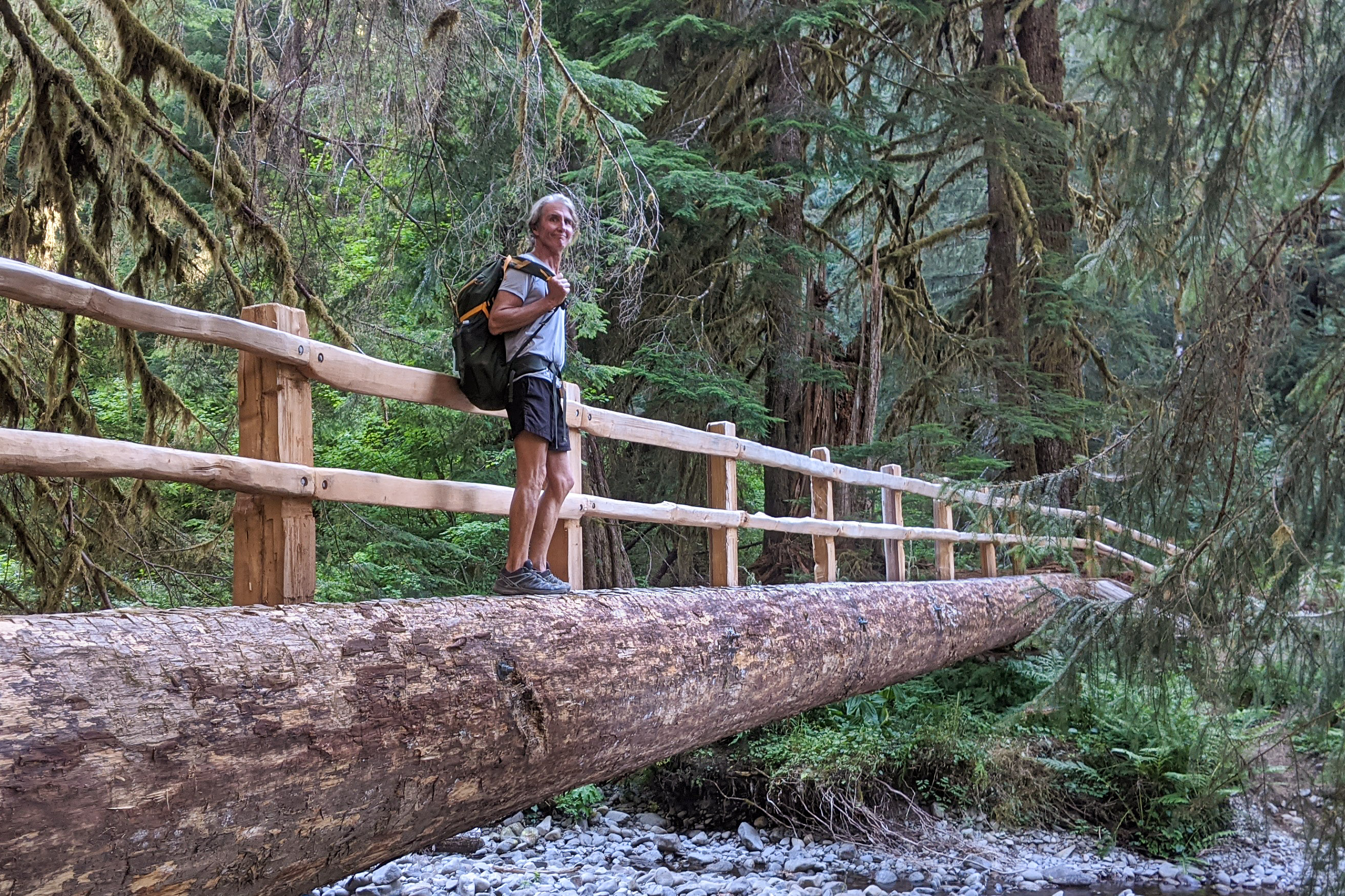
While most people headed back along the trail we hiked in on, we continued on to the recommended Lover’s Lane trail. At first I didn’t like the trail, as it was rocky, unlike the soft pine needle covered trail on the way in. However, it got easier and more interesting and we crossed three footbridges made from huge cut logs, with wooden rails on only one side.
After about 5.5 miles we reached the Sol Duc Hot Springs Resort, where we planned to take a soak, but first we needed to get back to the campground, which was one mile further, to retrieve our bathing suits and towels.
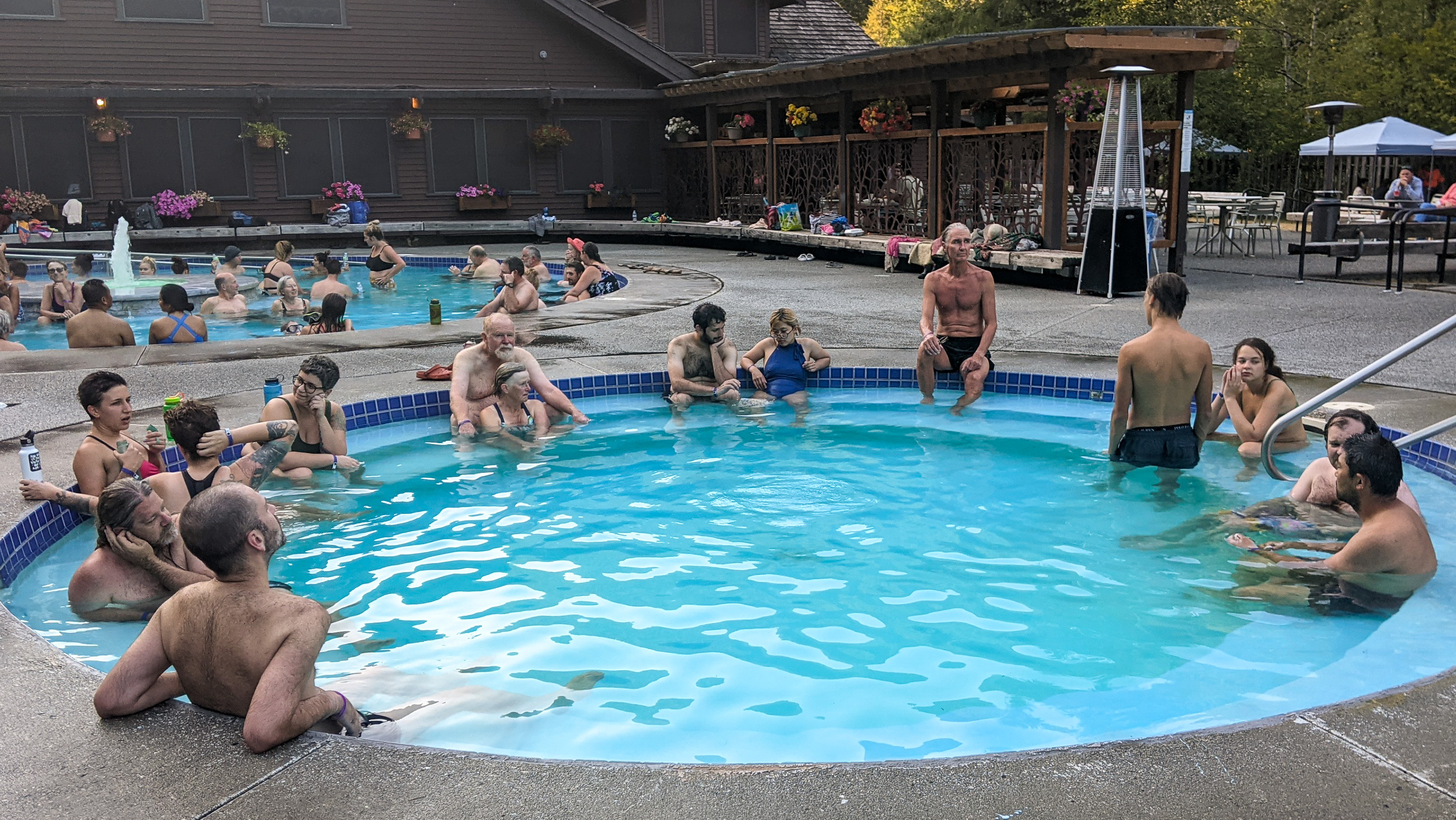
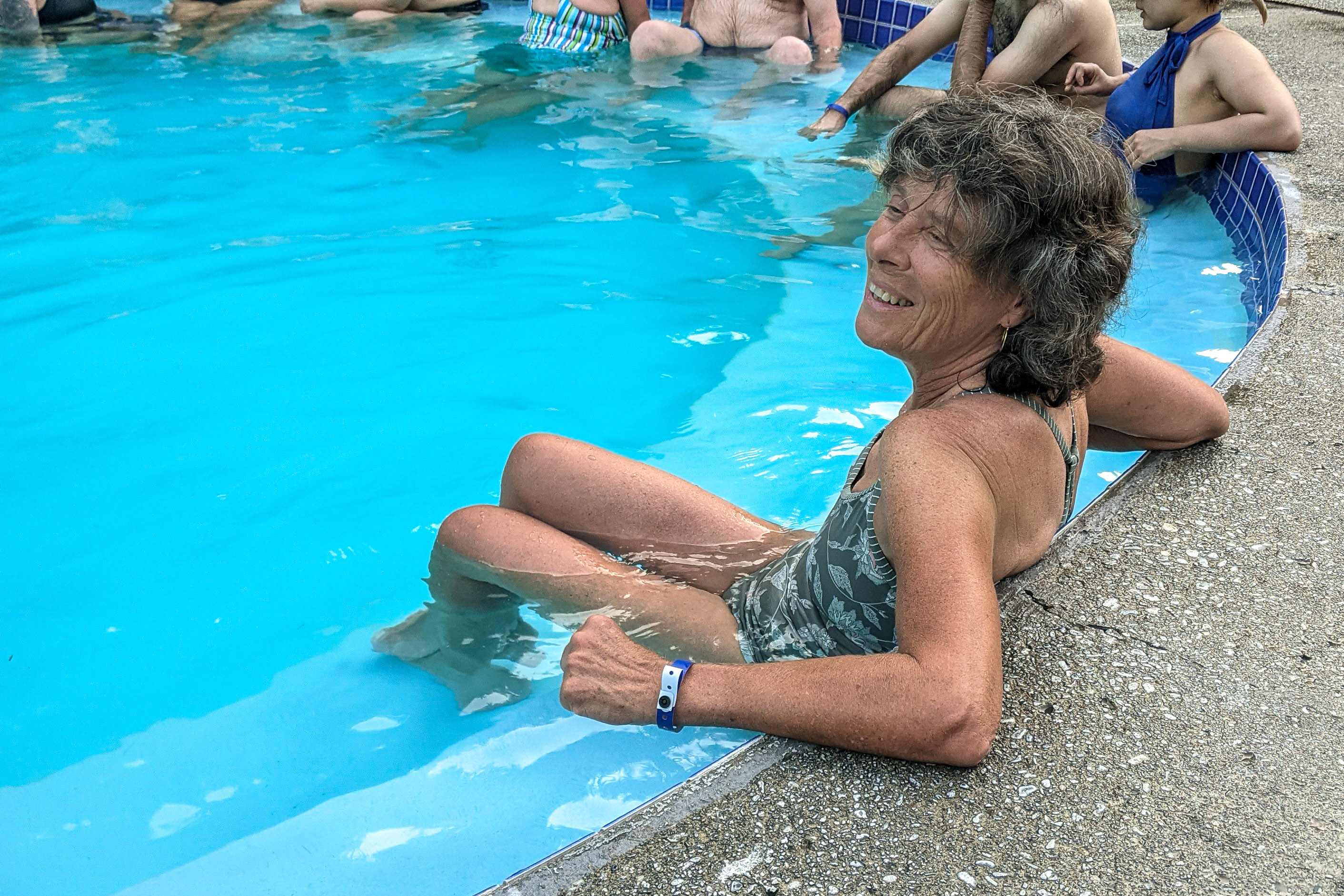
We drove back to the resort for the 6:00 - 7:30 soaking session. Prices for adults (12+) are $15, but only $12 for Seniors (62+).
There are three mineral hot spring soaking pools to choose from and one freshwater pool. The small mineral pool is 99°, the medium 104°, and the large one 101°.
We choses to spend an enjoyable hour in the 101 degree one. Even that one was hot enough to make us switch back and forth between soaking and sitting along the pool’s edge, and a dip in the 85° freshwater one.
The next morning we left Sol Duc Hot Springs with the intention of hiking along Hurricane Ridge, the mountainous part of Olympic, but the clouds and threat of rain were definitely not going to be conducive to a hike known for its spectacular view.
Still we had had a wonderful time in Olympic - visiting some old favorites and seeing some new.
Time to head towards home, but a quick look at the smoky conditions in the West pretty much shut down any thoughts of further outdoor activity. We hopped on I5 and headed south.