- Home
- About
- Map
- Trips
- Bringing Boat West
- Migration West
- Solo Motorcycle Ride
- Final Family XC Trip
- Colorado Rockies
- Graduates' XC Trip
- Yosemite & Nevada
- Colorado & Utah
- Best of Utah
- Southern Loop
- Pacific Northwest
- Northern Loop
- Los Angeles to NYC
- East Coast Trips
- Martha's Vineyard
- 1 Week in Quebec
- Southeast Coast
- NH Backpacking
- Martha's Vineyard
- Canadian Maritimes
- Ocracoke Island
- Edisto Island
- First Landing '02
- Hunting Island '02
- Stowe in Winter
- Hunting Island '01
- Lake Placid
- Chesapeake
- Provincetown
- Hunting Island '00
- Acadia in Winter
- Boston Suburbs
- Niagara Falls
- First Landing '99
- Cape Hatteras
- West Coast Trips
- Burning Man
- Utah Off-Roading
- Maui
- Mojave 4WD Course
- Colorado River Rafting
- Bishop & Death Valley
- Kauai
- Yosemite Fall
- Utah Off-Road
- Lost Coast
- Yosemite Valley
- Arizona and New Mexico
- Pescadero & Capitola
- Bishop & Death Valley
- San Diego, Anza Borrego, Joshua Tree
- Carmel
- Death Valley in Fall
- Yosemite in the Fall
- Pacific Northwest
- Utah Off-Roading
- Southern CA Deserts
- Yosemite & Covid
- Lake Powell Covid
- Eastern Sierra & Covid
- Bishop & Death Valley
- Central & SE Oregon
- Mojave Road
- Eastern Sierra
- Trinity Alps
- Tuolumne Meadows
- Lake Powell Boating
- Eastern Sierra
- Yosemite Winter
- Hawaii
- 4WD Eastern Sierra
- 4WD Death Valley +
- Southern CA Deserts
- Christmas in Tahoe
- Yosemite & Pinnacles
- Totality
- Yosemite & Sierra
- Yosemite Christmas
- Yosemite, San Diego
- Yosemite & North CA
- Seattle to Sierra
- Southwest Deserts
- Yosemite & Sierra
- Pacific Northwest
- Yosemite & South CA
- Pacific Northwest
- Northern California
- Southern Alaska
- Vancouver Island
- International Trips
- Index
- Tips
- Books
- Photos/Videos
- Search
- Contact
Seattle, WA
Thursday, May 29, 2014 - 6:15am by Lolo
228 miles and 4.5 hours from our last stop - 4 night stay
Travelogue
 Approaching Gas Works Park via KayakVisiting a city with a motorhome is always a challenge, so finding the proper campground to use as a base camp for Seattle has been a work in progress for us. On our first visit, we stayed at Saltwater State Park, a lovely campground with a beach right on Puget Sound, about 23 miles south of the University District where Tommy lives. However, I5 can be a nightmare in terms of traffic, with a morning rush hour that lasts practically overlaps the afternoon one.
On our next visit we stayed at the Seattle Tacoma KOA, about 4 miles closer to Seattle. Although the setting is not as nice as Saltwater State Park, it does have the amenities that Saltwater does not, such as hookups, a pool, and laundry.
This year, thanks to the Moon West Coast RV Camping book that I have come to depend on, we found a new option: the Vasa Park Resort, right on lovely Lake Sammamish in Bellevue, Washington, just 7 miles from Tommy’s office in Redmond. It pretty much had it all – convenient location, beautiful setting, hookups, and a laundry. It’s really small though and fills up on weekends. There are 16 campsites, 6 full hookups and 10 partial. Fortunately, I had made a reservation in advance for one of the partial sites.
 Lake Union HouseboatThat night we just hung out at the campsite and barbecued salmon. It was really pleasant, with great views of the lake, which was only about a 100 yards from our campsite. It was hard to believe that this place was so close to the city. Tommy was considering moving here and living in a tent, so he wouldn’t have to contend with rush hour traffic from Seattle to Redmond every morning.
For the next day’s activities, I had really pushed for (and won) a kayak trip. Herb and my kayaks were spending far too much time just riding up and down the West Coast on the roof of the motorhome, so getting them out on the water was far overdue. Also, Seattle has so much beautiful water surrounding it that it would be the perfect place to exercise them.
Although Puget Sound would have been our first choice, the forecast was for strong winds, making the more protected Lake Union a better option.
 Andrew and Tommy in Synchronized Water Tube SlidesWe got a very good deal on kayak rentals for the boys at Moss Bay on Lake Union’s southeastern shore. On weekdays, if you rent for two hours, you get the next two hours free. The hourly rate was only $14, so each kayak was only $28 for 4 hours – not bad at all.
Lake Union is part of the Lake Washington Ship Canal System, so you can go west out through the locks to Puget Sound or east through Portage Bay and Union Bay into Lake Washington. However, those are really long trips, meant more for a powerboat or a multi-day kayak trip. We would content ourselves with exploring Lake Union.
We started off along the eastern shore of the lake, past the houseboats popularized in the movie Sleepless in Seattle. One of my favorite activities is peeking in windows of cozy homes, so this was a great opportunity for me, especially since most of these homes were mostly windows to take advantage of the great views of the city.
 Tommy Leading on World War I Wall at Exit 32After admiring the floating homes, we paddled over to Gas Works Park, the site of an old Seattle Gas Light Company gasification plant that has been transformed into a public park. Much of the old plant’s rusty towers, tanks, and pipes remain and make for a very interesting landmark on the lake – a sort of industrial still life. We had hoped to beach our kayaks and have lunch, but there were numerous signs forbidding it due to sediment toxicity surrounding the plant.
Undaunted, we continued on through Portage Bay and into the narrow Montlake Cut, which is the University of Washington’s crew team’s home course. The walls alongside the cut were covered with inspirational graffiti, extolling the superiority of the Huskies, and urging rowers to push harder to the finish line. It even got me to paddle a little faster.
 Andrew Leading on World War I Wall at Exit 32Our turnaround point and lunch spot was at the entrance to Union Bay at the Washington Park Arboretum, a 230-acre botanical garden that is managed jointly by the University of Washington and the City of Seattle. It would have been nice if we could have left the kayaks and explored the park a bit, but Tommy suggested that we come back by car on another day. Instead, we sat on a picnic table at the water’s edge and ate our lunch. It was a lovely spot.
The way back was a bit tougher – the winds were picking up as forecasted and the water was getting a bit choppy. As we got back into Lake Union, we were treated to wonderful views of the city and the Space Needle, which had been behind us on our way out.
I was falling a bit behind as we were finishing our paddle, so I missed most of the rescue operation that Herb and Andrew got themselves involved in. Tommy had stayed behind with me to make sure that I was okay and wouldn’t require my own personal rescue.
As Herb describes it, as they were approaching Moss Bay, they saw a kayaker struggling to get back into his capsized kayak. Often people like to get out of their own messes, especially if they are experienced, so they were unsure at first whether he wanted their help. As they approached him, they saw his hand rise above the kayak and the word “Help” coming from his direction. I guess that was about as clear as it gets.
 Hiking the Little Si TrailHerb came up alongside him and tried to hold his kayak in place while he climbed back in. After several failed attempts, they reverted to plan B. The capsized kayaker climbed onto the dock with his river bag, while Herb towed his kayak back to the rental dock, which was only about 100 yards away. That’s right, he had only gotten 100 yards before capsizing. Perhaps it was a good thing he did, because if he had gotten out onto the open water, he might have gotten in a lot more trouble. The poor guy. Andrew saw him empty his river bag on the dock, and water, along with his smartphone and wallet, poured out. Apparently, this was also his first time securely closing a river bag as well.
Our total trip, according to Strava, was about 7 miles, just about right on a day with conditions like this.
Back at the campsite that evening, we decided to try the water tube slides at the campground beach. The boys love nothing more than getting me to do stupid things. At first I questioned whether the slides were only meant for small children, but after a rather large father came shooting out of one of them, that excuse was gone.
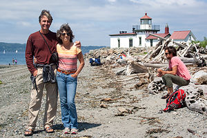 Lolo, Herb, and Andrew at West Point LighthouseThe boys went first, trying to synchronize their exit so that Herb could photo them shooting out at the same time – not a trivial matter, considering one tube was straight and the other J-shaped. Starting at the same time wouldn’t cut it. It took them only three attempts before they got a perfectly timed exit. Herb then photographed my less than graceful, sideways exit, while clutching my nose. It wasn’t pretty but it certainly was fun.
Saturday was rock climbing day. Tommy took us to one of his favorite weekend climbing spots at Exit 32 (on I90) in the town of North Bend. This is the town where the old TV series Twin Peaks was shot. We even saw the famous “Double R Diner” (now Twede’s Café), where you could get a great piece of cherry pie and a “damn fine cup of coffee.
The climbing area is actually halfway up the extremely popular hike to the summit of Little Si, so the parking lot fills up very quickly on weekends. Fortunately, we were early enough to nab the last parking spot. The climbing area is actually rather unoriginally named Exit 32 and there even is a guide book of its routes. There is also a climbing area called Exit 38 – also not very original, but it certainly does make driving directions easier.
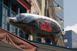 Pike Place Market Pig SculptureThe climbing here was very different from Smith Rock, both in terms of scenery and the type of rock. Rather than desert, this was a lush Pacific Northwest forest, beautiful in a different way. We set up on a wall, creatively called World Wall I, and Herb and the boys did about four climbs. There was nothing on this wall easy enough for me to do, so I was quite happy just being a spectator for the day .
After we finished climbing, we hiked the rest of the way to the summit of Little Si, along with about a hundred other people. The total hike is about 5 miles round trip, and very much worth it, as the views from its 1,576-foot summit of the Snoqualmie Valley are stunning.
Since we normally, don’t hike with a cooler – but had it along to hold our lunch while we were climbing – Herb can be forgiven for leaving it at the summit. We only discovered it was missing when we got back to the car. We even have a nice photo of Herb and I posing with it on the summit. I wonder if it is still up there.
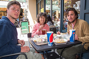 Lunch at Pike Place ChowderThat evening we just relaxed at the campground, taking turns with the kayaks out on Lake Sammamish. Andrew and I had a race between two buoys. He had me beat until he flipped his, and I cruised by for the victory.
Later, after much pestering, Tommy took Andrew out in his car to teach him how to drive stick shift. Andrew hates being the only one in the family that can’t. Tommy reported that some progress was made, and that hopefully his transmission was not any worse for wear.
Sunday was our last day together. Andrew had a flight back to San Francisco at 6:00 pm, giving us quite a bit of time to explore the city.
Our first stop, and one which had thwarted us on our visit here last year, was Discovery Park, Seattle’s largest park with 543 acres of tidal beaches, sand dunes, dramatic sea cliffs, meadows, and forests. We parked in the North Lot and set off to find the trail down to the beach and out to the lighthouse.
 Pike Place Market Mannequins with GuitarSince Tommy was our local expert and had run the trails here on several occasions, we let him lead the way. After walking to the Native American Tribal Center and enjoying the views of Puget Sound from the newly built viewing platform, he took us on a “shortcut” through a dense maple forest down along an overgrown, infrequently used trail. Despite our skepticism, we soon joined the main trail, which led us out onto a lovely beach on Puget Sound with wonderful views of the Olympic Mountains. I could have easily spent the entire day here. We strolled along the beach to the West Point Lighthouse, located on a piece of land that jutted out into the Sound. From there it was uphill on a real trail back to the car.
Our next stop was the famous Pike Place Market, and what better place to be at lunchtime? No one should come to Seattle without stopping at this iconic Seattle landmark.
I think Tommy and I were rather unoriginal in our selection of Pike Place Chowder, the same place we had eaten last year, but the chowder was just so darn good. Herb and Andrew were not as excited about our selection, because they both are allergic to shellfish and couldn’t partake in most of the menu selections.
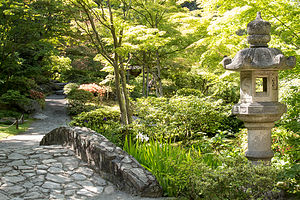 Seattle Japanese GardenAs always, there was a line out the door, but it moved pretty quickly, and Herb was able to secure us a table on the outside patio before we got our food.
Tommy and I very much enjoyed our Seafood Bisque and Dungeness Crab Roll sandwich Combo, while Herb grumbled a bit about his Alder Smoked Salmon sandwich having more bread than salmon. Andrew seemed pretty happy though with the Salmon Sandwich and a Southwest Chicken and Corn Chowder.
After lunch we strolled through the market and actually did see fish vendors tossing a salmon back and forth, as seen on TV. Then we went back through the infamous Post Alley to see the Gum Wall, where previously chewed gum of all shapes and colors covers the entire length of an alley, from street level to 6 feet above. There really is a fine line between litter and art, but I would have to go with art for this one, because it really is quite beautiful in its own way.
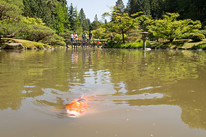 Seattle Japanese Garden KoiWe had time for one more stop before dropping Andrew off at the airport, so we drove over to the Seattle Japanese Garden, which is part of the larger Washington State Arboretum, where we briefly beached our kayaks two days back. We didn’t have much time before having to leave for the airport, so we hesitated for a moment at paying the $24 (for the four of us) admission fee for such a short visit. Feeling somewhat responsible as our tour guide, Tommy generously whipped out his credit card and paid for our entry. “I just don’t want to hear you guys grumbling,” was his official motivation. Whatever, works was fine with us.
The Garden was fairly small, just 3 ½ acres, but very, very lovely. I find Japanese gardens so peaceful and restful, which was probably what we all needed about now. The garden had a cherry orchard, babbling brooks, a teahouse, and my favorite – a beautiful pond filled with flowering lily pads and colorful koi. We noticed that the koi were coming to the surface with their mouths wide open. Herb said that this was a sign that there is not enough oxygen in the water, and they are doing that to get more air. I found it hard to believe that the koi weren’t properly managed in such a beautifully maintained park as this. I think they were just trained to look for handouts from people on the bridge over the pond.
I am so glad we stopped here. If this garden is representative of the rest of the Washington Park Arboretum, we definitely have to spend more time here on our next visit to Seattle.
Our time was up, so we drove down I5 and dropped Andrew off at the Seattle Tacoma Airport. Afterwards Tommy dropped us off at the campground and went back to his apartment to do laundry and get ready for the work week ahead. He came back though. Realizing that his commute to Microsoft was better from Vasa Park than his home, and knowing that Mom and Dad are always good for a free dinner, he returned to spend the night with us. I was happy, because I will take any time I can to spend with him.
The next morning, we said our goodbyes and he headed off to work. Now, once again after an active week with the boys, we were on our own slower paced schedule – or so we thought.
Description
Seattle
The following is in no way an attempt to give a thorough description of what to see and do in and around the city. However, the following sites are what we chose to do during our all too short visit.
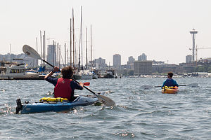 Boys Kayaking in Lake Union with Space NeedleKayaking Lake Union Lake Union is part of the Lake Washington Ship Canal System, which connects Lake Washington with Puget Sound. As far back as 1854, Thomas Mercer predicted that someday canals would join these two bodies of water in a “union of waters” -- hence the name Lake Union. Lake Union’s proximity to scenic views of Seattle makes it a popular recreational spot for power boaters, kayakers, and paddle boarders. Also of interest are the floating homes that line its shores, popularized by the movie Sleepless in Seattle. There are several parks on the shores of the lake, with Gas Works Park being the largest and most popular. There are several kayak rental shops on its shores, including Moss Bay and the NorthWest Outdoor Center.
Little Si is a very popular hiking and rock climbing destination for Seattleites. It is located about a ½ hour east of Seattle, just off Exit 32 of I90 in the town of North Bend. At 1,576 feet, it is smaller than its taller neighbor, 4167-foot Mount Si. Those planning to hike Little Si, especially on the weekends, should arrive early at the trailhead, as the parking lot often fills up early. The 5-mile hike to the summit and back leads through a lovely forest before scrambling over rocks near the top. The views of the Snoqualmie Valley from the summit are phenomenal. Little Si is also well known for its rock climbing and bouldering. The rock climbing area is located about halfway up the hike.
Discovery Park’s 534 acres makes it Seattle’s largest park. It is located in the Magnolia/Queen Anne district of Seattle. The park has a wide variety of terrain, including two miles of protected tidal beaches, active sand dunes, dramatic sea cliffs, meadows and forests, and a lighthouse. The more than 11 miles of trails includes routes along the beach and up and along the bluffs. From atop Magnolia Bluff, the views of Puget Sound and the surrounding Olympic and Cascade mountain ranges are spectacular. Maps and suggested walking/hiking routes are available at the Discovery Park Visitor Center.
Pike Place Market is one of the nation’s largest and oldest public markets. Founded in 1907, it has now become one of Seattle’s most famous and popular attractions, hosting over 10 million visitors each year. Perched atop Pike Hill overlooking Elliot Bay, the nine-acre market district consists of several levels, offering fresh produce, unique foods, handmade arts and crafts, restaurants, the first Starbucks, numerous talented street performers, and even one of the oldest head shops in the country. However, the most popular section is the upper level, pedestrian-friendly covered arcade, with its iconic huge red neon sign and fishmongers tossing salmon to the cheers of the expectant crowd.
The Seattle Japanese Garden is a 3 1/2 acre formal garden, located within the Washington Park Arboretum. It was designed and constructed under the supervision of world-renowned Japanese garden designer Juki Iida in 1960. The garden includes a cherry orchard, babbling brooks, a lake rimmed with Japanese irises and filled with flowering lily pads and colorful koi, and a teahouse. Admission is $6 for adults; $4 for ages 6-18, 65-plus, college students with ID and the disabled.
- ‹ previous
- 6 of 9
- next ›
Seattle location map in "high definition"
Javascript is required to view this map.
