Yosemite Valley, CA
Day 1 - Firefall in October!

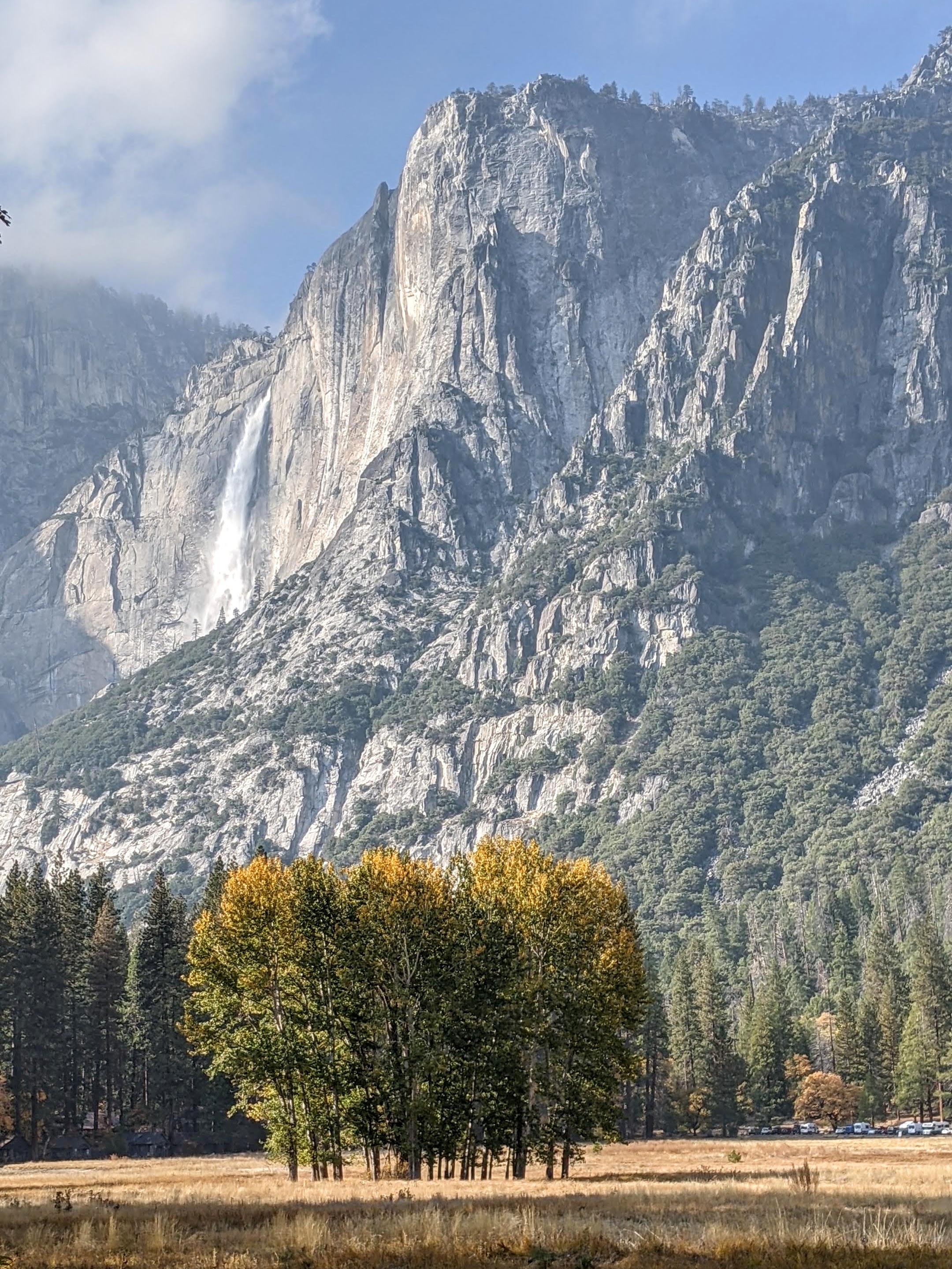
As I mentioned in the overview, we were arriving in Yosemite Valley the day after 9 to 12 inches of rain had fallen. The Merced River was raging, cascading over rocks and fallen trees, in a way we hadn’t seen it in years. This could be really good.
Also, the word on the street (or more correctly FB pages of Yosemite photographers) was that this atmospheric river might bring Horsetail Falls back to life, creating the natural firefall phenomena that normally only occurs during two weeks in February when this seasonal fall is running and the angle of light at sunset is just right.
Well, as luck would have it, Horsetail Falls was running again, and the lighting at the end of October is nearly identical to that of the February window of the Firefall.
In the old days, visitors to Yosemite did not have to wait for these perfect conditions of water and light to align. Why do that, when you can use real fire?
Starting in 1872, and continuing for almost 100 years, the owners of the Glacier Point Hotel (ironically destroyed by fire in 1969) pushed coals from a huge bonfire over the edge of Glacier Point, creating a “waterfall” of glowing red embers, which cascaded over the edge of the cliffs, like a lava flow, to the Valley 3,000 feet below.
Thousands of enthusiastic tourists gathered each summer night in the meadows of the Valley to watch this spectacle. They knew it was coming when David Curry, the founder of Curry Camp, would yell from the Valley floor, “Let the fire fall.”
This went on until 1968 when the director of the National Park Service finally questioned the wisdom of throwing burning embers down into the Valley. Also, the thousands of enthusiastic spectators were trampling through and destroying the meadows as they jockeyed for a good vantage point. The decision was made to preserve the valley and return it to its natural state.
Fortunately, Horsetail Falls stepped up and created a natural “firefall,” although not every night and only under very specific conditions, which usually occurred for a two week period in February.
Well, as they say, every cloud has a silver lining, and ours was being present in the Valley when the torrential rains which reanimated Horsetail Falls and the late October light came together to put on a spectacular show - probably made even better by the fall foliage. Oh, and you also need a third ingredient - no clouds blocking the sunset hitting the falls. Boy, were we lucky!
While the February event brings hundreds of photographers, jockeying for position, to capture the event, it was just us and one other photographer in one of the best places to view the Horsetail Falls “firefall,” which is located on the far eastern edge of the North American Wall of El Cap.

We parked in a pull-out on the right on Northside Drive where there was a view of El Cap and strained our eyes to determine if the shiny part on the cliff face was a waterfall. We thought so, but we would just have to wait and see. There was one other photographer who joined us with some serious camera equipment so that was a good sign that we were in the right place.
There were some low lying clouds, so we were a bit worried whether the sunset light would hit the falls. However, there did appear to be some blue sky beneath the clouds, so we kept our fingers crossed.
Sure enough, the sun dipped below the clouds, and at 5:32 pm, the shiny place on the rock transformed into a golden shield with an obvious thin, but ample, waterfall running down its center.
We began running around like nuts trying to find the best place to photograph it. Since I was using my phone camera, I couldn’t really get closeups, so I focused on getting the firefall with some foliage in the foreground, while Herb took the more classic shot of what looked like a lava flow.
After about 20 minutes of golden light, the color changed to a fiery red as the sun got lower in the sky - the classic shot of the falls and the reason for its name.
In another 10 minutes, the colors changed once again, this time to a lovely pastel pink and blue. By 6:10, the show was over.
What an incredible experience, and we had only arrived in the Valley 2 hours ago. We could go home now and the trip would have been a success.
Day 2 - Drive the Valley Loop, Run to Mirror Lake, Hike Four Mile Trail

The next morning we arose early (at least for us) to do what would pretty much become our morning ritual during our stay. We would drive the motorhome to the Church Bowl picnic area by the Ahwahnee Meadow for two reasons:
First, since we had pieced together our campsite reservations based on cancellations, we had to move to a different site pretty much every day, so we had to get it out of our site by 11:00.
Secondly, Church Bowl is one of the few spots in the Valley that get early morning sun, so it was a good place to charge up our solar panels. We weren’t the only ones with this idea, so we pretty much had to get there by 8:30 to nail a parking space. Most of the other occupants of the spot were twenty- or thirty-something climbers in white vans (like both of our sons) prepping for a big wall climb the following day. In fact, one out of five vehicles in the Valley were white Promaster vans.

Once the motorhome was tucked into a spot, we set off in the Subaru to drive the Valley Floor Loop in hopes of finding mist weaving among the trees decked out in the autumn yellows and oranges and/or other interesting atmospherics or reflections in the river.
We usually start off by parking before the El Cap crossover road (between the Southside and Northside Drives) and then wander along the Merced River before eventually crossing over into the lovely El Cap Meadow.
The skies were already a striking, cloudless blue, something I wouldn’t usually complain about when on vacation, but are a bit boring in a photograph. In any case, it was fun to just wander around scouting out interesting places.

After coming to the Valley dozens of times, we try to not get jaded and take the incredible scenery for granted, but rather to remind ourselves just how breathtakingly beautiful it is. Even after 35 years, that still isn’t a problem and each visit we are awed and inspired anew.
Wanting to get some exercise, we drove back to our home base at the Church Bowl Picnic area, changed into running clothes and set out on a run along the Valley Floor bike path and trail to Mirror Lake, where we were to have a second “first” in Yosemite Valley (the first “first” being the October natural firefall).

Most people don’t realize that Mirror Lake usually has no water in it, so it usually doesn’t mirror anything, but this time because of that bountiful atmospheric river of rain that had hit the Valley a few days ago, we were greeted to a reflection of North Dome in what was now truly a lake. It was absolutely lovely.
Although we did manage to run 5 miles that morning, I had a weird problem across two of my toes on my left foot - sort of painful and tingly feeling. After much googling, I ruled out a broken toe (I had 0 out of 10 of the symptoms) and determined it was most likely peripheral neuropathy caused by trauma, the trauma most likely being the pretty bad stubbing I had done in the motorhome the day before. It only seems to hurt when a push off on my toes, which is basically running (and ballet dancing, which won't be an issue , so I am switching to hiking, biking, etc., until it hopefully goes away. Herb is getting a little tired of “toe talk” so he is very much rooting for a speedy recovery as well.
.jpg)
Our final activity of the day was to be a partial hike up the Four Mile Trail to a spot where there was an excellent place to view El Cap without being totally obstructed by trees. We weren’t sure if Horsetail Falls would still have enough water to put on its Firefall showe, but we figured worse case, we would get a lovely view of sunset over El Cap.
Four Mile Trail is one of my favorite hikes from the Valley. It climbs steadily from the Valley Floor up 3,200 feet to Glacier Point over 4.8 strenuous miles (not 4 miles like the trail name would imply). We have done this hike several times in the past, but tonight was to be a shortened version - just a mile and a half or so up to where we hoped to capture the Firefall from a different perspective.
This is an extremely popular trail, and we passed dozens of people coming down, probably wondering why these old people were setting out on the trail so late in the day, as there was no way we would make it to Glacier Point before dark.’
‘

Feeling a need to explain ourselves, I told several passing hikers about the surprise October Firefall, and that we were not trying to go to the top, but just about a third of the way up to hopefully photograph it. I don't think they really cared, but I hoped that my sharing of this information got at least a few of them to try to find a place from where they could experience it themselves.
It was a little difficult finding enough of a clearing in the trees to get a full view of Horsetail Falls, but there were a few spots that worked. Then we waited, unsure whether the water and the sunset would cooperate. Oh, and the clouds too. Everything would have to be perfect.
Finally around 5:24, we got our first glimpse of the golden shield on El Cap - not quite as dramatic as last night, perhaps due to less water or our vantage point, but still a pretty good show. We knew its routine now. Soon the golden shield transformed into a narrower fiery red waterfall before ending with that incredible blue again. By 6:05 it was all over.
Another magical day in the Valley!
Day 3 - Drive the Valley Loop (morning commute), Bike Ride around the Valley, and Half Dome Reflections
.jpg)
After dropping the motorhome off at the Church Bowl picnic area for the solar panel's daily dose of sunshine, we once again set off on Northside Drive for our morning loop around the Valley Floor, hoping to be early enough to catch some mist lurking around the colorful trees.
When we got to El Cap meadow, there was certainly some interesting atmospherics going, but it didn't take us long to realize that rather than mist, this was smoke from the prescribed burn just on the other side of the Valley where the El Cap crossover road meets Southside Drive. I know these prescribed burns are important - just wish it wasn't happening while we were here.

Tommy and Erin are actually coming to the Valley on Saturday for the wedding photographer to meet them and take the photos that he wasn't able to take of them in the Valley because of the smoky conditions from actual non-prescribed fires - I think the one in Sequoia National Park. Hope this wouldn't ruin it for them. They were bringing their wedding attire so that they could be bride and groom again.
We wandered around the meadow for about a half hour, but the smoke was pretty intense. Even with our dual purpose N95 mask (great for dealing with both Covid and smoke), we were only able to last about a half hour before leaving to find clearer air.
Luckily, everything east of the El Cap Crossover road seemed to be fine.
We returned to the motorhome at Church Bowl, made lunch and then set up our chairs in the sun where we could read and/or just gaze out at the Ahwahnee Meadow and Half Dome. Having been to Yosemite Valley so many times, it's nice not feel compelled to run around frantically seeing every beautiful sight, but rather to kick back and take the time to savor them leisurely one at a time.

Since my weird toe ailment was not ready for a run, I suggested that we take a bike ride, my absolute favorite way of getting around the valley. The bike paths make for a very pleasant ride.
Although we have really nice mountain bikes, Herb was worried about theft and/or them being rained on, so we resurrected our old ones out of the attic. Of course, they all had flat tires to be dealt with. One thing that I would later learn, much to my dismay, is that in a very hot attic, over the summer the rubber on the gear shifters can melt, resulting in the unsuspecting rider’s (me) hands being covered with a sticky grease-like substance. It didn't happen to Herb's bike, just mine.
From Church Bowl we headed out towards Sentinel Drive where we left the pavement and rode along paths through the meadow before coming out by Camp 4 on Northside Drive, the famous rock climbers' camp located near the base of Lower Yosemite Falls. Some of the world’s most renowned climbers have used it as their base when climbing in Yosemite.
So important was this site to the climbing community, that when its removal was threatened in the late 1990s, a campaign was started to save it. It worked, and today it is listed on the National Register of Historic Places for "its significant association with the growth and development of rock climbing in the Yosemite Valley during the 'golden years' of pioneer mountaineering.”
.jpg)
So here we were, biking through hallowed climbing ground. Even if you don’t climb, it’s fun to just walk through this camp and watch the bouldering that goes on here. In fact, we would be doing that this weekend when Tommy and Erin arrived - spoiler alert: maybe even in wedding garb.
After peddling through Camp 4, the path led us to Northside Drive, where we crossed onto a sandy trail that paralleled the road and eventually brought us to a beautiful spot on the Merced River. This is my absolute favorite part of the Valley Loop bike ride.
From there, we took the El Cap crossover road to Southside Drive and stopped to check out the prescribed burn, which had obscured our views and filled our lungs this morning.

Although there is an unpaved Valley Loop trail that parallels Southside Drive, we had noticed that much of the Valley Loop trail was unmaintained and required frequent lifting of bikes over pretty large logs. Instead we decided to carefully bike along Southside Drive stopping at various viewpoints along the way before arriving back at the motorhome in the Church Bowl picnic area.
Fortunately, Herb had some WD40 that worked wonders on removing the sticky, rubbery grease from my hands. To prevent any future messes, he taped up the handles with climbing tape.
That evening we found a secluded beach on the Merced near Sentinel Bridge where we could watch Half Dome do its alpenglow thing without being surrounded by dozens of tripods.
Day 4 - Vernal Falls Hike and Cocktail Hour in Cook’s Meadow

While the Valley Floor loop trails lead past innumerable breathtaking Yosemite icons without the need to strenuously gain elevation, there are three not-to-be-missed trails that require a bit more work, aka elevation gain.
The hike to the top of Yosemite Falls gains 2,700 over 3.6 miles (9.6-mile RT hike). I think this is probably the most strenuous hike out of the Valley, but well worth the reward at the end.
The hike from the Valley to Glacier Point via the Four Mile Trail gains 3,200 feet over 4.8 miles (9.6-mile RT hike). Another terrific hike that feels a bit less strenuous than the Yosemite Falls hike even though it has a greater elevation gain, because it is done over a longer distance.
.jpg)
The hike to the top of Vernal Falls is 2.1 miles with a 1,551-foot elevation gain (4.2-mile RT). If you continue on to Nevada Falls it is a total of 5.8 miles RT with a 2,000-foot elevation gain. This is by far the most popular hike out of the Valley because it has a lot of bang for the buck and is the least strenuous.
Mainly because of my injured toe, we decided to do the Vernal Falls hike, going up the Mist Trail and returning via the John Muir trail in order to make it a loop.
Because of Covid, no shuttles were running in the park, so we rode our bikes to Happy Isles where the Mist Trail begins.
This is one of the most popular hikes in the Valley, so we had no expectations of finding solitude on the trail, but even we were surprised by the steady stream of people of all ages, shapes, sizes, and foot gear.
The first mile of the trail is partially paved and almost entirely uphill. After 0.8 miles and about a 500-foot elevation gain, we came to the Vernal Falls footbridge where there is a good view looking up at the falls.
After crossing the bridge, in about 0.2 miles we came to a junction in the trail, with the Mist Trail continuing to the left and the John Muir Trail to the right. We planned to do a loop, so we followed the Mist Trail up a steep granite staircase with over 600 steps to the top of Vernal Falls. There’s nothing like strenuous physical activity to thin a crowd, so already we were finding ourselves with a bit more peace and solitude.
The trail is named the Mist Trail, because the mist from the falls normally sprays hikers and the trail itself, often making it quite slippery. In times of drought or in late summer, there is often no mist on the Mist Trail, but fortunately for us, the torrential rains a few days ago, which brought us our October surprise firefall, were also delivering us mist.
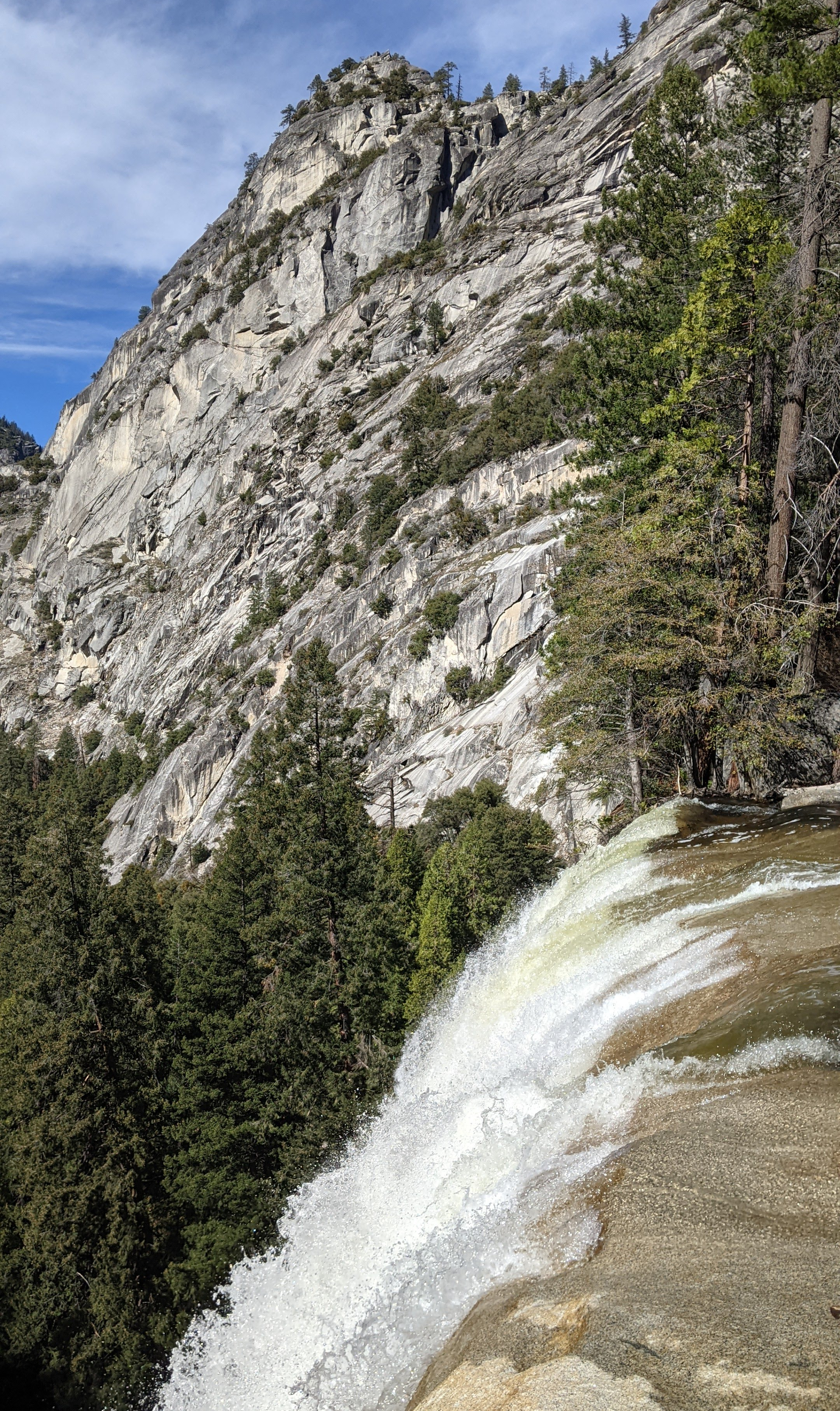
From the top of Vernal Falls, we took our turn to get to the metal railings where we watched the river flow over the edge and down the length of the 317-foot waterfall.
Just beyond the top of the falls, we stopped to eat lunch by the Emerald Pool, a small shallow lake named for its deep green color. At the far end of the lake is the Silver Apron, a smooth granite mass, tilted in such a way to invite its use as a water slide in the summer when the river flows over this. There are numerous signs warning people not to do this, or enter the Emerald Pool for any reason, as you risk being swept over the Vernal Falls by currents that are much stronger than they appear. People have been killed here before.
Rather than go back the way we came, which would require us going down the steep, slippery 600 steps through the mist, we decided to continue on another 0.2 miles where we came to the junction with the John Muir Trail.
.jpg)
The hike down the John Muir Trail was a little less scenic than the Mist Trail, but it still had a nice view of Nevada Falls and Liberty Cap in the background.
Once back at Happy Isles, we reconnected with our bikes and rode the 2 and ½ miles back to our motorhome at Church Bowl, stopping to admire Half Dome along the way.
As we did every day, we moved the motorhome back to our campsite (the 4th one in 4 days since I pieced this trip together on cancellations) before it got dark.
We filled the cooler with wine and cheese and headed over to Sentinel Bridge where we parked, took our chairs and cooler, and sat at the edge of Cook’s Meadow admiring Yosemite Falls cascading above the lovely fall foliage.
Another day in Paradise comes to a close.
Day 5 and 6- Weekend with Tommy and Erin - Wedding Photography, Bouldering in Camp 4, and Cocktail Hour in Cook’s Meadow

Tommy and Erin arrived late last night -- too late to actually see them, but when I awoke in the middle of the night, I did peek to see that they were tucked in safely and soundly. That was after I had left some pillows in their bear box because they called earlier to tell me that forgot theirs.
They are very frequent weekend visitors to Yosemite, as they both love to rock climb, they have a built-out Promaster camper van, and San Francisco is just 4 hours away, making it a viable weekend trip.
However, this particular visit was a bit unique, because besides packing their normal climbing gear, they had also brought along Erin’s wedding dress and Tommy’s suit.
Just three weeks ago, they had gotten married at the Evergreen Lodge, a beautiful rustic lodge and cabins near the northwest entrance to the park, near Hetch Hetchy. Their wedding was absolutely sensational and so much fun. Destination weddings are so much more relaxed and fun because you get to spend several days with your guests.
The only glitch in an otherwise perfect event was that the smoke from the Sequoia fire decided to attend the wedding as well. Although the Air Quality Index (AQI) was around 170, which isn’t great, everybody was having too much fun to even notice. I think the dancing and the open bar probably helped a bit.

Their photographer had planned to take them down to the Valley the day after the wedding to take photos of them in a place that was very special to them. One of their earliest dates had been a 3-day ascent up the Nose route of El Cap, basically testing the fabric of their young relationship. Their relationship not only survived, but it thrived and now four years later, they tied the knot - not a literal knot like in climbing, but the metaphorical one representing their lifelong commitment to each other.
Well, since that originally intended photo session the day after their wedding didn’t work out because the smoke was so thick in the Valley that you couldn’t even see El Cap, their photographer was nice enough to agree to come back to Yosemite on another weekend of their choosing. He lived relatively close by in Mariposa.

So, this was the big weekend. Erin had had her dress dry cleaned and repaired from too much dancing and partying, so she was ready to be a bride again. At least she was getting two uses out of it.
None of the photos I am posting on this page were taken by the Patrick, their professional wedding photographer. Those still have to be sorted through and edited before Tommy and Erin receive them. Instead, the photos on this page were were taken by either me or Herb stealthily standing behind or to the side of Patrick. Tommy made me swear beforehand that I wouldn't get in his way. Who me?
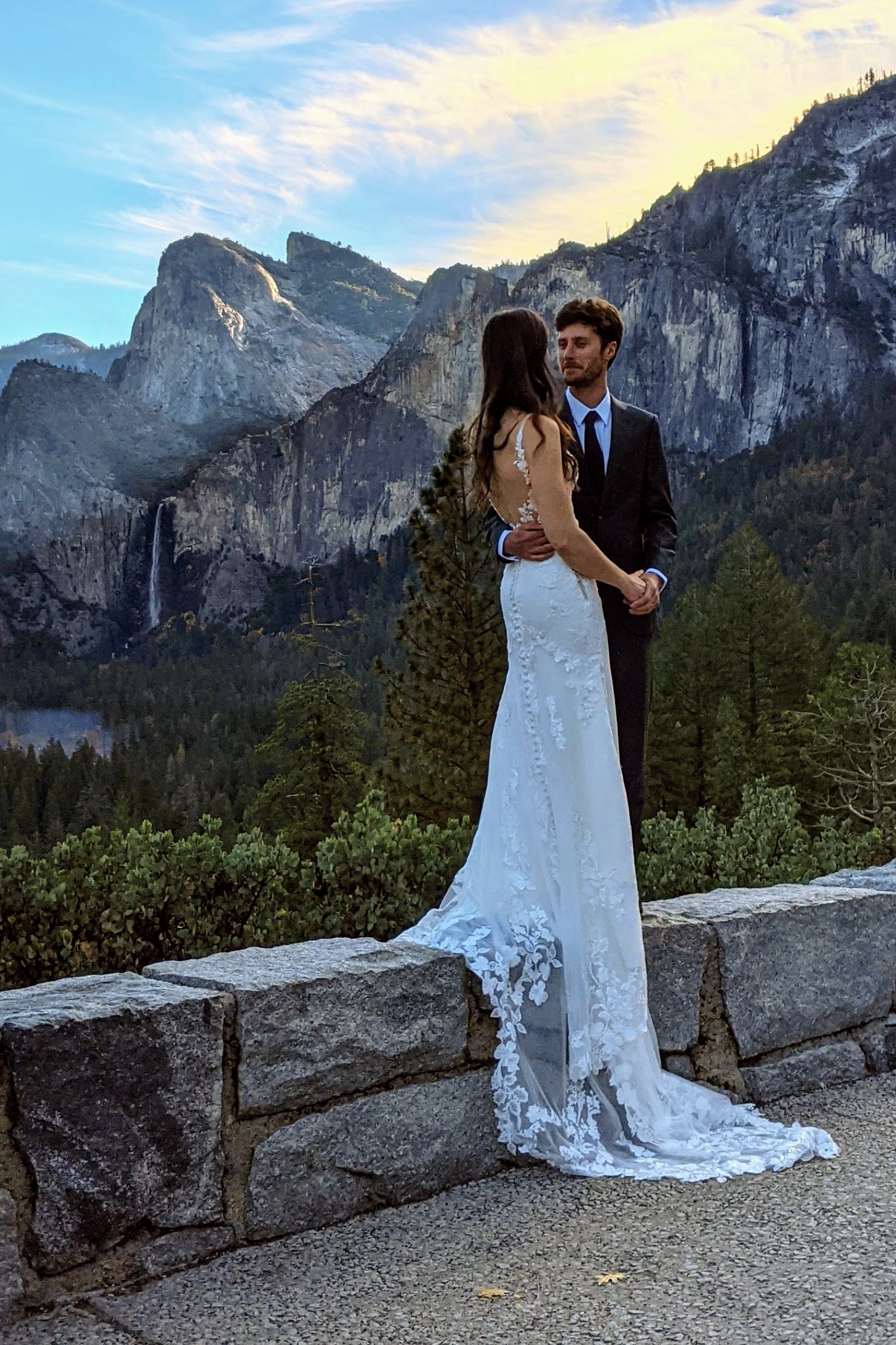
We met Patrick at the Wawona Tunnel viewpoint, where there is an iconic and breathtaking view of El Capitan, Half Dome, and Yosemite Valley in between.
This is always an extremely crowded place, so Erin was a bit embarrassed stepping out of their camper van wearing a wedding dress, but I think people are pretty used to seeing brides in the Valley as it has become a very popular place to get married. Patrick said a big part of his business is photographing Yosemite elopements. It is such a beautiful and spiritual place.

Being a local, Patrick knew lots of beautiful, yet still secluded places to go. He also had a really good eye to capture things spontaneously based on conditions. At one point, when driving on the El Cap crossover road, near the prescribed burn, he just pulled over to the side of the road and asked Tommy and Erin to walk down the road a bit. Fortunately, no cars were coming. What he had seen from his rear view mirror was the way the sun coming through the smoke was creating what photographers call “god rays.” It made for a very magical, fairytale-like setting.
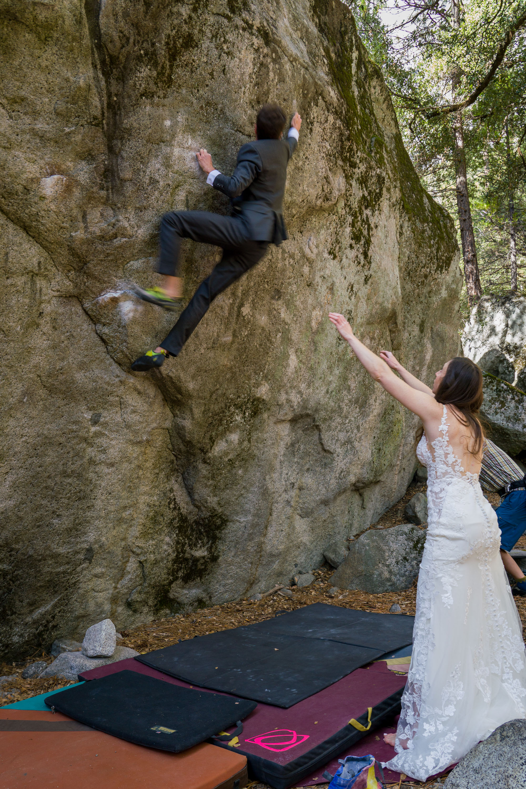
A few more stops and then Tommy and Erin wanted to get down to the business of the day - bouldering at Camp 4. Although Patrick had already far exceeded the hour he had promised him, I think he was very professionally motivated to get some shots of Erin climbing in a wedding dress. So, the good news was, he came with us. The bad news was, Tommy and Erin couldn’t take their fancy clothes off just yet. The pictures, however, were absolutely worth it.
After saying our thank yous and goodbyes to Patrick, Tommy and Erin immediately took off their wedding attire and put on something a bit more appropriate for climbing. Starved from all that posing, we went over to Yosemite Lodge for a quick lunch at the Base Camp Eatery, a cafeteria-style restaurant with burgers and pizza.
Relaxed and more comfortable, we stopped to pick up the crash pads in the van and then wandered through Camp 4 looking for potential boulders to climb (Tommy and Erin that is, not me and Herb).
As usual, there was a group of climbers gathered around “Midnight Lightning,” the most famous bouldering problem in the world and an iconic part of the history of Yosemite rock climbing. We’ve never been there when there wasn’t at least a dozen climbers and an equal number of crash pads at its base to soften the falls from failed attempts - and with bouldering, there is a very high percentage of failed attempts, as it often takes weeks or even months for a climber to work out the moves on a difficult boulder problem and successfully “send it.”
Midnight Lightning is easily identified by a chalk lightning bolt, which was originally drawn on it in 1978 by John Bachar, the second climber to complete it (Ron Kauk was first). Since that time, the bolt has been erased by those that consider it graffiti and redrawn by those that think it an essential part of the history and spirit of Yosemite climbing. I liked it - it reminded me of a petroglyph.
Having been on it several times in the past, Tommy decided to take a go at it again. They added their crash pads to the pile and Tommy took his turn in between the other climbers. Taking turns was very civilized, Those waiting spotted the active climber, and the next climber stepped up after the previous climber had either fallen or sent the climb. On Tommy's third attempt, looking very strong and smooth, he “sent’ it, to the cheers of the very supportive group of climbers below. Nice way to cap the day!
Somewhat fortuitously, one of the other climbers that was spotting him had left his camera video running and captured Tommy's successful attempt. Even more fortuitously, they had met him before when climbing in Tahoe, so he said he would send it to them. The climbing world is a surprising small one and every where they go they usually run into people they have climbed with before.
After they had gotten their fill of bouldering for the day, we brought them to our new favorite new cocktail hour spot in Cook’s Meadow near Sentinel Bridge, where we set up our chairs and sat for a while sipping wine and munching on cheese and crackers, just taking in the scenery.

Although Tommy and Erin were pretty done posing for the day, I did get them to pose one more time on a giant log with the fall foliage and Yosemite Falls in the background. The combination of fall foliage and enough water to make Yosemite Falls flow is not something you always get this time of year, as the water often dries up by the end of summer. This trip was just overflowing with fortuitous events.
What a wonderful day!
We spent the next morning following Tommy and Erin around Camp 4, watching them attempt various different boulder problems. Although Herb and I like rock climbing, we prefer the rope kind rather than bouldering as our older bones don’t like the impact of even short falls onto crash pads. So, we were very happy just spectating and hanging out with them.
After they left, I decided to test the sore toe out on a run, but it didn’t go too well. Although I did manage to go 3 and ½ miles, I was in a bit of pain the entire time. Even the incredible scenery couldn’t distract me enough.

I headed off from Church Bowl along the Valley Floor loop to Yosemite Village, where I made a quick stop to go into the Ansel Adams Gallery, which I love. Obviously, this wasn’t going to be a very serious run if I was stopping to shop. Too bad I didn't have my wallet.
From there I continued on through Yosemite Village, past the Visitor Center, which is still closed because of Covid, and then through the Yosemite Cemetery, where many of Yosemite’s early residents, including Native Americans and well-known figures in the history of the park, are buried. This is a spot definitely worth coming back to explore more when I am not theoretically running.
Next stop, the lovely Lower Yosemite Falls, which is pretty much always crowded as it is so highly scenic and so easily accessible. I waited my turn to get in the best position for a photo - sort of the way the climbers on Midnight Lightning yesterday knew when it was their turn to step up. The tough part was finding a spot where both the Upper Falls and the Lower Falls were in the photo. It really is an incredibly beautiful spot.
The foot wasn’t exactly getting any better, so I reluctantly decided to head back, even though I had only gone 3 miles, rather than my usual 5 miles. I drive Herb crazy when I obsessive compulsively continue running around parking lots if we get back to our car when my watch shows we are only at 4.9 miles. Now I was concerned. This foot thing must be more serious than I thought.
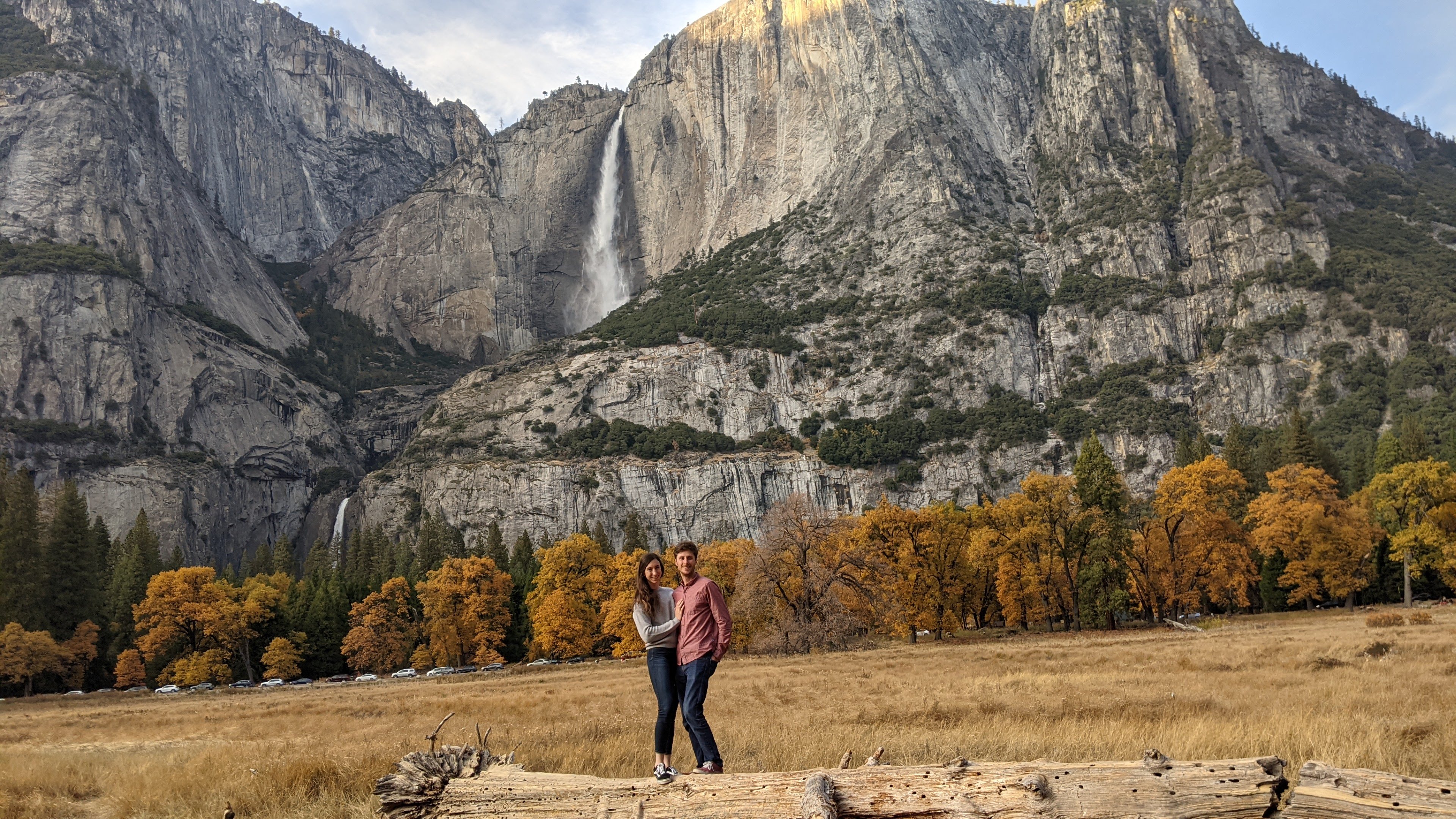
However, rather than go directly back to the motorhome, I made one quick side trip to the other side of the Ahwahnee Meadow from Church Bowl (and our motorhome), to take a photo of Yosemite Falls with my favorite group of trees in the foreground. They were just beginning to show their fall colors - yellow on the leaves on top. When we got here a few days ago, the trees were completely green. Oh, and of course I had to take a photo of good old Half Dome, which we had been neglecting this trip, spending much more time with El Cap.
The extra diversion brought my distance to 3 and 1/2 miles.
Rather than spend the whole evening back in the motorhome in the campground, we drove over to the Ahwahnee Lounge to hang out with our books and a bottle of wine. I love historic national park lodges, and in my opinion, the Ahwahnee, with its rustic wooden-beamed ceiling, giant fireplace, and plenty of cozy nooks to hide away in, is one of its finest. I have so many fond memories of spending time here in the evenings with the boys reading, playing cards, or just chatting. It’s my happy place.
Day 7 - Lazy rainy morning, morning commute around Valley, and dinner at the Mountain Room Lounge

We awoke to the pitter patter of rain on our roof. The first day of rain in a string of six gorgeous Indian Summer days. The change was actually a welcome one in that it opened up the opportunity so see the Valley under different conditions - same location with different conditions equals a different photo.
We had been getting out early every morning chasing morning light photos around the Valley, so we decided to take it easy this morning and sleep in, or at least read in. After all, we are retirees.
So, we did one of my favorite things - opened the blinds of our expansive windows in the back of the motorhome, grabbed a good book, and alternated between reading and watching the activity in the campground around us. I always appreciate the motorhome so much more when watching tent campers deal with the rain. It’s just so darn cozy in here.
Eventually, we dragged ourselves out of the motorhome, leaving it for once in its campsite, as we actually now had one for more than one night, and headed out in the Subaru to do our circle around the Valley.
Everything did look different, especially the lack of smoke from the prescribed burn over by El Cap. And we could breath again. Apparently, the rain had brought the smoke particles down along with it, and now rather than flames, the burn was just a bit of steam.
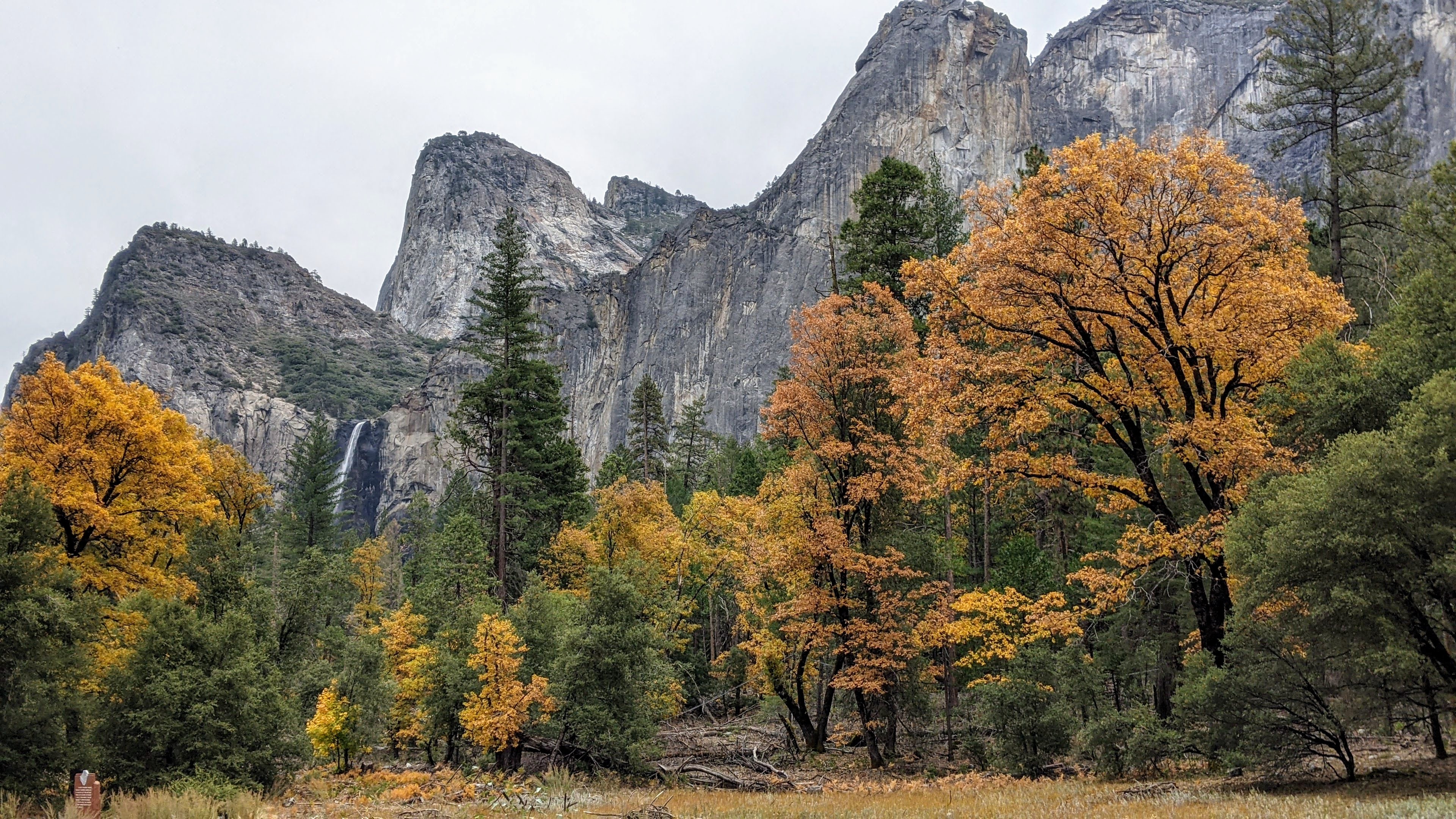
We wandered around taking photos of some old favorites and also some new ones. Bridalveil Falls was looking pretty good. It is generally a year-round fall, but it was particularly feisty with all the recent rain.
After completing our circuit of the Valley, we returned to the motorhome, which we had actually left behind in the campground today. Finally, we were staying in the same campsite for more than one night.
We decided to have date night and go out for dinner. Because of Covid, the options were fairly limited. The Ahwahnee dining room was only taking reservations for hotel guests and the Mountain Room at Yosemite Lodge was closed.
However, the Mountain Room Lounge was open and serving pizza and craft beers. Sounded perfect. The setting was actually quite nice - large windows and a Swedish-style fireplace to add to the ambiance. The vegetarian pizza we had was quite good and they had a nice selection of craft beers. It was a great alternative to cooking in the motorhome.
Despite being a negative, the rain today was actually a nice change.
.
Day 8 - Grand Finale - Morning Commute, 17-mile bike ride around Valley, Dinner at the Ahwahnee Bar
.jpg)
I hate being repetitive, but we got up in the morning, parked the motorhome on Southside Drive, near the Yosemite Valley Chapel where there was that wonderful view of Yosemite Falls with foliage in the foreground, and then did one last drive around the Valley stopping wherever the scenery looked look - so, in other words, we stopped a lot.
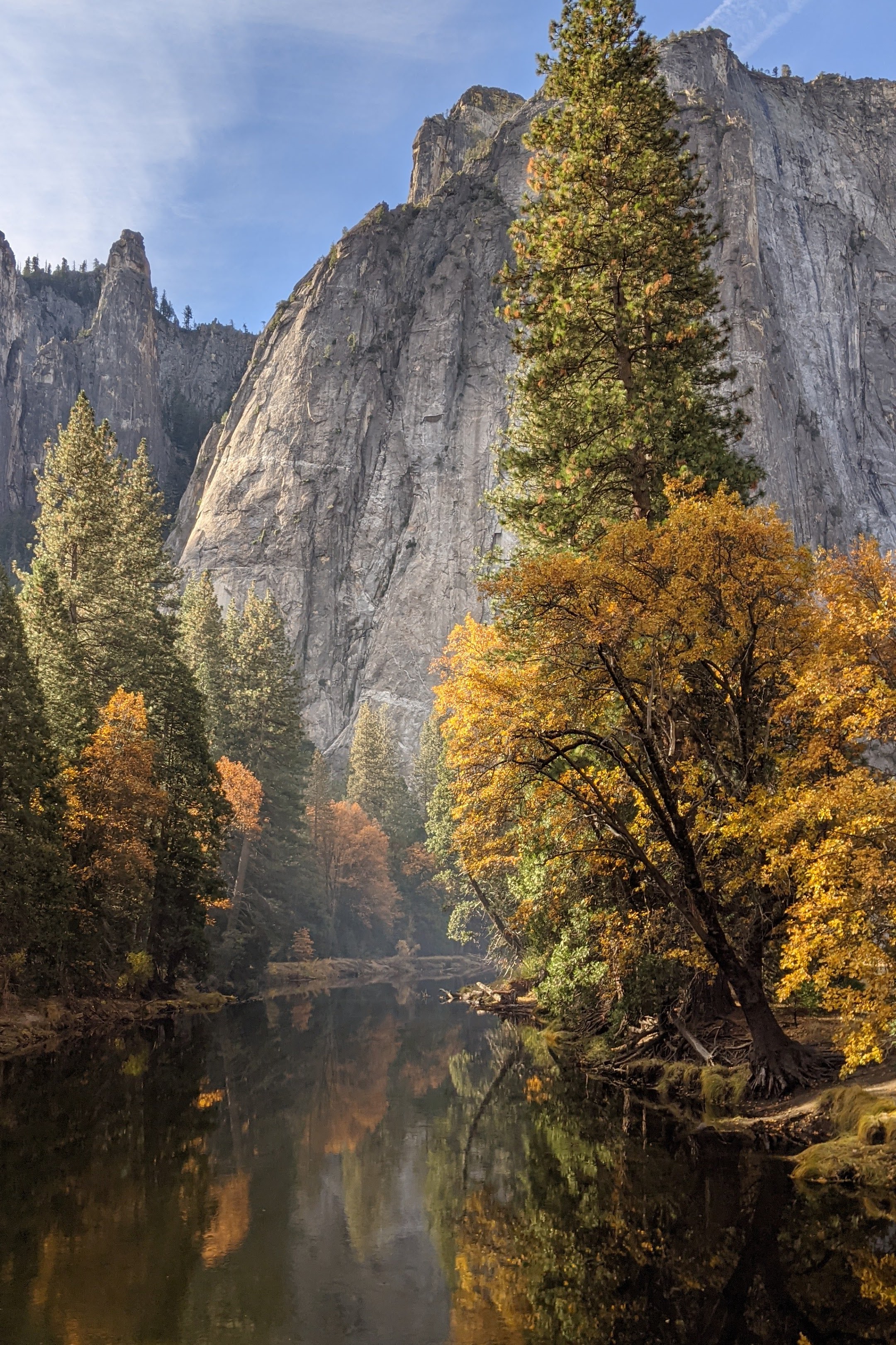
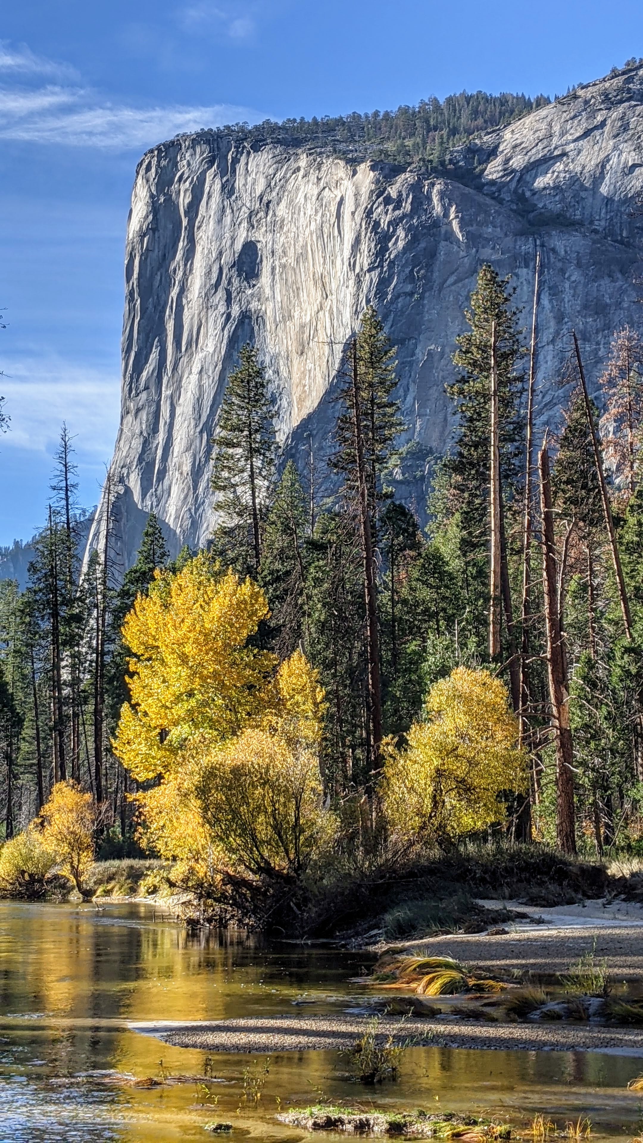
We did return to what I consider to be the most photogenic spot in the entire Valley, because the day before a photographer with a tripod had situated himself in the absolutely best vantage point and had no intention of moving for some time.
To get to it, you have to park along Southside Drive about ½ mile west of the turnoff for Wawona Road. From there, you just walk a short distance to the river looking for an opening with red foliage on the right, and a lovely bend in the Merced River flowing directly towards El Cap in the background.
.jpg)
After lunch back in the motorhome, we decided we needed some exercise so hopped on our bikes for another loop around the Valley. As I have mentioned before, bikes are my absolute favorite mode of transportation. It’s so nice to just cruise along with the scenery rushing by -- actually the scenery was standing still and we were doing the rushing.
We set off east on Southside Drive past the cute little Chapel, made a left on a path that went along a bridge over the Merced and brought us to the Northside Drive near the path to Little Yosemite Falls.
Skipping that for now, we crossed Northside Drive to get on the bike path that brought us through Camp 4 before crossing the road again to a dirt path that eventually brought us to one of our beaches along the river.
Continuing on, we got back to the Northside Drive, right near El Cap, but rather than take the road we continued straight on a dirt trail between El Cap and the road. It was also the way that climbers setting out to climb it reached its base.

The trail was really nice, but obviously not maintained. Every 1/2 mile or so we would come upon a huge tree which had fallen across the path, requiring us to do some he avy lifting of our bikes over it. After the fourth time we had to do this, we decided to get back out onto Northside Drive for a smoother ride.
We stopped at a pullout, where there were at least half a dozen people with tripods set up, to see what they were looking at. It turned out to be a very good view of Bridalveil Falls that we hadn’t seen before.

Next stop was the popular Valley View pullout where there is an iconic view of El Capitan on the left and Cathedral Rocks on the right, framing a magnificent valley view - hence, the name.
On the way back along Southside Drive, we made a few more stops: the official Bridalveil Falls Viewpoint, and a spot along the river opposite the Four Mile Trailhead.
As we passed the motorhome, Herb said he had one more stop he wanted to make, to a place he remembered from years ago when we stayed at Housekeeping Camp about 9 years ago. Hey, I was game. I was trying to get to 20 miles and this would help.
First let me explain a little bit about Housekeeping Camp, as it is a rather unusual place to stay, straddling the line between camping and hotel accomodations. The units (as they are romantically referred to) are pretty rustic. They consist of three concrete walls with the fourth wall being a canvas curtain that you can tie closed. The roof is canvas and extends out over a small patio area with a picnic table and a bear-proof food-storage box. Inside the “unit” is a bunk bed, double bed, small table, and a mirror. Linens for the bed are an extra $2.50 per night. Not exactly the Ahwahnee, but comfortable enough.
When we stayed here in 2012, I was a little jealous when I saw how many of the other units were so cozily decorated, with cute little outside lights, lamps from home, nice quilts, etc. – so warm and homey. Ours had more of a prison cell feel. We hadn’t known what to expect.
The location is absolutely phenomenal – just a stone’s throw away from a nice sandy beach along the Merced River with terrific views of Yosemite Falls. To get to that nice sandy beach you have to walk across a wood and stone bridge with one of the best views of the Falls in Yosemite Valley.

It was this bridge Herb wanted to find. So, he pedaled into Housekeeping Camp, which is really big (there are 266 units) and proceeded to get lost. Giving up on finding the bridge, we went back out to Southside Drive, turned left, and after the last unit, found a path on the left leading to the river. We took it and sure enough, we came to the bridge.
Herb was right. It did have a tremendous view of the River and the Falls.
We continued on past the bridge, going through what I think used to be either Lower or Upper Pines campground, which were destroyed in the 1997 Merced River Flood. These two campgrounds no longer exist, leaving only three others (Upper, North, and Lower Pines) to accommodate the thousands of people that desperately try to get a reservation.
Surprisingly, we popped out back on Northside Drive in the exact spot I wanted to be - by the Ahwahnee Meadow where in one direction you can see Half Dome and in the other, Yosemite Falls with a lovely stand of trees in the foreground. I acted like I knew this is where we were headed all the time.

After stopping for a few more photos, we biked back to our motorhome by the Yosemite Chapel. It had been a great ride, even if it fell short by a few miles of my 20-mile goal.
That evening, we had another date night, this time at the Ahwahnee Hotel Bar, where I had New England Clam Chowder and an Artichoke Salad and Herb had a Pulled-Pork Sandwich.
Not a bad way to end what had been a really fun trip - filled with many old favorites and some incredible firsts.
I’m sure we will be back!